 with our Megalithic Portal iPhone app")

<< Our Photo Pages >> Engraved Face of Closeau - Rock Art in France in Ile-de-France:Seine-et-Marne 77
Submitted by neolithique02 on Thursday, 19 June 2014 Page Views: 2650
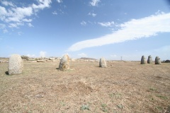
Rock ArtSite Name: Engraved Face of CloseauCountry: France Département: Ile-de-France:Seine-et-Marne 77 Type: Rock Art
Nearest Town: Malesherbes Nearest Village: Nanteau-Sur-Essonne
Latitude: 48.315090N Longitude: 2.408530E
Condition:
| 5 | Perfect |
| 4 | Almost Perfect |
| 3 | Reasonable but with some damage |
| 2 | Ruined but still recognisable as an ancient site |
| 1 | Pretty much destroyed, possibly visible as crop marks |
| 0 | No data. |
| -1 | Completely destroyed |
| 5 | Superb |
| 4 | Good |
| 3 | Ordinary |
| 2 | Not Good |
| 1 | Awful |
| 0 | No data. |
| 5 | Can be driven to, probably with disabled access |
| 4 | Short walk on a footpath |
| 3 | Requiring a bit more of a walk |
| 2 | A long walk |
| 1 | In the middle of nowhere, a nightmare to find |
| 0 | No data. |
| 5 | co-ordinates taken by GPS or official recorded co-ordinates |
| 4 | co-ordinates scaled from a detailed map |
| 3 | co-ordinates scaled from a bad map |
| 2 | co-ordinates of the nearest village |
| 1 | co-ordinates of the nearest town |
| 0 | no data |
Internal Links:
External Links:
I have visited· I would like to visit
neolithique02 has visited here
")
Based on a comparison of statue-menhirs from Guernsey to Switzerland, Closeau stela might be one of the oldest engraved Neolithic monuments known in France.
You may be viewing yesterday's version of this page. To see the most up to date information please register for a free account.
")
")
Do not use the above information on other web sites or publications without permission of the contributor.
Nearby Images from Flickr


The above images may not be of the site on this page, but were taken nearby. They are loaded from Flickr so please click on them for image credits.
Click here to see more info for this site
Nearby sites
Click here to view sites on an interactive map of the areaKey: Red: member's photo, Blue: 3rd party photo, Yellow: other image, Green: no photo - please go there and take one, Grey: site destroyed
Download sites to:
KML (Google Earth)
GPX (GPS waypoints)
CSV (Garmin/Navman)
CSV (Excel)
To unlock full downloads you need to sign up as a Contributory Member. Otherwise downloads are limited to 50 sites.
Turn off the page maps and other distractions
Nearby sites listing. In the following links * = Image available
854m E 83° Nanteau-sur-Essonne Passage Grave
1.2km SSE 168° Hypogée de Rouville Passage Grave
1.3km SE 133° Grotte de Villetard Rock Art
2.2km SE 145° Grotte de Malesherbes Rock Art
3.0km WNW 287° Grotte de Prinvaux* Cave or Rock Shelter
3.2km SE 134° Vallée aux Noirs engravings* Rock Art
3.6km SSE 158° Hypogée Le Guichet Passage Grave
4.0km SSW 197° Pierre de la Chaise Standing Stone (Menhir)
4.3km N 2° Les Sept Coups d'Epée* Polissoir
4.7km NE 51° Menhir de la Croix Saint Jacques* Standing Stone (Menhir)
4.9km NNW 345° Hypogée du Champtier des Bureaux Passage Grave
5.2km NNW 343° Buno-Bonnevaux polissoir Polissoir
5.3km N 352° Hypogée de la Fontaine Saint-Léger Passage Grave
5.4km S 178° Dolmen de Mailleton Burial Chamber or Dolmen
5.7km SE 139° Roche-aux-Loups Dolmen Burial Chamber or Dolmen
5.7km NNW 331° Menhir de la Pierre Droite (Prunay)* Standing Stone (Menhir)
5.9km NE 34° Menhir dit la Pierre aux Prêtres* Standing Stone (Menhir)
7.0km E 84° L'abri Leuillet Rock Art
7.2km N 2° Menhir dit la Pierre Droite (Paly)* Standing Stone (Menhir)
8.3km ESE 119° Pierre de l'Armoire* Burial Chamber or Dolmen
8.5km NNW 344° Grotte de Tramerolles Cave or Rock Shelter
9.3km NE 52° Noisy-sur-Ecole Sepulture Passage Grave
10.1km NE 46° Abri de Ségognole Cave or Rock Shelter
10.2km ENE 57° Grotte de Noisy-sur-Ecole II Rock Art
10.4km NE 46° Grottes de Noisy-sur-Ecole I Rock Art
View more nearby sites and additional images


 We would like to know more about this location. Please feel free to add a brief description and any relevant information in your own language.
 Wir möchten mehr über diese Stätte erfahren. Bitte zögern Sie nicht, eine kurze Beschreibung und relevante Informationen in Deutsch hinzuzufügen.
 Nous aimerions en savoir encore un peu sur les lieux. S'il vous plaît n'hesitez pas à ajouter une courte description et tous les renseignements pertinents dans votre propre langue.
 Quisieramos informarnos un poco más de las lugares. No dude en añadir una breve descripción y otros datos relevantes en su propio idioma.