

<< Our Photo Pages >> Little Sark Dolmen - Burial Chamber or Dolmen in Channel Islands and Isle of Man in Guernsey
Submitted by ShamrockStone on Saturday, 05 April 2014 Page Views: 6703
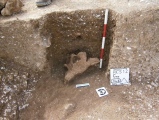
Neolithic and Bronze AgeSite Name: Little Sark DolmenCountry: Channel Islands and Isle of Man Island: Guernsey Type: Burial Chamber or Dolmen
Nearest Village: Sark
Latitude: 49.410920N Longitude: 2.37058W
Condition:
| 5 | Perfect |
| 4 | Almost Perfect |
| 3 | Reasonable but with some damage |
| 2 | Ruined but still recognisable as an ancient site |
| 1 | Pretty much destroyed, possibly visible as crop marks |
| 0 | No data. |
| -1 | Completely destroyed |
| 5 | Superb |
| 4 | Good |
| 3 | Ordinary |
| 2 | Not Good |
| 1 | Awful |
| 0 | No data. |
| 5 | Can be driven to, probably with disabled access |
| 4 | Short walk on a footpath |
| 3 | Requiring a bit more of a walk |
| 2 | A long walk |
| 1 | In the middle of nowhere, a nightmare to find |
| 0 | No data. |
| 5 | co-ordinates taken by GPS or official recorded co-ordinates |
| 4 | co-ordinates scaled from a detailed map |
| 3 | co-ordinates scaled from a bad map |
| 2 | co-ordinates of the nearest village |
| 1 | co-ordinates of the nearest town |
| 0 | no data |
Internal Links:
External Links:
I have visited· I would like to visit
ShamrockStone has visited here
")
Turn left, following the signs to Venus Pool. At the end of the road take the footpath on the right. Enter the meadow through the gate. Cross the meadow and use the steps to the next footpath leading to the dolmen.
You may be viewing yesterday's version of this page. To see the most up to date information please register for a free account.
Do not use the above information on other web sites or publications without permission of the contributor.
Nearby Images from Flickr


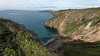


The above images may not be of the site on this page, but were taken nearby. They are loaded from Flickr so please click on them for image credits.
Click here to see more info for this site
Nearby sites
Click here to view sites on an interactive map of the areaKey: Red: member's photo, Blue: 3rd party photo, Yellow: other image, Green: no photo - please go there and take one, Grey: site destroyed
Download sites to:
KML (Google Earth)
GPX (GPS waypoints)
CSV (Garmin/Navman)
CSV (Excel)
To unlock full downloads you need to sign up as a Contributory Member. Otherwise downloads are limited to 50 sites.
Turn off the page maps and other distractions
Nearby sites listing. In the following links * = Image available
273m NNW 328° Little Sark Cist* Cist
717m NNW 344° La Gaudinerie Field Menhir* Standing Stone (Menhir)
795m NNW 338° Fontaine Bay Cist* Cist
2.5km NNE 25° Sark Ancient Settlement Ancient Village or Settlement
4.2km N 4° L'Eperquerie Cist* Cist
8.6km NW 310° Jethou Stone Standing Stone (Menhir)
9.4km NW 322° Grand Monceau* Burial Chamber or Dolmen
9.5km NW 321° Robert's Cross* Burial Chamber or Dolmen
9.6km NW 321° Petit Monceau* Burial Chamber or Dolmen
9.6km NW 322° The Common (Herm)* Burial Chamber or Dolmen
12.2km WNW 293° Guernsey Maritime Museum Museum
13.1km WNW 282° Sausmarez Manor Menhir* Standing Stone (Menhir)
13.4km NW 304° Delancey* Burial Chamber or Dolmen (WV346810)
13.5km WNW 293° La Pierre de L'Hyvreuse Standing Stone (Menhir)
13.6km WNW 294° La Petite L'Hyvreuse Passage Grave
13.6km WNW 303° La Pointue Rocque* Standing Stone (Menhir)
13.6km WNW 283° La Gran'mere du Chimquiere* Standing Stone (Menhir)
13.7km NW 314° Le Dehus* Burial Chamber or Dolmen
13.9km WNW 299° Le Chateau Du Marais* Artificial Mound
13.9km NW 310° La Roque qui Sonne* Passage Grave
14.0km WNW 291° La Petite Longue Rocque des Granges* Standing Stone (Menhir) (WV326785)
14.1km WNW 292° Courtil D'Ydol de St Jacques Standing Stone (Menhir)
14.1km WNW 303° Route St Clair* Standing Stone (Menhir) (WV339812)
14.4km WNW 292° La Grande Pouquelaye Passage Grave
15.3km NW 307° St Michel Du Valle* Not Known (by us)
View more nearby sites and additional images


 We would like to know more about this location. Please feel free to add a brief description and any relevant information in your own language.
 Wir möchten mehr über diese Stätte erfahren. Bitte zögern Sie nicht, eine kurze Beschreibung und relevante Informationen in Deutsch hinzuzufügen.
 Nous aimerions en savoir encore un peu sur les lieux. S'il vous plaît n'hesitez pas à ajouter une courte description et tous les renseignements pertinents dans votre propre langue.
 Quisieramos informarnos un poco más de las lugares. No dude en añadir una breve descripción y otros datos relevantes en su propio idioma.