
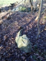

<< Our Photo Pages >> Tinghøjene - Round Barrow(s) in Denmark in Syddanmark
Submitted by PeterR87 on Tuesday, 12 November 2013 Page Views: 1676
Neolithic and Bronze AgeSite Name: TinghøjeneCountry: Denmark County: Syddanmark Type: Round Barrow(s)
Nearest Town: Rødding Nearest Village: Sønder Hygum
Latitude: 55.372356N Longitude: 8.981908E
Condition:
| 5 | Perfect |
| 4 | Almost Perfect |
| 3 | Reasonable but with some damage |
| 2 | Ruined but still recognisable as an ancient site |
| 1 | Pretty much destroyed, possibly visible as crop marks |
| 0 | No data. |
| -1 | Completely destroyed |
| 5 | Superb |
| 4 | Good |
| 3 | Ordinary |
| 2 | Not Good |
| 1 | Awful |
| 0 | No data. |
| 5 | Can be driven to, probably with disabled access |
| 4 | Short walk on a footpath |
| 3 | Requiring a bit more of a walk |
| 2 | A long walk |
| 1 | In the middle of nowhere, a nightmare to find |
| 0 | No data. |
| 5 | co-ordinates taken by GPS or official recorded co-ordinates |
| 4 | co-ordinates scaled from a detailed map |
| 3 | co-ordinates scaled from a bad map |
| 2 | co-ordinates of the nearest village |
| 1 | co-ordinates of the nearest town |
| 0 | no data |
Internal Links:
External Links:
")
More http://www.kulturarv.dk/fundogfortidsminder/Lokalitet/80646/
You may be viewing yesterday's version of this page. To see the most up to date information please register for a free account.
")
")
")
")
Do not use the above information on other web sites or publications without permission of the contributor.
Nearby Images from Flickr

The above images may not be of the site on this page, but were taken nearby. They are loaded from Flickr so please click on them for image credits.
Click here to see more info for this site
Nearby sites
Click here to view sites on an interactive map of the areaKey: Red: member's photo, Blue: 3rd party photo, Yellow: other image, Green: no photo - please go there and take one, Grey: site destroyed
Download sites to:
KML (Google Earth)
GPX (GPS waypoints)
CSV (Garmin/Navman)
CSV (Excel)
To unlock full downloads you need to sign up as a Contributory Member. Otherwise downloads are limited to 50 sites.
Turn off the page maps and other distractions
Nearby sites listing. In the following links * = Image available
3.6km WNW 296° Hjortvad Gudsnapsgård Stenkiste* Cist
3.6km WNW 297° Hjortvad Gravhøje* Round Barrow(s)
4.6km NW 318° Mejlby Rundhøj Round Barrow(s)
5.6km N 358° Lyngbjerg Rundhøje Round Barrow(s)
6.1km SSW 213° Harreby Langdysse 2* Long Barrow
6.1km SSW 213° Harreby Langdysse 1* Long Barrow
8.3km WNW 303° Tobøl Skelhøj* Round Barrow(s)
9.4km SSW 201° Stensbæk Rundhøj* Round Barrow(s)
9.6km NNE 22° Museet på Sønderskov* Museum
9.6km SSE 158° Gramgaard - Rundhøj ved Gram kirkegård* Round Barrow(s)
9.7km SSE 157° Gram Kirkegårds Gravhøje* Round Barrow(s)
9.8km S 185° Enderupskov Dyssekammer* Burial Chamber or Dolmen
10.2km NNW 340° Bækbølling Langdysse Long Barrow
10.9km SW 231° Skallebæk Gravhøj* Round Barrow(s)
12.8km SE 125° Skålsten ved Øster Lindet Kirke* Rock Art
13.2km N 354° Tirslundstenen* Natural Stone / Erratic / Other Natural Feature
13.5km WSW 240° Seem Rundhøj* Round Barrow(s)
13.6km SE 139° Skibelund Fladhøj Jættestue Passage Grave
14.0km ESE 108° Jels Runddysse Burial Chamber or Dolmen
14.3km SE 141° Skibelund Rundhøj* Round Barrow(s)
14.3km WSW 250° Ribe Viking Museum* Museum
14.8km SSW 193° Spandet Østermark Langdysse Long Barrow
15.3km ESE 109° Stursbøl Runddysse 2 Burial Chamber or Dolmen
15.3km ESE 113° Stursbøl Runddysse 1* Burial Chamber or Dolmen
15.4km WSW 243° Ribe VikingeCenter* Museum
View more nearby sites and additional images


 We would like to know more about this location. Please feel free to add a brief description and any relevant information in your own language.
 Wir möchten mehr über diese Stätte erfahren. Bitte zögern Sie nicht, eine kurze Beschreibung und relevante Informationen in Deutsch hinzuzufügen.
 Nous aimerions en savoir encore un peu sur les lieux. S'il vous plaît n'hesitez pas à ajouter une courte description et tous les renseignements pertinents dans votre propre langue.
 Quisieramos informarnos un poco más de las lugares. No dude en añadir una breve descripción y otros datos relevantes en su propio idioma.