<< Our Photo Pages >> Slieve Donard - Passage Grave in Ireland (Northern) in Co. Down
Submitted by ainsloch on Monday, 29 July 2013 Page Views: 6718
Neolithic and Bronze AgeSite Name: Slieve Donard Alternative Name: Ballagh Beg, The Great Cairn, The Greater CairnCountry: Ireland (Northern) County: Co. Down Type: Passage Grave
Nearest Town: Newcastle
Map Ref: J3580427689
Latitude: 54.180233N Longitude: 5.920732W
Condition:
| 5 | Perfect |
| 4 | Almost Perfect |
| 3 | Reasonable but with some damage |
| 2 | Ruined but still recognisable as an ancient site |
| 1 | Pretty much destroyed, possibly visible as crop marks |
| 0 | No data. |
| -1 | Completely destroyed |
| 5 | Superb |
| 4 | Good |
| 3 | Ordinary |
| 2 | Not Good |
| 1 | Awful |
| 0 | No data. |
| 5 | Can be driven to, probably with disabled access |
| 4 | Short walk on a footpath |
| 3 | Requiring a bit more of a walk |
| 2 | A long walk |
| 1 | In the middle of nowhere, a nightmare to find |
| 0 | No data. |
| 5 | co-ordinates taken by GPS or official recorded co-ordinates |
| 4 | co-ordinates scaled from a detailed map |
| 3 | co-ordinates scaled from a bad map |
| 2 | co-ordinates of the nearest village |
| 1 | co-ordinates of the nearest town |
| 0 | no data |
Internal Links:
External Links:
")
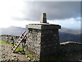
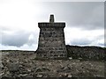
Sadly Slieve Donard passage tomb (which was originally some 40 meters in diameter) has been greatly robbed of its covering cairn and nothing at all remains of its chamber.
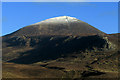
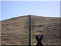
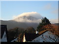
However the views from here are spectacular, and with the clouds wisping around you it truly feels like being on top of the world. A second Bronze Age cairn lies a couple of hundred meters away. Access is a pretty arduous uphill trek from Donard car park along the Glen River until one reaches the Mourne wall, then follow the wall to the left to reach the peak of Slieve Donard. Following the wall to the right will take you to the summit of Ulster's second highest mountain Slieve Commedagh. A small cairn is visible on its summit too.
You may be viewing yesterday's version of this page. To see the most up to date information please register for a free account.
")
")
Do not use the above information on other web sites or publications without permission of the contributor.
Nearby Images from Geograph Britain and Ireland:
©2022(licence)
©2009(licence)
©2009(licence)
©2018(licence)
©2014(licence)
The above images may not be of the site on this page, they are loaded from Geograph.
Please Submit an Image of this site or go out and take one for us!
Click here to see more info for this site
Nearby sites
Click here to view sites on an interactive map of the areaKey: Red: member's photo, Blue: 3rd party photo, Yellow: other image, Green: no photo - please go there and take one, Grey: site destroyed
Download sites to:
KML (Google Earth)
GPX (GPS waypoints)
CSV (Garmin/Navman)
CSV (Excel)
To unlock full downloads you need to sign up as a Contributory Member. Otherwise downloads are limited to 50 sites.
Turn off the page maps and other distractions
Nearby sites listing. In the following links * = Image available
3.5km NNE 22° Newcastle Stone Circle Stone Circle (J370310)
5.7km NW 317° King's Grave in Tollymore Forest* Cairn (J318317)
7.3km NNE 28° Wateresk Stone* Standing Stone (Menhir)
7.3km NNE 29° Ballyloughin Standing Stones (J392342)
7.6km NNE 30° Wateresk Dolmen* Portal Tomb (J3936234386)
7.8km S 185° The Longstone (Co. Down)* Standing Stone (Menhir)
7.9km NW 325° Drumena* Stone Fort or Dun (J3111034018)
10.7km SW 222° Moyard Court Tomb Chambered Tomb
11.8km WNW 288° Goward* Portal Tomb (J244310)
13.7km SSW 203° Kilkeel* Portal Tomb (J307149)
14.4km SSW 210° Dunnaman* Court Tomb
16.0km NNW 342° Legananny Cross Stone* Ancient Cross (J304428)
16.1km NW 321° Moneyslane* Standing Stones
16.7km W 270° Mullaghmore (Co. Down)* Stone Circle (J191272)
17.1km NNW 338° Legananny* Portal Tomb (J2886743397)
17.6km SW 227° Kilfeaghan* Portal Tomb (J232154)
17.6km NE 46° Ballynoe* Stone Circle (J4812740378)
19.2km WSW 239° St Bronagh's Graveyard (Kilbroney)* Ancient Cross (J195174)
19.3km WNW 288° Barnmeen* Standing Stone (Menhir) (J172330)
19.5km NNE 23° Annadorn Dolmen (Loughinisland)* Chambered Tomb (NW52870072)
20.2km WNW 302° Knockiveagh* Cairn
20.6km W 263° Tamnaharry* Standing Stone (Menhir)
21.0km NE 38° Down County Museum* Museum
21.1km W 267° Edenmore Court Tomb (J14752583)
21.1km NE 38° Mound of Down* Misc. Earthwork
View more nearby sites and additional images


 We would like to know more about this location. Please feel free to add a brief description and any relevant information in your own language.
 Wir möchten mehr über diese Stätte erfahren. Bitte zögern Sie nicht, eine kurze Beschreibung und relevante Informationen in Deutsch hinzuzufügen.
 Nous aimerions en savoir encore un peu sur les lieux. S'il vous plaît n'hesitez pas à ajouter une courte description et tous les renseignements pertinents dans votre propre langue.
 Quisieramos informarnos un poco más de las lugares. No dude en añadir una breve descripción y otros datos relevantes en su propio idioma.