

<< Our Photo Pages >> Grobowce Megalityczne Muszkowice - Long Barrow in Poland in Dolnoslaskie
Submitted by marasch on Thursday, 14 February 2013 Page Views: 3115
Neolithic and Bronze AgeSite Name: Grobowce Megalityczne Muszkowice Alternative Name: Kompleks megalityczny w Muszkowicach, Muszkowice megalithic complexCountry: Poland
NOTE: This site is 7.792 km away from the location you searched for.
Voivodeship: Dolnoslaskie Type: Long Barrow
Nearest Town: Ciepłowody Nearest Village: Muszkowice
Latitude: 50.649898N Longitude: 16.939790E
Condition:
| 5 | Perfect |
| 4 | Almost Perfect |
| 3 | Reasonable but with some damage |
| 2 | Ruined but still recognisable as an ancient site |
| 1 | Pretty much destroyed, possibly visible as crop marks |
| 0 | No data. |
| -1 | Completely destroyed |
| 5 | Superb |
| 4 | Good |
| 3 | Ordinary |
| 2 | Not Good |
| 1 | Awful |
| 0 | No data. |
| 5 | Can be driven to, probably with disabled access |
| 4 | Short walk on a footpath |
| 3 | Requiring a bit more of a walk |
| 2 | A long walk |
| 1 | In the middle of nowhere, a nightmare to find |
| 0 | No data. |
| 5 | co-ordinates taken by GPS or official recorded co-ordinates |
| 4 | co-ordinates scaled from a detailed map |
| 3 | co-ordinates scaled from a bad map |
| 2 | co-ordinates of the nearest village |
| 1 | co-ordinates of the nearest town |
| 0 | no data |
Internal Links:
External Links:
I have visited· I would like to visit
SolarMegalith visited on 3rd Oct 2018 - their rating: Cond: 3 Amb: 5 Access: 3
")
“Non-invasive Archaeological Prospection of the Neolithic Earthen Long Barrows Complex in the Muszkowice Forest”, co-funded in 2012 by the Polish Ministry of Culture and National Heritage within the Cultural Heritage programme priority "Protection of the Archaeological Sites" (coordinated by Nationa Heritage Board of Poland).
Megalithic Complex in the Muszkowice Forest
Additional information from SolarMegalith:
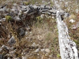
Long barrow 1 – 50.650507, 16.939044. One of the largest long barrows of the group, it was partly excavated. Some large stone blocks are visible in its NW part.
Long barrow 2 – 50.650225, 16.939833. A short long barrow.
Long barrow 3 – 50.650194, 16.940198.
Long barrow 4 – 50.65005, 16.939818. A well-preserved long barrow with some large boulders still visible near its edges.
Long barrow 5 – 50.649898, 16.93979. Another well-preserved long barrow with some boulders visible at its southern edge.
Long barrow 6 – 50.64983, 16.939149. A large long barrow with several boulders visible at its eastern terminal.
You may be viewing yesterday's version of this page. To see the most up to date information please register for a free account.
")
")
")
")
")
")
")
")
Do not use the above information on other web sites or publications without permission of the contributor.
Click here to see more info for this site
Nearby sites
Click here to view sites on an interactive map of the areaKey: Red: member's photo, Blue: 3rd party photo, Yellow: other image, Green: no photo - please go there and take one, Grey: site destroyed
Download sites to:
KML (Google Earth)
GPX (GPS waypoints)
CSV (Garmin/Navman)
CSV (Excel)
To unlock full downloads you need to sign up as a Contributory Member. Otherwise downloads are limited to 50 sites.
Turn off the page maps and other distractions
Nearby sites listing. In the following links * = Image available
306m SW 234° Kurhany Muszkowice (2)* Barrow Cemetery
689m ESE 107° Kurhany Muszkowice (3)* Barrow Cemetery
2.0km SW 220° Kurhany Muszkowice (1)* Barrow Cemetery
15.4km NW 325° Grodzisko Przystronie Promontory Fort / Cliff Castle
19.1km E 91° Grodzisko Jagielnica* Hillfort
29.0km NNW 328° Niedźwiedź i Panna z Rybą* Sculptured Stone
30.4km NNW 332° Sobótka Mnich II* Sculptured Stone
31.0km NNW 334° Sobótka sculptered stone I* Sculptured Stone
32.7km N 1° Kurhan Kuklice Round Barrow(s)
33.5km SSW 195° Jaskinia Radochowska Cave or Rock Shelter
37.8km N 2° Grodzisko Magnice Hillfort
44.5km NE 49° Grodzisko Lipki* Hillfort
45.0km NE 47° Grodzisko Ryczyn Mały* Hillfort
45.2km NE 47° Grodzisko Ryczyn Wielki* Hillfort
46.9km NW 307° Grodzisko Nowy Jaworów* Hillfort
52.9km WNW 295° Krzyż Pokutny Cisów* Ancient Cross
56.2km N 4° Grodzisko Góra Kapliczna - Osobowice* Hillfort
56.7km N 3° Grodzisko Szwedzki Szaniec - Osobowice* Hillfort
58.7km ESE 109° Grodzisko Chrzelice Hillfort
59.8km NNE 24° Kurhany Oleśniczka* Barrow Cemetery
65.5km NW 319° Grodzisko Mierczyce* Hillfort
70.7km N 0° Kurhany Oborniki Slaskie (1)* Round Barrow(s)
71.7km N 1° Grodzisko Oborniki Śląskie* Hillfort
74.1km N 357° Kurhany Oborniki Slaskie (2)* Round Barrow(s)
77.2km E 88° Grodzisko Lędziny Hillfort
View more nearby sites and additional images


 We would like to know more about this location. Please feel free to add a brief description and any relevant information in your own language.
 Wir möchten mehr über diese Stätte erfahren. Bitte zögern Sie nicht, eine kurze Beschreibung und relevante Informationen in Deutsch hinzuzufügen.
 Nous aimerions en savoir encore un peu sur les lieux. S'il vous plaît n'hesitez pas à ajouter une courte description et tous les renseignements pertinents dans votre propre langue.
 Quisieramos informarnos un poco más de las lugares. No dude en añadir una breve descripción y otros datos relevantes en su propio idioma.