
, Aubrey Burl")
<< Our Photo Pages >> Klokkersteinen runestone - Carving in Norway in Nord-Trøndelag
Submitted by kenntha88 on Friday, 14 September 2012 Page Views: 1802
Early Medieval (Dark Age)Site Name: Klokkersteinen runestone Alternative Name: PåssåhaugenCountry: Norway Fylke: Nord-Trøndelag Type: Carving
Nearest Town: Trondheim Nearest Village: Levanger
Latitude: 63.799418N Longitude: 11.134890E
Condition:
| 5 | Perfect |
| 4 | Almost Perfect |
| 3 | Reasonable but with some damage |
| 2 | Ruined but still recognisable as an ancient site |
| 1 | Pretty much destroyed, possibly visible as crop marks |
| 0 | No data. |
| -1 | Completely destroyed |
| 5 | Superb |
| 4 | Good |
| 3 | Ordinary |
| 2 | Not Good |
| 1 | Awful |
| 0 | No data. |
| 5 | Can be driven to, probably with disabled access |
| 4 | Short walk on a footpath |
| 3 | Requiring a bit more of a walk |
| 2 | A long walk |
| 1 | In the middle of nowhere, a nightmare to find |
| 0 | No data. |
| 5 | co-ordinates taken by GPS or official recorded co-ordinates |
| 4 | co-ordinates scaled from a detailed map |
| 3 | co-ordinates scaled from a bad map |
| 2 | co-ordinates of the nearest village |
| 1 | co-ordinates of the nearest town |
| 0 | no data |
Internal Links:
External Links:
")
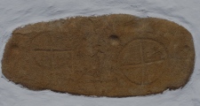
On a small cairn on a flat space on the ytterøya island is a runestone. It stands on a spot where there previously were several barrows and cairns. Today, the only remains is the Klokkersteinen runestone and a small round barrow with a standing stone on top around 500 metres to the east. The cairn under the stone is not visible today, it has probably been lost during work on the country road just next to it.
The runes on klokkersteinen is very hard to decipher. They are only 5 runes that is possible to read out of 10 runes. They are very eroded and almost not visible. They have been interpreted as the start of a name or a word meaning "Påsså..."
The stone is around 2 metres in height, around 1 metre wide at the base and around 30cm wide, the top ends in a sharp point. It has a triangular shape.
The stone has another very interesting feature, on the flat edge at the same side of the runic inscription is 7 small cup-markings. They are most known from bronze age rock art. Maybe the stone is older then the runes and the inscription has been added later?
You may be viewing yesterday's version of this page. To see the most up to date information please register for a free account.
")
")
")
")
")
")
Do not use the above information on other web sites or publications without permission of the contributor.
Click here to see more info for this site
Nearby sites
Click here to view sites on an interactive map of the areaKey: Red: member's photo, Blue: 3rd party photo, Yellow: other image, Green: no photo - please go there and take one, Grey: site destroyed
Download sites to:
KML (Google Earth)
GPX (GPS waypoints)
CSV (Garmin/Navman)
CSV (Excel)
To unlock full downloads you need to sign up as a Contributory Member. Otherwise downloads are limited to 50 sites.
Turn off the page maps and other distractions
Nearby sites listing. In the following links * = Image available
745m ENE 67° Eid standing stone* Standing Stone (Menhir)
4.2km ENE 67° Eines Barrow Cemetery* Barrow Cemetery
8.3km SE 127° Kjønstad-Vestre* Barrow Cemetery
8.7km SE 130° Gjemble Lille* Round Barrow(s)
8.7km NNW 328° Kvennavika Rock Carvings* Rock Art
8.8km SE 135° Kleivstuvegen* Barrow Cemetery
8.8km NNE 31° Hjulstad* Standing Stone (Menhir)
8.8km SE 136° Vekre Vestre* Round Barrow(s)
8.8km SSE 146° Eidsbotnvegen* Barrow Cemetery
9.3km SSE 151° Alvshaugen* Round Barrow(s)
9.8km SSE 150° Brødrehaugene* Round Barrow(s)
10.0km ENE 60° Sørvika-Grøtneset* Cairn
10.0km ENE 58° Vikamarka-Grøtneset* Cist
10.1km SSE 157° Nøysomhet* Round Barrow(s)
10.4km S 179° Laberget Cairns* Cairn
10.4km SSE 160° Støre-Jonsborg* Round Barrow(s)
10.5km ESE 109° Børøya-Storborg* Barrow Cemetery
10.6km SSE 155° Ølvstuggu* Cairn
10.7km SSE 160° Jonsborg Nedre* Barrow Cemetery
10.8km NE 42° Vangsåkern* Standing Stone (Menhir)
10.9km ESE 118° Røstad Øvre* Barrow Cemetery
11.0km NE 53° Roel Hynne* Round Barrow(s)
11.2km SE 135° Halstein* Hillfort
11.2km SSE 157° Øversand Med Stavlo Nedre* Cairn
11.2km SE 127° Geite Barrow Cemetery* Barrow Cemetery
View more nearby sites and additional images


 We would like to know more about this location. Please feel free to add a brief description and any relevant information in your own language.
 Wir möchten mehr über diese Stätte erfahren. Bitte zögern Sie nicht, eine kurze Beschreibung und relevante Informationen in Deutsch hinzuzufügen.
 Nous aimerions en savoir encore un peu sur les lieux. S'il vous plaît n'hesitez pas à ajouter une courte description et tous les renseignements pertinents dans votre propre langue.
 Quisieramos informarnos un poco más de las lugares. No dude en añadir una breve descripción y otros datos relevantes en su propio idioma.