<< Our Photo Pages >> Gainford Spa - Holy Well or Sacred Spring in England in County Durham
Submitted by durhamnature on Saturday, 21 July 2012 Page Views: 9567
Springs and Holy WellsSite Name: Gainford SpaCountry: England County: County Durham Type: Holy Well or Sacred Spring
Nearest Town: Darlington Nearest Village: Gainford
Map Ref: NZ16131738
Latitude: 54.551415N Longitude: 1.75214W
Condition:
| 5 | Perfect |
| 4 | Almost Perfect |
| 3 | Reasonable but with some damage |
| 2 | Ruined but still recognisable as an ancient site |
| 1 | Pretty much destroyed, possibly visible as crop marks |
| 0 | No data. |
| -1 | Completely destroyed |
| 5 | Superb |
| 4 | Good |
| 3 | Ordinary |
| 2 | Not Good |
| 1 | Awful |
| 0 | No data. |
| 5 | Can be driven to, probably with disabled access |
| 4 | Short walk on a footpath |
| 3 | Requiring a bit more of a walk |
| 2 | A long walk |
| 1 | In the middle of nowhere, a nightmare to find |
| 0 | No data. |
| 5 | co-ordinates taken by GPS or official recorded co-ordinates |
| 4 | co-ordinates scaled from a detailed map |
| 3 | co-ordinates scaled from a bad map |
| 2 | co-ordinates of the nearest village |
| 1 | co-ordinates of the nearest town |
| 0 | no data |
Internal Links:
External Links:
I have visited· I would like to visit
Darrenci would like to visit
")
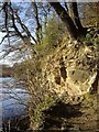
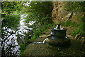
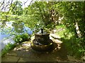
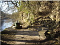
Gainford Spa, a sulphurous spring on the wooded banks of the River Tees. It was first formalised around 1830, when there was a vogue for medicinal springs, but never took off as a serious tourist attraction, despite its beautiful setting. The current spring head fountain is a tasteful 2002 reconstruction of a 19th century one, which had been vandalised.
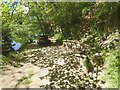
Access is by a footpath from the western end of Gainford village, on a slightly steep path through the woods.
The water is quite forceful, quite cold and has a sulphur taste and smell, not too strong.
You may be viewing yesterday's version of this page. To see the most up to date information please register for a free account.
")
")
Do not use the above information on other web sites or publications without permission of the contributor.
Nearby Images from Geograph Britain and Ireland:
©2010(licence)
©2019(licence)
©2005(licence)
©2019(licence)
©2010(licence)
The above images may not be of the site on this page, they are loaded from Geograph.
Please Submit an Image of this site or go out and take one for us!
Click here to see more info for this site
Nearby sites
Key: Red: member's photo, Blue: 3rd party photo, Yellow: other image, Green: no photo - please go there and take one, Grey: site destroyed
Download sites to:
KML (Google Earth)
GPX (GPS waypoints)
CSV (Garmin/Navman)
CSV (Excel)
To unlock full downloads you need to sign up as a Contributory Member. Otherwise downloads are limited to 50 sites.
Turn off the page maps and other distractions
Nearby sites listing. In the following links * = Image available
1.0km SE 132° St. Mary's Well (Gainford)* Holy Well or Sacred Spring (NZ169167)
1.1km ESE 116° Gainford Stone* Rock Art (NZ1708016920)
1.7km W 279° Winston Station Rock Art (NZ1445017650)
2.1km WSW 244° Winston Shap Erratic* Natural Stone / Erratic / Other Natural Feature (NZ14251645)
4.4km WNW 287° Cleatlam Wayside Cross* Ancient Cross (NZ1189318683)
4.5km NW 317° St Mary The Virgin, Staindrop* Ancient Cross (NZ13082064)
4.6km SW 233° Cockshot Camp* Hillfort (NZ12491458)
5.1km SSE 162° St Cuthbert (Forcett)* Ancient Cross (NZ177125)
5.2km ESE 115° Howe Hill (Piercebridge)* Round Barrow(s) (NZ20881515)
5.3km ESE 114° Betty Watson's Hill* Round Barrow(s) (NZ21041526)
5.4km SSE 162° Stanwick Hillfort* Hillfort (NZ17831229)
5.4km SW 236° St Mary's Church (Wycliffe)* Ancient Cross (NZ1167314325)
5.9km ESE 104° Smotherlaw Barrow* Round Barrow(s) (NZ21881601)
5.9km SSE 156° Stanwick Crosses* Ancient Cross (NZ18511198)
6.0km SSE 155° Kirkbridge Farmhouse Barrow* Round Barrow(s) (NZ187120)
6.8km ESE 109° St Edwin's (High Coniscliffe)* Ancient Cross (NZ2257815234)
6.9km NE 42° Legg's Cross* Ancient Cross (NZ20712249)
7.6km WSW 245° The Mortham Stones Natural Stone / Erratic / Other Natural Feature (NZ09251415)
8.3km WSW 238° Greta Bridge Roman Site Rock Art (NZ0905012950)
8.9km S 185° Mainsgill Farm* Modern Stone Circle etc (NZ154085)
9.0km NE 49° Shackleton Beacon* Hillfort (NZ22952331)
9.4km SSW 203° The Dalton Stone Rock Art (NZ1240008700)
9.9km WSW 238° St Mary's Old Church (Brignall)* Ancient Cross (NZ0772412196)
10.0km SSW 208° Dalton Portable 1 & 2 Rock Art (NZ1150008500)
10.2km WSW 240° St. Mary's Church (Brignall)* Ancient Cross (NZ0725712313)
View more nearby sites and additional images


 We would like to know more about this location. Please feel free to add a brief description and any relevant information in your own language.
 Wir möchten mehr über diese Stätte erfahren. Bitte zögern Sie nicht, eine kurze Beschreibung und relevante Informationen in Deutsch hinzuzufügen.
 Nous aimerions en savoir encore un peu sur les lieux. S'il vous plaît n'hesitez pas à ajouter une courte description et tous les renseignements pertinents dans votre propre langue.
 Quisieramos informarnos un poco más de las lugares. No dude en añadir una breve descripción y otros datos relevantes en su propio idioma.