 with our Megalithic Portal iPhone app")

<< Our Photo Pages >> Dunan Aula - Cist in Scotland in Argyll
Submitted by caradoc68 on Friday, 16 March 2012 Page Views: 3957
Neolithic and Bronze AgeSite Name: Dunan Aula Alternative Name: BarbreckCountry: Scotland County: Argyll Type: Cist
Nearest Town: Lochgilphead
Map Ref: NM83420697
Latitude: 56.205886N Longitude: 5.493518W
Condition:
| 5 | Perfect |
| 4 | Almost Perfect |
| 3 | Reasonable but with some damage |
| 2 | Ruined but still recognisable as an ancient site |
| 1 | Pretty much destroyed, possibly visible as crop marks |
| 0 | No data. |
| -1 | Completely destroyed |
| 5 | Superb |
| 4 | Good |
| 3 | Ordinary |
| 2 | Not Good |
| 1 | Awful |
| 0 | No data. |
| 5 | Can be driven to, probably with disabled access |
| 4 | Short walk on a footpath |
| 3 | Requiring a bit more of a walk |
| 2 | A long walk |
| 1 | In the middle of nowhere, a nightmare to find |
| 0 | No data. |
| 5 | co-ordinates taken by GPS or official recorded co-ordinates |
| 4 | co-ordinates scaled from a detailed map |
| 3 | co-ordinates scaled from a bad map |
| 2 | co-ordinates of the nearest village |
| 1 | co-ordinates of the nearest town |
| 0 | no data |
Internal Links:
External Links:
")
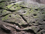
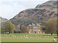
There is an exposed cist, said to have been "covered by loose stones" when found at some time prior to 1793, situated north of the mausoleum in the late 18th century family burial ground which stands on the summit of a large steep-sided mound. The Statistical Account (OSA 1793) records an "urn with ahses" being found by workmen when the mausoleum was being built. The cist measures 4' by 2'7" by 2'9". The gable capstone measures 5'4" by 4'8". Other stones projecting from the sides of the mound suggest that other graves may exist undamaged.
M Campbell and M Sandeman 1964; OSA 1793; M Campbell 1956; SDD 1960-.
As described. There is no trace of any cairn material. 10 metres to WNW is an upright slab which appears to be neither part of a kerb nor part of a cist. It is 1 metre high, 0.4 metres thick and 0.6 metres broad. Surveyed at 1:2500 scale.
Visited by OS (D W R) 6 October 1971.
Set into the top of Dunan Aula, a natural knoll situated 650m NNE of barbreck House, and a little to the N of the mausoleum, there is a massive cist constructed of four large slabs and a gabled capstone; aligned NE and SW, it measures 1.2m by 0.7m and 0.8m in depth internally. In the later 18th century the cist was broken into and an 'urn' and cremated remains were discovered (OSA 1797); the urn was destroyed.
About 9.5m to the NNW, on the side of the knoll, there is an upright slab, which is aligned NW and SE and measures 0.6m by 0.4m at the base and 1m in height; it has straightish sides and a flat top.
Visited May 1982
RCAHMS 1988
You may be viewing yesterday's version of this page. To see the most up to date information please register for a free account.
")
")
")
")
Do not use the above information on other web sites or publications without permission of the contributor.
Nearby Images from Geograph Britain and Ireland:
©2006(licence)
©2014(licence)
©2009(licence)
©2009(licence)
©2012(licence)
The above images may not be of the site on this page, they are loaded from Geograph.
Please Submit an Image of this site or go out and take one for us!
Click here to see more info for this site
Nearby sites
Key: Red: member's photo, Blue: 3rd party photo, Yellow: other image, Green: no photo - please go there and take one, Grey: site destroyed
Download sites to:
KML (Google Earth)
GPX (GPS waypoints)
CSV (Garmin/Navman)
CSV (Excel)
To unlock full downloads you need to sign up as a Contributory Member. Otherwise downloads are limited to 50 sites.
Turn off the page maps and other distractions
Nearby sites listing. In the following links * = Image available
647m SSW 204° Barbreck* Standing Stones (NM83130639)
863m NE 43° Sluggan Standing Stone* Standing Stone (Menhir) (NM8404207571)
878m NNE 33° Sluggan Cairn* Cairn (NM83940768)
1.3km SW 230° Barbreck Well* Holy Well or Sacred Spring (NM824062)
1.9km S 184° The Watch Stone (Kintraw)* Standing Stone (Menhir) (NM83200509)
1.9km S 185° Kintraw hill platform* Cairn (NM83170507)
2.0km S 188° Kintraw (Kilmartin)* Standing Stone (Menhir) (NM83050497)
2.1km S 169° Dun Na Ban-Oige* Stone Fort or Dun (NM837049)
2.2km S 183° Kintraw (Argyll) Stone Fort or Dun (NM832048)
2.2km ESE 116° Tur A' Bhodaich Stone Fort or Dun (NM854059)
2.8km SW 222° Eilean Carnaich* Cairn (NM81450501)
3.0km S 185° Bealoch Mor Stone Circle (NM8304)
3.0km SSE 165° Salachary* Stone Row / Alignment (NM8405604024)
3.3km SW 230° Beinn An Duin* Stone Fort or Dun (NM80790499)
3.3km SSW 193° Lochan Druim An Rathaid Cairn (NM825038)
3.3km W 280° Caisteal Nan Coin Dubh Stone* Standing Stone (Menhir) (NM8014907733)
3.5km W 278° Caisteal Nan Coin Dubh (Craobh Haven)* Hillfort (NM80000762)
3.5km W 276° Caisteal Nan Coin Dubh Cairn* Cairn (NM7993107519)
3.7km ESE 123° Dun Dubh Stone Fort or Dun (NM864048)
3.7km SW 226° Clach An T-Sagairt* Chambered Tomb (NM80630451)
3.9km SE 146° Dun Chonallaich* Stone Fort or Dun (NM85440365)
4.2km W 281° Eilean An Dùin* Vitrified Fort (NM7929407959)
4.4km SSE 157° Dun Na Nighinn Stone Fort or Dun (NM84910282)
4.5km SSW 193° Ormaig* Rock Art (NM82220267)
4.9km SE 132° Ford Cist* Cist (NM86890356)
View more nearby sites and additional images


 We would like to know more about this location. Please feel free to add a brief description and any relevant information in your own language.
 Wir möchten mehr über diese Stätte erfahren. Bitte zögern Sie nicht, eine kurze Beschreibung und relevante Informationen in Deutsch hinzuzufügen.
 Nous aimerions en savoir encore un peu sur les lieux. S'il vous plaît n'hesitez pas à ajouter une courte description et tous les renseignements pertinents dans votre propre langue.
 Quisieramos informarnos un poco más de las lugares. No dude en añadir una breve descripción y otros datos relevantes en su propio idioma.