Featured: Lost Secrets - an adventure during Neolithic times

Lost Secrets - an adventure during Neolithic times

See Your Book Here

See Your Book Here

Who's Online

There are currently, 465 guests and 3 members online.

You are a guest. To join in, please register for free by clicking here

Sponsors

<< Our Photo Pages >> Karum Kanes - Ancient Village or Settlement in Turkey

Submitted by davidmorgan on Saturday, 17 October 2015  Page Views: 5857

Multi-periodSite Name: Karum Kanes Alternative Name: Kârum Kaneš, Kanesh
Country: Turkey Type: Ancient Village or Settlement
Nearest Town: Kayseri
Latitude: 38.853395N  Longitude: 35.639151E
Condition:
5Perfect
4Almost Perfect
3Reasonable but with some damage
2Ruined but still recognisable as an ancient site
1Pretty much destroyed, possibly visible as crop marks
0No data.
-1Completely destroyed
2 Ambience:
5Superb
4Good
3Ordinary
2Not Good
1Awful
0No data.
4 Access:
5Can be driven to, probably with disabled access
4Short walk on a footpath
3Requiring a bit more of a walk
2A long walk
1In the middle of nowhere, a nightmare to find
0No data.
4 Accuracy:
5co-ordinates taken by GPS or official recorded co-ordinates
4co-ordinates scaled from a detailed map
3co-ordinates scaled from a bad map
2co-ordinates of the nearest village
1co-ordinates of the nearest town
0no data
5

Internal Links:
External Links:

Karum Kanes
Karum Kanes submitted by davidmorgan : The remains of a 1900 BCE Assyrian trade colony in Anatolia. (Vote or comment on this photo)
Kârum Kaneš was an early 2nd millennium BCE Assyrian trade colony in Kayseri Province, Turkey (Anatolia). During the Bronze Age in this region, the Kârum was a portion of the city set aside by local officials for the early Assyrian merchants to use without paying taxes, as long as the goods remained inside the kârum.

The term kârum means "port" in Akkadian, the lingua franca of the time, although it was extended to refer to any trading colony whether it bordered water or not. Several other cities in Anatolia also had kârum, but the largest was Kaneš. This important kârum was inhabited by merchants from Assyria for hundreds of years, who traded local tin and wool for luxury items, foodstuffs and spices, and, woven fabrics from the Assyrian homeland and from Elam.

Note: The 4000 year old ancient trade tablets of Kültepe have been accepted into the UNESCO Memory of the World Register, see the comments on our page for more details
You may be viewing yesterday's version of this page. To see the most up to date information please register for a free account.

Karum Kanes
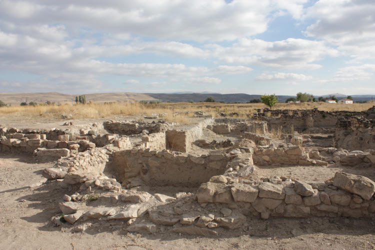
Karum Kanes submitted by davidmorgan : Ancient Assyrian traders lived here. (Vote or comment on this photo)

Karum Kanes
Karum Kanes submitted by davidmorgan : An oven. (Vote or comment on this photo)

Karum Kanes
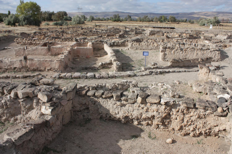
Karum Kanes submitted by davidmorgan : Level IB - 1800-1750 BCE. (Vote or comment on this photo)

Karum Kanes
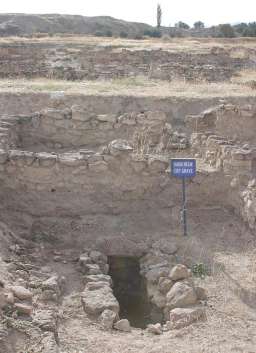
Karum Kanes submitted by davidmorgan : A cist grave. (Vote or comment on this photo)

Do not use the above information on other web sites or publications without permission of the contributor.

Nearby Images from Flickr
Kltepe
Kltepe
Kltepe
Kltepe
Railway
Karahyk

The above images may not be of the site on this page, but were taken nearby. They are loaded from Flickr so please click on them for image credits.


Click here to see more info for this site

Nearby sites

Click here to view sites on an interactive map of the area

Key: Red: member's photo, Blue: 3rd party photo, Yellow: other image, Green: no photo - please go there and take one, Grey: site destroyed

Download sites to:
KML (Google Earth)
GPX (GPS waypoints)
CSV (Garmin/Navman)
CSV (Excel)

To unlock full downloads you need to sign up as a Contributory Member. Otherwise downloads are limited to 50 sites.


Turn off the page maps and other distractions

Nearby sites listing. In the following links * = Image available
 428m SW 229° Kültepe Kanes* Ancient Village or Settlement
 19.7km SW 222° Kayseri Archaeological Museum* Museum
 25.9km ENE 58° Sultan Hani Stele* Rock Art
 39.0km WSW 244° Örenşehir* Ancient Village or Settlement
 65.0km S 181° Fraktin* Carving
 71.4km WSW 253° Rock Cones of Urgup (Cappadocia)* Natural Stone / Erratic / Other Natural Feature
 72.0km SSE 159° Imamkullu* Carving
 72.4km WNW 284° Topakli Hoyuk Ancient Village or Settlement
 72.7km SW 234° Sobessos* Ancient Village or Settlement
 74.9km NNW 342° Sarikaya Roman Bath* Ancient Village or Settlement
 78.3km SSE 155° Gezbeli* Carving
 83.5km SE 134° Comana Chryse* Ancient Village or Settlement
 84.3km WSW 252° Nevsehir Underground City* Cave or Rock Shelter
 88.6km WSW 241° Kaymakli Underground City* Ancient Village or Settlement
 89.0km W 263° Arapsun* Ancient Village or Settlement
 89.8km NNW 339° Alisar Hoyuk* Ancient Village or Settlement
 94.7km E 87° Karakuyu Hittite Dam* Ancient Mine, Quarry or other Industry
 95.0km SW 236° Derinkuyu Underground City* Ancient Village or Settlement
 101.0km NNW 335° Cadir Hoyuk* Ancient Village or Settlement
 102.6km W 272° Karaburna* Carving
 108.3km WSW 249° Topada* Carving
 108.9km NNW 347° Karakiz* Carving
 111.5km NNW 334° Kerkenes Ancient Village or Settlement
 114.5km NE 42° Kayalipinar Ancient Village or Settlement
 115.4km SW 235° Golludag* Ancient Village or Settlement
View more nearby sites and additional images

<< Monte Elva Nuraghe

Soar Stone >>

Please add your thoughts on this site

Cornwall in Prehistory

Cornwall in Prehistory

Sponsors

Auto-Translation (Google)

Translate from English into:

"Karum Kanes" | Login/Create an Account | 4 News and Comments
  
Go back to top of page    Comments are owned by the poster. We aren't responsible for their content.
Kültepe ancient trade tablets added to UNESCO Memory of the World Register by davidmorgan on Saturday, 17 October 2015
(User Info | Send a Message)
The Kültepe Tablets, the earliest written documentation of life in Anatolia, have been included in the UNESCO Memory of the World Register.

The Old Assyrian merchant archives consisting of ca 23,500 tablets from Kültepe form a unique textual corpus in world history. The trade is documented in great detail through the archives, alongside the daily intricacies of the families and their commercial and private dealings with the local population.

At a press conference held on Oct. 16 at the Kayseri Archaeology Museum, Kayseri Governor Orhan Düzgün said Profesor Fikri Kulakoğlu had applied for the inclusion of Kültepe in the Memory of the World Register, with the initiative of the Kültepe excavation head.

“In this way, Kayseri will draw the attention of people interested in history and culture. We believe that the number of visitors will increase at the ancient site of Kültepe where these tablets were found and the Kayseri Museum where they are on display,” the governor said.

Düzgün said the artifacts would be moved to the new archaeology museum, which is under construction inside the Kayseri Castle, in 2016. “The new museum will have a more contemporary style,” he added.

Kayseri Mayor Mustafa Çelik said the geography of Kayseri had a history of 5,000 years, adding, “The genetic codes of our business mind are written on these tablets.”

Kulakoğlu said the existence of the ancient clay tablets distinguished Kayseri from other cities, as the “richest part of Anatolia” had been found there. “The people of Anatolia learned how to read and write in Kültepe,” he said, adding that the site had contributed many artifacts to museums in other cities, such as Ankara Museum of Anatolian Civilizations and the Istanbul Archeology Museum. Regarding the clay tablets, he said, “The tablets have information about the activities of ancient traders. They shed light not only on Anatolian history but also on the history of Mesopotamia and Syria. Everything money-related are on these tablets.”

Source: Hürriyet
[ Reply to This ]

4,000-year-old tablets found in Turkey include women’s rights by davidmorgan on Sunday, 19 July 2015
(User Info | Send a Message)
The Kültepe-Kaniş-Karum trade colony in the Central Anatolian province of Kayseri continues to amaze archeologists, with an expert at the dig revealing that tablets citing women’s rights were discovered at the Bronze Age settlement.

Excavations at the ancient tumulus site began in 1948. So far, it has been discovered the center was where the written history of Anatolia began and the largest monumental structure of the Middle East was unearthed in 2013. A centuries-old baby rattle and a tablet about the sale of a donkey were unearthed last year.

Last month, the 2015 excavation season began in Kültepe. The head of the excavation team, Prof. Fikri Kulakoğlu of Ankara University, told Doğan News Agency on July 16 the site was remarkable not only because the priceless tablets revealed commercial information about the Assyrians, but also about the local social life of the time with all kinds of personal details about individuals.

“From women’s rights to the adoption of children and marriages arranged at birth, the tablets include all kinds of civilizational and social data from Anatolia 4,000 years ago. There is also an emotional letter from a woman to her husband and a letter from another woman who complains about her mother-in-law. You can’t find such things in an empire’s official archive,” he said.

Still, most of the 23,500 cuneiform tablets unearthed at Kültepe were about commerce. “Kültepe is where the Anatolian enlightenment began. The people in this area were literate much earlier than other places in Anatolia, including its west,” Kulakoğlu added.

Some 90 percent of the Kültepe tablets can be seen in the Museum of Anatolian Civilizations in Ankara. Some of them are exhibited at the site and are expected to be transferred soon to a new archaeology museum under construction in Kayseri, deemed to be the most important museum of the historic Cappadocia region.

“This is a huge wealth,” Kulakoğlu said, voicing his hope that the trade colony will soon be included in the UNESCO World Heritage List.

The settlement in the tumulus is composed of segments from the early Bronze Age, the middle Bronze Age, the Iron Age and Ancient Greece and Rome.

One of the most important discoveries was a tablet from 2000 B.C., which explains there were local kingdoms in Anatolia at that time and the Kaniş Kingdom was the most powerful one.

Only a small area of Kültepe, which is thought to have hosted over 70,000 people four millennia ago, has been excavated so far. Officials say it might take 5,000 years to excavate the entire ancient site.

Source: Hürriyet
[ Reply to This ]

Kültepe digs may reveal new written documents by davidmorgan on Tuesday, 25 June 2013
(User Info | Send a Message)
This year the Kültepe archaeological excavations will once again continue in Kayseri. The head of the excavations says the works will particularly focus on an area from the Bronze Age.

The archaeological excavations that started in 1948 at the Karum tumulus of the Kültepe/Kaniş province of the central province of Kayseri are still ongoing around 20 kilometers from the Kayseri-Sivas highway. The head of the Kültepe excavations, Professor Fikri Kulakoğlu, told Anatolia news agency some details about the works. “We are planning to work in an area of the Bronze Age, about 5,000 years earlier than today. These studies will be held by a scientific committee consisting of 70 people,” Kulakoğlu.

He said the name “Kültepe” had been known since 1871, when the cuneiform tablet, known as the “Cappadocia Tablets,” were found. The first excavation in Kültepe was then led by Ernst Chantre from 1893 to 1894. Excavations continued with H. Winckler and H. Grothe in 1906.

Kulakoğlu said the excavations would continue in Karum (Down River), aiming to find traces from as many as 5,000 years ago. “We started our excavations on June 15. Karum has an importance of being the starting point of the Anatolian history, so the excavations need to be conducted even more carefully compared to other cities. In this year, we are planning an opening in the Karum area and the traces of 5,000 years ago from the Bronze Age will be examined. These studies will continue under the control of a scientific commission of 70 people and students from different universities will also join the excavations. The project will continue for three-and-a-half months. Our biggest aim in these studies is to find traces and tablets from earlier times in the Karum area,” he added.

The local municipality supports the excavations. “[Kayseri Mayor] Mehmet Özhaseki has some cultural tours that are beneficial for the introduction of the area, as much as his contributions to the cleaning and excavation of the area. Theater performances are also included in these culture tours. I am really grateful for their efforts because they are realizing activities that are unique in Turkey.”

Kulakoğlu said the changes occurring in Anatolia 5,000 years ago could be observed in the other tumulus and settled areas of Turkey, while on the other hand no other area in Turkey had information even dating back to 2000 B.C. “Besides, this information is not only about Turkey, but also enlightens the dark sides of neighboring countries’ histories,” he added, without elaborating.

The cuneiform writings of Kültepe are the oldest documents found in the Turkish lands. “For this reason, Kültepe is where Anatolian history begins. There are 25,000 cuneiform writings found in Kültepe up to now. The most important of these documents is the tablet from 2000 B.C., which explains that there were local kingdoms in Anatolia at that time and the Kaniş Kingdom was the most powerful local kingdom in Anatolia. Merchants from Asur, which is 1,000 kilometers away, came to Kaniş to use the natural sources of Anatolia,” explained Kulakoğlu.

The Kaniş, Karum and Kültepe area has a 550 meter diameter and 20 meter height. The settlement in the cumulus is composed of segments from the early Bronze Age, the middle Bronze Age, the Iron Age, and Ancient Greece and Rome.

Source: Hürriyet
[ Reply to This ]

Your Name: Anonymous [ Register Now ]
Subject:


Add your comment or contribution to this page. Spam or offensive posts are deleted immediately, don't even bother

<<< What is five plus one as a number? (Please type the answer to this question in the little box on the left)
You can also embed videos and other things. For Youtube please copy and paste the 'embed code'.
For Google Street View please include Street View in the text.
Create a web link like this: <a href="https://www.megalithic.co.uk">This is a link</a>  

Allowed HTML is:
<p> <b> <i> <a> <img> <em> <br> <strong> <blockquote> <tt> <li> <ol> <ul> <object> <param> <embed> <iframe>

We would like to know more about this location. Please feel free to add a brief description and any relevant information in your own language.
Wir möchten mehr über diese Stätte erfahren. Bitte zögern Sie nicht, eine kurze Beschreibung und relevante Informationen in Deutsch hinzuzufügen.
Nous aimerions en savoir encore un peu sur les lieux. S'il vous plaît n'hesitez pas à ajouter une courte description et tous les renseignements pertinents dans votre propre langue.
Quisieramos informarnos un poco más de las lugares. No dude en añadir una breve descripción y otros datos relevantes en su propio idioma.