

<< Our Photo Pages >> Helfensteine - Hillfort in Germany in Hesse
Submitted by KaiHofmann on Monday, 26 April 2010 Page Views: 3645
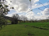
Iron Age and Later PrehistorySite Name: HelfensteineCountry: Germany Land: Hesse Type: Hillfort
Nearest Town: Kassel Nearest Village: Zierenberg
Latitude: 51.362200N Longitude: 9.347200E
Condition:
| 5 | Perfect |
| 4 | Almost Perfect |
| 3 | Reasonable but with some damage |
| 2 | Ruined but still recognisable as an ancient site |
| 1 | Pretty much destroyed, possibly visible as crop marks |
| 0 | No data. |
| -1 | Completely destroyed |
| 5 | Superb |
| 4 | Good |
| 3 | Ordinary |
| 2 | Not Good |
| 1 | Awful |
| 0 | No data. |
| 5 | Can be driven to, probably with disabled access |
| 4 | Short walk on a footpath |
| 3 | Requiring a bit more of a walk |
| 2 | A long walk |
| 1 | In the middle of nowhere, a nightmare to find |
| 0 | No data. |
| 5 | co-ordinates taken by GPS or official recorded co-ordinates |
| 4 | co-ordinates scaled from a detailed map |
| 3 | co-ordinates scaled from a bad map |
| 2 | co-ordinates of the nearest village |
| 1 | co-ordinates of the nearest town |
| 0 | no data |
Internal Links:
External Links:
I have visited· I would like to visit
Janek visited on 6th Sep 2023 - their rating: Cond: 3 Amb: 4 Access: 3
")
The Helfensteine is a hillfort of the younger stoneage. People used it also later in the iron age and the medieval-times. At the nearby "Doernberg" another hillfort called "Hohlestein" can be found.
You may be viewing yesterday's version of this page. To see the most up to date information please register for a free account.
")
")
")
")
")
")
Do not use the above information on other web sites or publications without permission of the contributor.
Click here to see more info for this site
Nearby sites
Click here to view sites on an interactive map of the areaKey: Red: member's photo, Blue: 3rd party photo, Yellow: other image, Green: no photo - please go there and take one, Grey: site destroyed
Download sites to:
KML (Google Earth)
GPX (GPS waypoints)
CSV (Garmin/Navman)
CSV (Excel)
To unlock full downloads you need to sign up as a Contributory Member. Otherwise downloads are limited to 50 sites.
Turn off the page maps and other distractions
Nearby sites listing. In the following links * = Image available
702m WSW 243° Wichtelkirche* Natural Stone / Erratic / Other Natural Feature
1.0km S 187° Hoher Dörnberg* Hillfort
4.6km NNE 32° Calden (2)* Chambered Tomb
5.5km NE 41° Calden (1)* Passage Grave
10.0km WSW 237° Bilstein Istha Rock Outcrop
11.3km SE 129° Summstein Schönfeld Modern Stone Circle etc
11.4km ESE 120° Hessisches Landesmuseum Kassel* Museum
12.7km S 176° Burgberg Hillfort Hillfort
12.8km SSE 165° Hünstein Grossenritte* Standing Stone (Menhir)
13.3km SSW 197° Grüne Platte Hillfort
14.9km SSE 163° Hertingshausen Menhir* Standing Stone (Menhir)
16.6km SSE 153° Guntershausen Riesenstein Standing Stone (Menhir)
17.0km S 179° Lautariusgrab* Chambered Tomb
17.2km NNW 328° Warburg-Daseburg Henge* Henge
17.6km SE 126° Summstein Grüne Mitte Modern Stone Circle etc
19.0km SSE 162° Haldorf Menhir* Standing Stone (Menhir)
19.2km S 189° Wartberg Hillfort
19.6km NW 315° Museum im Stern* Museum
19.7km SSW 211° Altendorf Passage Grave
19.7km S 188° Gleichen Passage Grave
20.0km SSE 160° Riesenstein von Wolfershausen* Standing Stone (Menhir)
20.1km SSE 163° Haldorf Hügelgräber Barrow Cemetery
20.2km SSW 202° Ringwall Hinterberg* Hillfort
20.7km SSW 207° Riesenstein (Heiligenberg)* Rock Outcrop
21.0km NW 315° Warburg Galeriegrab (4)* Chambered Tomb
View more nearby sites and additional images


 We would like to know more about this location. Please feel free to add a brief description and any relevant information in your own language.
 Wir möchten mehr über diese Stätte erfahren. Bitte zögern Sie nicht, eine kurze Beschreibung und relevante Informationen in Deutsch hinzuzufügen.
 Nous aimerions en savoir encore un peu sur les lieux. S'il vous plaît n'hesitez pas à ajouter une courte description et tous les renseignements pertinents dans votre propre langue.
 Quisieramos informarnos un poco más de las lugares. No dude en añadir una breve descripción y otros datos relevantes en su propio idioma.