

<< Our Photo Pages >> Oberhaverbeck Dolmen - Burial Chamber or Dolmen in Germany in Lower Saxony, Bremen
Submitted by krautrock on Tuesday, 19 January 2010 Page Views: 3719
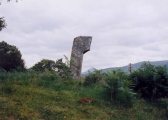
Neolithic and Bronze AgeSite Name: Oberhaverbeck DolmenCountry: Germany Land: Lower Saxony, Bremen Type: Burial Chamber or Dolmen
Nearest Town: Lueneburg Nearest Village: Haverbeck
Latitude: 53.148190N Longitude: 9.929077E
Condition:
| 5 | Perfect |
| 4 | Almost Perfect |
| 3 | Reasonable but with some damage |
| 2 | Ruined but still recognisable as an ancient site |
| 1 | Pretty much destroyed, possibly visible as crop marks |
| 0 | No data. |
| -1 | Completely destroyed |
| 5 | Superb |
| 4 | Good |
| 3 | Ordinary |
| 2 | Not Good |
| 1 | Awful |
| 0 | No data. |
| 5 | Can be driven to, probably with disabled access |
| 4 | Short walk on a footpath |
| 3 | Requiring a bit more of a walk |
| 2 | A long walk |
| 1 | In the middle of nowhere, a nightmare to find |
| 0 | No data. |
| 5 | co-ordinates taken by GPS or official recorded co-ordinates |
| 4 | co-ordinates scaled from a detailed map |
| 3 | co-ordinates scaled from a bad map |
| 2 | co-ordinates of the nearest village |
| 1 | co-ordinates of the nearest town |
| 0 | no data |
Internal Links:
External Links:
I have visited· I would like to visit
DrewParsons would like to visit
CharcoalBurner89 visited on 4th Jun 2021 - their rating: Cond: 4 Amb: 5 Access: 4 Easily reached by a short hike. A really beautiful place with the surrounding heather areas.
johnstone visited on 3rd Sep 2019 - their rating: Cond: 4 Amb: 5 Access: 4
Average ratings for this site from all visit loggers: Condition: 4 Ambience: 5 Access: 4
")
I'm sorry but I didn't find any information about this chamber.
I accidentaly discovered these stones in the natural preserve "Lüneburger Heide".
I think it's modern a dolmen.
Anyway, a nice location.
You may be viewing yesterday's version of this page. To see the most up to date information please register for a free account.
")
")
")
")
")
")
")
")
Do not use the above information on other web sites or publications without permission of the contributor.
Nearby sites
Click here to view sites on an interactive map of the areaDownload sites to:
KML (Google Earth)
GPX (GPS waypoints)
CSV (Garmin/Navman)
CSV (Excel)
To unlock full downloads you need to sign up as a Contributory Member. Otherwise downloads are limited to 50 sites.
Nearby sites listing. In the following links * = Image available
615m NE 54° Oberhaverbeck Grabhuegelgruppe* Round Barrow(s)
1.7km NNW 332° Niederhaverbeck Fuerstengrab* Round Barrow(s)
3.8km ENE 60° Hannibals Grab* Natural Stone / Erratic / Other Natural Feature
3.9km SE 141° Behringer Hügelgräberheide* Barrow Cemetery
4.2km NW 316° Trojaburg Schneverdingen* Turf Maze
7.9km E 92° Hügelgräber bei Hörpel* Round Barrow(s)
8.6km W 263° Summstein Schneverdingen Modern Stone Circle etc
8.9km ENE 66° Egestorf Grabhuegelgruppe* Round Barrow(s)
9.7km ENE 63° Egestorf Findling* Natural Stone / Erratic / Other Natural Feature
13.2km ENE 69° Luebberstedt Steingrab 1* Chambered Tomb
13.5km E 85° Rolfsen Steinkiste* Cist
13.6km ENE 67° Luebberstedt Steingrab 2* Burial Chamber or Dolmen
13.7km ENE 67° Luebberstedt Steingrab 3* Burial Chamber or Dolmen
15.1km ENE 74° Eyendorf Steingrab 1* Passage Grave
15.1km ENE 74° Eyendorf Steingrab 2* Chambered Tomb
15.1km ENE 74° Eyendorf Steingrab 3* Chambered Tomb
16.0km E 92° Soderstorf Steingrab* Passage Grave
16.0km ENE 76° Raven Steingrab 1* Chambered Tomb
16.0km E 92° Soderstorf Graeberfeld* Barrow Cemetery
16.2km ENE 78° Raven Jahrhundertstein* Natural Stone / Erratic / Other Natural Feature
16.3km E 90° Aspelhorn Huegelgrab 2* Round Barrow(s)
16.4km E 90° Aspelhorn Steingrab* Chambered Tomb
16.4km E 90° Aspelhorn Huegelgrab 1* Round Barrow(s)
17.4km E 80° Raven Steingrab 2* Passage Grave
17.5km E 80° Wetzen Steingrab* Passage Grave


 We would like to know more about this location. Please feel free to add a brief description and any relevant information in your own language.
 Wir möchten mehr über diese Stätte erfahren. Bitte zögern Sie nicht, eine kurze Beschreibung und relevante Informationen in Deutsch hinzuzufügen.
 Nous aimerions en savoir encore un peu sur les lieux. S'il vous plaît n'hesitez pas à ajouter une courte description et tous les renseignements pertinents dans votre propre langue.
 Quisieramos informarnos un poco más de las lugares. No dude en añadir una breve descripción y otros datos relevantes en su propio idioma.