

<< Text Pages >> St Leonard's Well (Pembrokeshire) - Holy Well or Sacred Spring in Wales in Pembrokeshire
Submitted by coldrum on Thursday, 07 January 2010 Page Views: 4744
Springs and Holy WellsSite Name: St Leonard's Well (Pembrokeshire)Country: Wales County: Pembrokeshire Type: Holy Well or Sacred Spring
Map Ref: SM98561890
Latitude: 51.832292N Longitude: 4.924987W
Condition:
| 5 | Perfect |
| 4 | Almost Perfect |
| 3 | Reasonable but with some damage |
| 2 | Ruined but still recognisable as an ancient site |
| 1 | Pretty much destroyed, possibly visible as crop marks |
| 0 | No data. |
| -1 | Completely destroyed |
| 5 | Superb |
| 4 | Good |
| 3 | Ordinary |
| 2 | Not Good |
| 1 | Awful |
| 0 | No data. |
| 5 | Can be driven to, probably with disabled access |
| 4 | Short walk on a footpath |
| 3 | Requiring a bit more of a walk |
| 2 | A long walk |
| 1 | In the middle of nowhere, a nightmare to find |
| 0 | No data. |
| 5 | co-ordinates taken by GPS or official recorded co-ordinates |
| 4 | co-ordinates scaled from a detailed map |
| 3 | co-ordinates scaled from a bad map |
| 2 | co-ordinates of the nearest village |
| 1 | co-ordinates of the nearest town |
| 0 | no data |
Be the first person to rate this site - see the 'Contribute!' box in the right hand menu.
Internal Links:
External Links:
Holy Well or Sacred Spring in Pembrokeshire (Sir Benfro)
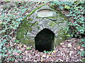
"A dry well-chamber, 1.3m high and 1.4m wide externally, set in the outer slope of the north-eastern rampart of Rudbaxton Rath."
From Coflein site no. 305249.
You may be viewing yesterday's version of this page. To see the most up to date information please register for a free account.
Do not use the above information on other web sites or publications without permission of the contributor.
Nearby Images from Geograph Britain and Ireland:
©2016(licence)
©2016(licence)
©2016(licence)
©2008(licence)
©2016(licence)
The above images may not be of the site on this page, they are loaded from Geograph.
Please Submit an Image of this site or go out and take one for us!
Click here to see more info for this site
Nearby sites
Key: Red: member's photo, Blue: 3rd party photo, Yellow: other image, Green: no photo - please go there and take one, Grey: site destroyed
Download sites to:
KML (Google Earth)
GPX (GPS waypoints)
CSV (Garmin/Navman)
CSV (Excel)
To unlock full downloads you need to sign up as a Contributory Member. Otherwise downloads are limited to 50 sites.
Turn off the page maps and other distractions
Nearby sites listing. In the following links * = Image available
45m SSW 204° Rudbaxton Rath Hillfort (SM98541886)
4.1km NNW 346° Spittal Church Early Christian Sculptured Stone (SM977229)
4.4km SSW 199° Uzmaston Barrow Round Barrow(s) (SM96981476)
4.5km SSW 210° Higgon's Well Holy Well or Sacred Spring (SM9618015071)
4.8km SW 218° Lady Well (Haverfordwest) Holy Well or Sacred Spring (SM9547615217)
5.7km SSW 208° Upper Haroldston Ancient Village or Settlement (SM95661395)
6.3km SW 221° St Caradoc's Well Holy Well or Sacred Spring (SM9423714271)
6.5km SW 222° St David's Well (Haverfordwest) Holy Well or Sacred Spring (SM94001423)
7.7km N 355° Parc Y Llyn* Burial Chamber or Dolmen (SM98232659)
8.3km NE 45° Parc-y-marl Misc. Earthwork (SN047245)
8.4km N 353° Garn Turne* Chambered Tomb (SM97922725)
9.0km NNE 21° Henne Barrow Round Barrow(s) (SN021272)
9.2km SSW 192° Trooper's Inn Round Barrow(s) (SM963100)
9.2km NW 312° Barnards Hill Tumulus Round Barrow(s) (SM91962536)
9.2km N 356° The Altar* Chambered Tomb (SM98282812)
9.2km NNW 347° Hogtivis Stone* Early Christian Sculptured Stone (SM969280)
9.4km NNW 337° Lower Broadmoor* Standing Stone (Menhir) (SM95212765)
9.7km ESE 119° Foel Eryr Hut Circle* Ancient Village or Settlement (SN069139)
9.9km WSW 242° Hangstone Davy Standing Stone (Menhir) (SM89581465)
10.0km SE 129° Cott Lane* Modern Stone Circle etc (SN0610312254)
10.1km WNW 302° Hayscastle Tump Round Barrow(s) (SM90232463)
10.3km NNW 326° St Lawrence Camp Promontory Fort / Cliff Castle (SM93212771)
10.3km NNE 32° Castell Hendre Ancient Village or Settlement (SN04472740)
10.5km WNW 299° Rhyndaston-Fawr* Standing Stone (Menhir) (SM89592433)
10.6km WNW 298° Rhyndaston-Fawr Tump Round Barrow(s) (SM89422425)
View more nearby sites and additional images


 We would like to know more about this location. Please feel free to add a brief description and any relevant information in your own language.
 Wir möchten mehr über diese Stätte erfahren. Bitte zögern Sie nicht, eine kurze Beschreibung und relevante Informationen in Deutsch hinzuzufügen.
 Nous aimerions en savoir encore un peu sur les lieux. S'il vous plaît n'hesitez pas à ajouter une courte description et tous les renseignements pertinents dans votre propre langue.
 Quisieramos informarnos un poco más de las lugares. No dude en añadir una breve descripción y otros datos relevantes en su propio idioma.