

<< Our Photo Pages >> Castle Haven - Stone Fort or Dun in Scotland in Dumfries and Galloway
Submitted by howe on Friday, 12 June 2009 Page Views: 10886
Multi-periodSite Name: Castle Haven Alternative Name: Castle Haven BayCountry: Scotland County: Dumfries and Galloway Type: Stone Fort or Dun
Nearest Town: Kircudbright Nearest Village: Kirkandrews
Map Ref: NX5934748270
Latitude: 54.809500N Longitude: 4.190066W
Condition:
| 5 | Perfect |
| 4 | Almost Perfect |
| 3 | Reasonable but with some damage |
| 2 | Ruined but still recognisable as an ancient site |
| 1 | Pretty much destroyed, possibly visible as crop marks |
| 0 | No data. |
| -1 | Completely destroyed |
| 5 | Superb |
| 4 | Good |
| 3 | Ordinary |
| 2 | Not Good |
| 1 | Awful |
| 0 | No data. |
| 5 | Can be driven to, probably with disabled access |
| 4 | Short walk on a footpath |
| 3 | Requiring a bit more of a walk |
| 2 | A long walk |
| 1 | In the middle of nowhere, a nightmare to find |
| 0 | No data. |
| 5 | co-ordinates taken by GPS or official recorded co-ordinates |
| 4 | co-ordinates scaled from a detailed map |
| 3 | co-ordinates scaled from a bad map |
| 2 | co-ordinates of the nearest village |
| 1 | co-ordinates of the nearest town |
| 0 | no data |
Internal Links:
External Links:
I have visited· I would like to visit
HaggisAction would like to visit
")
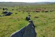
Castle Haven Dun. A D-shaped galleried dun with outer fortifications. Situated on a low raised cliff facing out into Wigtown Bay, it has a rear entry with a ruined stair leading down to the beach.
Described as an extraordinary structure in Canmore ID 63623, which says this " is as much a monument to the energetic enthusiasm of early 20th century antiquarians as to the needs and aspirations of an iron-age chieftain. It is Galloway's only known example of a galleried dun, a type of fortified homestead common in Argyll and the Western Isles. Castle Haven differs from its cousins of the western seaboard in a number of ways, and first impressions suggest that the height and condition of its drystone walls are one of its distinguishing features. However, its remarkable condition is the result of clearance and restoration work carried out in 1905 by its owner, the laird ofKnockbrex, partly with the aim of 'rendering it less liable to be trampled and destroyed than ifleft in the state in which it was . . .'. Before 1905 none of the walls was more than 1.2m in height, and the west wall, which runs along the rocky edge of Castle Haven Bay, was merely foundations."
You may be viewing yesterday's version of this page. To see the most up to date information please register for a free account.
")
")
")
")
")
Do not use the above information on other web sites or publications without permission of the contributor.
Click here to see more info for this site
Nearby sites
Key: Red: member's photo, Blue: 3rd party photo, Yellow: other image, Green: no photo - please go there and take one, Grey: site destroyed
Download sites to:
KML (Google Earth)
GPX (GPS waypoints)
CSV (Garmin/Navman)
CSV (Excel)
To unlock full downloads you need to sign up as a Contributory Member. Otherwise downloads are limited to 50 sites.
Turn off the page maps and other distractions
Nearby sites listing. In the following links * = Image available
921m ESE 103° St Andrew's Well (Borgue) Holy Well or Sacred Spring (NX6024148037)
984m E 83° Tongue Croft* Rock Art (NX60334836)
1.0km SE 144° Barn Heugh* Hillfort (NX59934741)
2.5km WNW 300° Ardwall Island Chapel & Burial Ground* Cairn (NX57254956)
5.0km E 101° Clauchandolly 1* Rock Art (NX64244714)
5.1km E 101° Clauchandolly 6 Rock Art (NX64384711)
5.2km E 100° Clauchandolly 8* Rock Art (NX64474722)
5.4km ESE 118° Brighouse* Standing Stone (Menhir) (NX64024555)
5.5km NW 306° Mossyard 6* Rock Art (NX5497951658)
5.7km WNW 301° Mossyard 1* Rock Art (NX54525141)
6.0km NW 307° Mossyard* Rock Art (NX54695204)
6.1km NW 313° Newton Cairn* Chambered Cairn (NX55065256)
7.2km NNW 334° Stone Triangle (Lagganmullan)* Modern Stone Circle etc (NX5641154896)
7.3km NNW 335° Lagganmullan 8* Rock Art (NX56475503)
7.3km NNW 335° Lagganmullan 9* Rock Art (NX56465504)
7.4km NW 312° High Auchenlarie* Stone Circle (NX53955342)
7.6km NNW 333° Lagganmullan 4* Rock Art (NX56095516)
7.7km NNW 334° Lagganmullan 3* Rock Art (NX56125528)
7.7km N 355° Anwoth* Class I Pictish Symbol Stone (NX58895601)
7.7km N 355° Trusty's Hill* Hillfort (NX58895601)
7.8km NNW 333° Mill Knock Standing Stones* Standing Stones (NX5597855343)
8.0km E 84° Monk's Well (Kirkcudbright) Holy Well or Sacred Spring (NX6730048892)
8.0km N 351° Rutherford's Well* Holy Well or Sacred Spring (NX58385622)
8.0km N 351° Rutherford's Well (Anwoth) Holy Well or Sacred Spring (NX5838856224)
8.1km NNW 349° St John's Well (Anwoth) Holy Well or Sacred Spring (NX5800456296)
View more nearby sites and additional images


 We would like to know more about this location. Please feel free to add a brief description and any relevant information in your own language.
 Wir möchten mehr über diese Stätte erfahren. Bitte zögern Sie nicht, eine kurze Beschreibung und relevante Informationen in Deutsch hinzuzufügen.
 Nous aimerions en savoir encore un peu sur les lieux. S'il vous plaît n'hesitez pas à ajouter une courte description et tous les renseignements pertinents dans votre propre langue.
 Quisieramos informarnos un poco más de las lugares. No dude en añadir una breve descripción y otros datos relevantes en su propio idioma.