

<< Our Photo Pages >> Rehbergholz Langbett 1 - Long Barrow in Germany in Schleswig-Holstein, Hamburg
Submitted by holger_rix on Saturday, 06 September 2008 Page Views: 3294
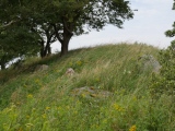
Neolithic and Bronze AgeSite Name: Rehbergholz Langbett 1 Alternative Name: Sprockhoff 40, Pinnesgrab, Pinnisgrab, Pen-GrabCountry: Germany Land: Schleswig-Holstein, Hamburg Type: Long Barrow
Nearest Town: Schleswig Nearest Village: Satrup
Latitude: 54.664333N Longitude: 9.623253E
Condition:
| 5 | Perfect |
| 4 | Almost Perfect |
| 3 | Reasonable but with some damage |
| 2 | Ruined but still recognisable as an ancient site |
| 1 | Pretty much destroyed, possibly visible as crop marks |
| 0 | No data. |
| -1 | Completely destroyed |
| 5 | Superb |
| 4 | Good |
| 3 | Ordinary |
| 2 | Not Good |
| 1 | Awful |
| 0 | No data. |
| 5 | Can be driven to, probably with disabled access |
| 4 | Short walk on a footpath |
| 3 | Requiring a bit more of a walk |
| 2 | A long walk |
| 1 | In the middle of nowhere, a nightmare to find |
| 0 | No data. |
| 5 | co-ordinates taken by GPS or official recorded co-ordinates |
| 4 | co-ordinates scaled from a detailed map |
| 3 | co-ordinates scaled from a bad map |
| 2 | co-ordinates of the nearest village |
| 1 | co-ordinates of the nearest town |
| 0 | no data |
Internal Links:
External Links:
")
The long barrow is well known as 'Pinnesgrab'. Old stories tell that a robbers captain called Pinnes or Pinas has been buried here.
Up until the year 1900 the people from the near villages gathered here once a year to sing and dance.
You may be viewing yesterday's version of this page. To see the most up to date information please register for a free account.
")
")
")
")
")
Do not use the above information on other web sites or publications without permission of the contributor.
Click here to see more info for this site
Nearby sites
Click here to view sites on an interactive map of the areaKey: Red: member's photo, Blue: 3rd party photo, Yellow: other image, Green: no photo - please go there and take one, Grey: site destroyed
Download sites to:
KML (Google Earth)
GPX (GPS waypoints)
CSV (Garmin/Navman)
CSV (Excel)
To unlock full downloads you need to sign up as a Contributory Member. Otherwise downloads are limited to 50 sites.
Turn off the page maps and other distractions
Nearby sites listing. In the following links * = Image available
454m NNW 327° Rehbergholz Langbett 2* Long Barrow
824m WSW 243° Rehbergholz Langbett 3* Long Barrow
6.4km W 272° Hostrup Grabhuegel* Round Barrow(s)
9.3km S 188° Brekling Steingrab* Burial Chamber or Dolmen
9.6km WNW 282° Gross Soltfeld Huenenbett* Long Barrow
9.6km WSW 250° Stenderup Huegelgrab 1* Round Barrow(s)
9.6km ESE 105° Suederbrarup Grabhuegel Kummerhy* Standing Stones
9.7km WSW 250° Stenderup Huegelgrab 2* Round Barrow(s)
9.8km ESE 105° Thorsberger Moor (Suederbrarup)* Ancient Village or Settlement
10.3km SSW 208° Suederfahrenstedt Grabhuegel Round Barrow(s)
10.6km ESE 104° Heilige Quelle Süderbrarup* Holy Well or Sacred Spring
10.7km NW 309° Kleinwolstrup Steingrab 2 Chambered Tomb
10.8km NW 309° Kleinwolstrup Steingrab 1 Chambered Tomb
11.2km WSW 237° Poppostein Steinkammergrab* Burial Chamber or Dolmen
11.6km W 267° Suederschmedeby Steingrab* Burial Chamber or Dolmen
11.7km E 80° Brarupholz* Barrow Cemetery
11.9km SW 223° Idstedt Huegelgrab 2* Round Barrow(s)
12.1km SW 223° Idstedt Huegelgrab 3* Round Barrow(s)
12.2km SSE 168° Schaalby Grabhuegel 1* Round Barrow(s)
12.2km SSE 168° Schaalby Grabhuegel 2* Round Barrow(s)
12.6km NNW 340° Husby Grabhuegel* Round Barrow(s)
12.6km SW 221° Idstedt Huegelgrab 1* Round Barrow(s)
12.7km WNW 298° Munkwolstrup Langbett 3* Long Barrow
12.7km NNW 337° Weseby Steingrab* Burial Chamber or Dolmen
12.7km WNW 298° Munkwolstrup Langbett 2* Long Barrow
View more nearby sites and additional images


 We would like to know more about this location. Please feel free to add a brief description and any relevant information in your own language.
 Wir möchten mehr über diese Stätte erfahren. Bitte zögern Sie nicht, eine kurze Beschreibung und relevante Informationen in Deutsch hinzuzufügen.
 Nous aimerions en savoir encore un peu sur les lieux. S'il vous plaît n'hesitez pas à ajouter une courte description et tous les renseignements pertinents dans votre propre langue.
 Quisieramos informarnos un poco más de las lugares. No dude en añadir una breve descripción y otros datos relevantes en su propio idioma.