

<< Our Photo Pages >> Røddinge Klekkende Høj Jættestue - Passage Grave in Denmark in Møn + Lolland-Falster
Submitted by Martin_L on Wednesday, 07 January 2009 Page Views: 11059
Neolithic and Bronze AgeSite Name: Røddinge Klekkende Høj Jættestue Alternative Name: Klekkende-Høj, KlekkendehojCountry: Denmark County: Møn + Lolland-Falster Type: Passage Grave
Nearest Town: Stege Nearest Village: Klekkende
Latitude: 54.936260N Longitude: 12.164120E
Condition:
| 5 | Perfect |
| 4 | Almost Perfect |
| 3 | Reasonable but with some damage |
| 2 | Ruined but still recognisable as an ancient site |
| 1 | Pretty much destroyed, possibly visible as crop marks |
| 0 | No data. |
| -1 | Completely destroyed |
| 5 | Superb |
| 4 | Good |
| 3 | Ordinary |
| 2 | Not Good |
| 1 | Awful |
| 0 | No data. |
| 5 | Can be driven to, probably with disabled access |
| 4 | Short walk on a footpath |
| 3 | Requiring a bit more of a walk |
| 2 | A long walk |
| 1 | In the middle of nowhere, a nightmare to find |
| 0 | No data. |
| 5 | co-ordinates taken by GPS or official recorded co-ordinates |
| 4 | co-ordinates scaled from a detailed map |
| 3 | co-ordinates scaled from a bad map |
| 2 | co-ordinates of the nearest village |
| 1 | co-ordinates of the nearest town |
| 0 | no data |
Internal Links:
External Links:
I have visited· I would like to visit
PeterR87 rrmoser would like to visit
Boeddel visited on 12th Aug 2018 - their rating: Access: 4 beautiful
combuijs visited on 10th Jul 2015 - their rating: Cond: 5 Amb: 5 Access: 4 Well signposted, ample parking space. Remarkable double passage grave, you can only enter one though. Another surprising feature is a terrace surrounding the mound.
XIII visited on 1st Aug 2013 - their rating: Cond: 4 Amb: 5 Access: 4
43559959 visited on 13th Jul 2010 - their rating: Cond: 4 Amb: 4 Access: 4
NeolithicFanatic ShamrockStone DrewParsons Martin_L maddy have visited here
Average ratings for this site from all visit loggers: Condition: 4.33 Ambience: 4.67 Access: 4
")
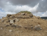
Nowadays it is possible to have a view from one chamber-part to the other through a small gap. The two chamber parts are of similar size: 4,34m x 2,1m (southern part) and 4,7m x 1,8m (northern-part). The chambers are comparativly low with a maximum height of 1,25m. The passages are facing approximately northeast. Both have two bottlenecks, where they are narrowed by protruding orthostats. Obviously it was so important to the neolithic people to have two separated chamber-parts, that they even accepted the enormous extra-effort to build two passages.
Reference: Kulturarvsstyrelsen, København
Klekkende Høj, Røddinge (Klekkende Höj, Röddinge)
Damsholte sogn SB 85, Mønbo herred, Præstø amt
Note:
You may be viewing yesterday's version of this page. To see the most up to date information please register for a free account.
")
")
")
")
")
")
")
")
")
")
")
")
")
")
")
")
")
")
")
")
")
")
")
")
These are just the first 25 photos of Røddinge Klekkende Høj Jættestue. If you log in with a free user account you will be able to see our entire collection.
Do not use the above information on other web sites or publications without permission of the contributor.
Click here to see more info for this site
Nearby sites
Click here to view sites on an interactive map of the areaKey: Red: member's photo, Blue: 3rd party photo, Yellow: other image, Green: no photo - please go there and take one, Grey: site destroyed
Download sites to:
KML (Google Earth)
GPX (GPS waypoints)
CSV (Garmin/Navman)
CSV (Excel)
To unlock full downloads you need to sign up as a Contributory Member. Otherwise downloads are limited to 50 sites.
Turn off the page maps and other distractions
Nearby sites listing. In the following links * = Image available
1.3km NNE 31° Røddinge Runddysse* Burial Chamber or Dolmen
2.2km NNW 328° Sprove Langdysse* Long Barrow
2.6km ENE 71° Marienborg Kløvervænget Langdysse * Long Barrow
2.6km NW 325° Sprove Jættestue* Passage Grave
2.8km NNW 327° Sprove Kong Asgers Høj* Passage Grave
2.8km SSW 209° Store Damme Barhøj Runddysse* Burial Chamber or Dolmen
2.9km ESE 115° Marienborg Nylukke Skov Langdysse 2* Long Barrow
2.9km SSE 164° Vollerup Langdysse 1* Long Barrow
2.9km ESE 116° Marienborg Nylukke Skov Langdysse 1* Long Barrow
3.1km ESE 119° Marienborg Nylukke Skov Rundhøj* Round Barrow(s)
3.9km E 91° Vængemarken Rundhøj* Round Barrow(s)
3.9km S 185° Vollerup Langdysse 2* Long Barrow
4.0km SSE 168° Haarbølle Rundhøj* Round Barrow(s)
4.5km S 190° Grønsalen Grønjægers Høj* Long Barrow
4.9km SE 145° Fanefjord Skov Rundhøj 2* Round Barrow(s)
4.9km SE 145° Fanefjord Skov Rundhøj 1* Round Barrow(s)
5.1km ENE 75° Æbelnæs Jættestue* Passage Grave
5.2km WSW 256° Bogø Østerskov Langdysse 4* Long Barrow
5.2km WSW 256° Bogø Østerskov Langdysse 5* Long Barrow
5.2km SSE 149° Mortenshøj (Fanefjord Skov)* Round Barrow(s)
5.2km SSE 160° Maalehøj* Round Barrow(s)
5.4km W 261° Bogø Østerskov Runddysse* Burial Chamber or Dolmen
5.5km W 262° Bogø Østerskov Langdysse 3* Long Barrow
5.5km W 262° Bogø Østerskov Langdysse 1* Long Barrow
5.6km WSW 250° Bogø Langdysse 3* Long Barrow
View more nearby sites and additional images


 We would like to know more about this location. Please feel free to add a brief description and any relevant information in your own language.
 Wir möchten mehr über diese Stätte erfahren. Bitte zögern Sie nicht, eine kurze Beschreibung und relevante Informationen in Deutsch hinzuzufügen.
 Nous aimerions en savoir encore un peu sur les lieux. S'il vous plaît n'hesitez pas à ajouter une courte description et tous les renseignements pertinents dans votre propre langue.
 Quisieramos informarnos un poco más de las lugares. No dude en añadir una breve descripción y otros datos relevantes en su propio idioma.