

<< Our Photo Pages >> Ceresa Menhir 1 - Standing Stone (Menhir) in Italy in Liguria
Submitted by AlexHunger on Wednesday, 06 August 2008 Page Views: 5172
Neolithic and Bronze AgeSite Name: Ceresa Menhir 1 Alternative Name: Dolmen of the water snakeCountry: Italy Region: Liguria Type: Standing Stone (Menhir)
Nearest Town: Genova Nearest Village: Alpicella
Latitude: 44.407050N Longitude: 8.550280E
Condition:
| 5 | Perfect |
| 4 | Almost Perfect |
| 3 | Reasonable but with some damage |
| 2 | Ruined but still recognisable as an ancient site |
| 1 | Pretty much destroyed, possibly visible as crop marks |
| 0 | No data. |
| -1 | Completely destroyed |
| 5 | Superb |
| 4 | Good |
| 3 | Ordinary |
| 2 | Not Good |
| 1 | Awful |
| 0 | No data. |
| 5 | Can be driven to, probably with disabled access |
| 4 | Short walk on a footpath |
| 3 | Requiring a bit more of a walk |
| 2 | A long walk |
| 1 | In the middle of nowhere, a nightmare to find |
| 0 | No data. |
| 5 | co-ordinates taken by GPS or official recorded co-ordinates |
| 4 | co-ordinates scaled from a detailed map |
| 3 | co-ordinates scaled from a bad map |
| 2 | co-ordinates of the nearest village |
| 1 | co-ordinates of the nearest town |
| 0 | no data |
Internal Links:
External Links:
")
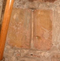
Medium sized triangular menhir on side of Hill, just below Ceresa Menhir 2 near the Monte Beigua. Believed to be part of a sanctuary consisting of several nearby celtic Ligurian sites including Della Biscia Dolmen and the Monte Beigua Strada Megalitica. Comment by McGlen On the left side of the menhir, there are two rectangular engraves, the lower engrave is smaller than the other one. The biggest engrave are about 10 cm length and 5cm large
You may be viewing yesterday's version of this page. To see the most up to date information please register for a free account.
")
")
Do not use the above information on other web sites or publications without permission of the contributor.
Nearby Images from Flickr


The above images may not be of the site on this page, but were taken nearby. They are loaded from Flickr so please click on them for image credits.
Click here to see more info for this site
Nearby sites
Click here to view sites on an interactive map of the areaKey: Red: member's photo, Blue: 3rd party photo, Yellow: other image, Green: no photo - please go there and take one, Grey: site destroyed
Download sites to:
KML (Google Earth)
GPX (GPS waypoints)
CSV (Garmin/Navman)
CSV (Excel)
To unlock full downloads you need to sign up as a Contributory Member. Otherwise downloads are limited to 50 sites.
Turn off the page maps and other distractions
Nearby sites listing. In the following links * = Image available
81m ESE 120° Ceresa Cup Mark Stone Rock Art
83m NE 40° Ceresa Menhir 2* Standing Stone (Menhir)
171m W 260° Ceresa Marked Stone* Rock Art
171m W 260° Ceresa Engraved Stone* Rock Art
367m ENE 61° Ceresa Rock Altar* Natural Stone / Erratic / Other Natural Feature
733m ESE 109° Monte Beigua Strada Megalitica* Ancient Trackway
793m ESE 111° South Beigua Menhir* Standing Stone (Menhir)
883m NE 55° Faie Cup Mark Stone Rock Art
1.3km W 262° U Nicciu du Briccu du Broxin Christianised Menhir Early Christian Sculptured Stone
3.5km NW 309° Bric Aliberti Engraved stone Rock Art
4.5km NE 35° Della Biscia Dolmen Burial Chamber or Dolmen
4.6km NE 38° Della Biscia Pria Scugia Engraved stone Rock Art
6.0km SE 138° Cian da Munega Menhir* Standing Stone (Menhir)
11.1km ENE 57° Faiallo's Stone* Standing Stone (Menhir)
11.6km ENE 57° Faiallo's standing stone (2)* Standing Stone (Menhir)
19.2km ENE 64° Issel's Cup Mark Stone Rock Art
19.3km ENE 64° Giutte Cairn Cairn
26.4km SW 224° Riparo di Rocca Due Teste* Ancient Village or Settlement
26.7km SSW 212° Pian del Ciliegio Rock Shelter* Cave or Rock Shelter
26.9km SW 216° Megalithic structure above Arma Strapatente* Cave or Rock Shelter
29.0km SW 218° Bric Le Pile* Rock Art
29.1km SW 219° Menhir close stone table near Bric Le Pile* Standing Stone (Menhir)
29.1km SW 219° Altar Stone near Bric Le Pile* Rock Art
29.1km SW 219° Anthropomorphic stele near Bric Le Pile* Standing Stone (Menhir)
29.5km SW 216° Bric Ercea* Rock Art
View more nearby sites and additional images


 We would like to know more about this location. Please feel free to add a brief description and any relevant information in your own language.
 Wir möchten mehr über diese Stätte erfahren. Bitte zögern Sie nicht, eine kurze Beschreibung und relevante Informationen in Deutsch hinzuzufügen.
 Nous aimerions en savoir encore un peu sur les lieux. S'il vous plaît n'hesitez pas à ajouter une courte description et tous les renseignements pertinents dans votre propre langue.
 Quisieramos informarnos un poco más de las lugares. No dude en añadir una breve descripción y otros datos relevantes en su propio idioma.