<< Our Photo Pages >> Barras Nose Cave - Cave or Rock Shelter in England in Cornwall
Submitted by coldrum on Saturday, 26 July 2008 Page Views: 7344
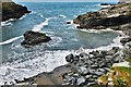
Natural PlacesSite Name: Barras Nose CaveCountry: England County: Cornwall Type: Cave or Rock Shelter
Nearest Village: Tintagel
Map Ref: SX052891
Latitude: 50.668894N Longitude: 4.758049W
Condition:
| 5 | Perfect |
| 4 | Almost Perfect |
| 3 | Reasonable but with some damage |
| 2 | Ruined but still recognisable as an ancient site |
| 1 | Pretty much destroyed, possibly visible as crop marks |
| 0 | No data. |
| -1 | Completely destroyed |
| 5 | Superb |
| 4 | Good |
| 3 | Ordinary |
| 2 | Not Good |
| 1 | Awful |
| 0 | No data. |
| 5 | Can be driven to, probably with disabled access |
| 4 | Short walk on a footpath |
| 3 | Requiring a bit more of a walk |
| 2 | A long walk |
| 1 | In the middle of nowhere, a nightmare to find |
| 0 | No data. |
| 5 | co-ordinates taken by GPS or official recorded co-ordinates |
| 4 | co-ordinates scaled from a detailed map |
| 3 | co-ordinates scaled from a bad map |
| 2 | co-ordinates of the nearest village |
| 1 | co-ordinates of the nearest town |
| 0 | no data |
Be the first person to rate this site - see the 'Contribute!' box in the right hand menu.
Internal Links:
External Links:
I have visited· I would like to visit
hevveh saw from a distance
Ogham have visited here
")
Cave.
You may be viewing yesterday's version of this page. To see the most up to date information please register for a free account.
")
")
Do not use the above information on other web sites or publications without permission of the contributor.
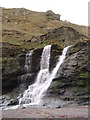
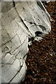
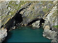
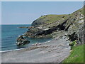
Nearby Images from Geograph Britain and Ireland:
©2008(licence)
©2008(licence)
©2023(licence)
©2021(licence)
©2018(licence)
The above images may not be of the site on this page, they are loaded from Geograph.
Please Submit an Image of this site or go out and take one for us!
Click here to see more info for this site
Nearby sites
Key: Red: member's photo, Blue: 3rd party photo, Yellow: other image, Green: no photo - please go there and take one, Grey: site destroyed
Download sites to:
KML (Google Earth)
GPX (GPS waypoints)
CSV (Garmin/Navman)
CSV (Excel)
To unlock full downloads you need to sign up as a Contributory Member. Otherwise downloads are limited to 50 sites.
Turn off the page maps and other distractions
Nearby sites listing. In the following links * = Image available
114m SW 230° Merlin's Cave (Cornwall)* Cave or Rock Shelter (SX05118903)
217m W 274° Tintagel Cliff Castle* Promontory Fort / Cliff Castle (SX0498489124)
411m WNW 282° Tintagel Head Holy Well or Sacred Spring (SX048892)
593m S 172° Standing stone near Wootons Inn* Marker Stone (SX05268851)
618m SSW 192° St. Materiana standing stone* Standing Stone (Menhir) (SX05058850)
671m SSW 192° St Materiana's Church (Tintagel)* Ancient Cross (SX05038845)
700m S 178° Tintagel Earthwork Misc. Earthwork (SX052884)
886m SE 139° Aelnet's Cross (Tintagel)* Ancient Cross (SX0575888410)
894m SSW 204° Glebe Cliff Cave Cave or Rock Shelter (SX048883)
942m SE 146° Merlins Cave Modern Stone Circle* Modern Stone Circle etc (SX057883)
1.1km ENE 61° Bossiney Settlement* Ancient Village or Settlement (SX062896)
1.1km S 188° Glebe Cliff Tumulus* Round Barrow(s) (SX050880)
1.5km ESE 104° Bossiney Mound* Artificial Mound (SX066887)
1.6km SSW 193° Dennis Scale Caves Cave or Rock Shelter (SX048876)
1.6km SW 225° Tintagel Cup Marks Rock Shelter Rock Art (SX0488)
1.8km S 181° Hole Beach Caves Cave or Rock Shelter (SX051873)
2.1km E 82° Rocky Valley* Carving (SX073893)
2.1km ESE 110° Fenterleigh* Ancient Cross (SX07178832)
2.4km E 88° Trethevey Roman Stone* Sculptured Stone (SX076891)
2.5km E 86° St Peran's Well* Holy Well or Sacred Spring (SX07668920)
2.6km E 79° King Arthur's Quoit* Chambered Tomb (SX07808951)
2.9km E 100° St Nectan's Glen* Holy Well or Sacred Spring (SX080885)
3.0km NE 56° Ladies' Window* Natural Stone / Erratic / Other Natural Feature (SX07749069)
3.0km ENE 71° Trevalga Cross* Ancient Cross (SX081900)
3.6km S 189° Start Point Tumuli Barrow Cemetery (SX045856)
View more nearby sites and additional images


 We would like to know more about this location. Please feel free to add a brief description and any relevant information in your own language.
 Wir möchten mehr über diese Stätte erfahren. Bitte zögern Sie nicht, eine kurze Beschreibung und relevante Informationen in Deutsch hinzuzufügen.
 Nous aimerions en savoir encore un peu sur les lieux. S'il vous plaît n'hesitez pas à ajouter une courte description et tous les renseignements pertinents dans votre propre langue.
 Quisieramos informarnos un poco más de las lugares. No dude en añadir una breve descripción y otros datos relevantes en su propio idioma.