

<< Text Pages >> žába - Natural Stone / Erratic / Other Natural Feature in Czech Republic
Submitted by AlexHunger on Wednesday, 17 May 2006 Page Views: 2500
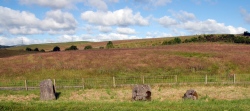
Natural PlacesSite Name: žábaCountry: Czech Republic Type: Natural Stone / Erratic / Other Natural Feature
Nearest Town: Praha Nearest Village: Drnek
Latitude: 50.197780N Longitude: 13.994440E
Condition:
| 5 | Perfect |
| 4 | Almost Perfect |
| 3 | Reasonable but with some damage |
| 2 | Ruined but still recognisable as an ancient site |
| 1 | Pretty much destroyed, possibly visible as crop marks |
| 0 | No data. |
| -1 | Completely destroyed |
| 5 | Superb |
| 4 | Good |
| 3 | Ordinary |
| 2 | Not Good |
| 1 | Awful |
| 0 | No data. |
| 5 | Can be driven to, probably with disabled access |
| 4 | Short walk on a footpath |
| 3 | Requiring a bit more of a walk |
| 2 | A long walk |
| 1 | In the middle of nowhere, a nightmare to find |
| 0 | No data. |
| 5 | co-ordinates taken by GPS or official recorded co-ordinates |
| 4 | co-ordinates scaled from a detailed map |
| 3 | co-ordinates scaled from a bad map |
| 2 | co-ordinates of the nearest village |
| 1 | co-ordinates of the nearest town |
| 0 | no data |
Be the first person to rate this site - see the 'Contribute!' box in the right hand menu.
Internal Links:
External Links:
Natural Stone / Glacial Erratic in the Czech Republic, Bohemia.
You may be viewing yesterday's version of this page. To see the most up to date information please register for a free account.
")
")
")
")
")
")
")
")
")
")
")
")
")
")
")
")
")
")
")
")
")
")
")
")
")
These are just the first 25 photos of žába. If you log in with a free user account you will be able to see our entire collection.
Do not use the above information on other web sites or publications without permission of the contributor.
Click here to see more info for this site
Nearby sites
Click here to view sites on an interactive map of the areaKey: Red: member's photo, Blue: 3rd party photo, Yellow: other image, Green: no photo - please go there and take one, Grey: site destroyed
Download sites to:
KML (Google Earth)
GPX (GPS waypoints)
CSV (Garmin/Navman)
CSV (Excel)
To unlock full downloads you need to sign up as a Contributory Member. Otherwise downloads are limited to 50 sites.
Turn off the page maps and other distractions
Nearby sites listing. In the following links * = Image available
2.3km WNW 285° Drnek Stone Circle* Stone Circle
2.5km SSE 157° Smečno Menhir* Standing Stone (Menhir)
2.9km ENE 60° Ledce Stones* Standing Stones
6.1km WSW 239° Mšecké Žehrovice Viereckschanze* Hillfort
6.6km S 182° Tuchlovice Cross Stone* Ancient Cross
6.7km S 183° Tuchlovice Menhir* Standing Stone (Menhir)
7.2km ESE 109° Vinařice Menhir* Standing Stone (Menhir)
8.0km ENE 62° Slánská Mountain Menhir 2* Standing Stone (Menhir)
8.0km ENE 63° Slánská Mountain Menhir 1* Standing Stone (Menhir)
8.1km SSE 167° Saint Roch Stone* Rock Outcrop
8.9km E 80° Jemníky Menhir* Standing Stone (Menhir)
10.4km SSE 149° Barrow Cemetery Hora (The Hill)* Barrow Cemetery
11.0km SSE 160° Družec Menhir* Standing Stone (Menhir)
11.2km SSE 148° Velká Dobrá Stone* Standing Stone (Menhir)
11.5km N 356° U Zkamenelého Pastýre* Standing Stone (Menhir)
12.3km S 174° Lhota Stone* Standing Stone (Menhir)
12.6km S 182° Spanilá hůrka (Graceful height)* Round Barrow(s)
14.7km S 176° Bratronice Menhir* Standing Stone (Menhir)
14.8km WSW 256° Louštín* Hillfort
14.9km ENE 71° Kamenný Most Menhir* Standing Stone (Menhir)
15.7km SSE 166° Žlábek holy well (Hollow)* Holy Well or Sacred Spring
15.8km S 180° Belec* Standing Stone (Menhir)
16.1km NNW 340° Hrivcice Menhir* Standing Stone (Menhir)
16.2km SSE 162° High Hill hillfort* Hillfort
16.3km N 351° Bozenina studánka* Holy Well or Sacred Spring
View more nearby sites and additional images


 We would like to know more about this location. Please feel free to add a brief description and any relevant information in your own language.
 Wir möchten mehr über diese Stätte erfahren. Bitte zögern Sie nicht, eine kurze Beschreibung und relevante Informationen in Deutsch hinzuzufügen.
 Nous aimerions en savoir encore un peu sur les lieux. S'il vous plaît n'hesitez pas à ajouter une courte description et tous les renseignements pertinents dans votre propre langue.
 Quisieramos informarnos un poco más de las lugares. No dude en añadir una breve descripción y otros datos relevantes en su propio idioma.