

<< Our Photo Pages >> Angel Mounds - Ancient Village or Settlement in United States in Great Lakes Midwest
Submitted by bat400 on Tuesday, 23 March 2021 Page Views: 19156
Multi-periodSite Name: Angel MoundsCountry: United States Region: Great Lakes Midwest Type: Ancient Village or Settlement
Nearest Town: Evansville, Indiana Nearest Village: Newburgh, Indiana
Latitude: 37.944000N Longitude: 87.454W
Condition:
| 5 | Perfect |
| 4 | Almost Perfect |
| 3 | Reasonable but with some damage |
| 2 | Ruined but still recognisable as an ancient site |
| 1 | Pretty much destroyed, possibly visible as crop marks |
| 0 | No data. |
| -1 | Completely destroyed |
| 5 | Superb |
| 4 | Good |
| 3 | Ordinary |
| 2 | Not Good |
| 1 | Awful |
| 0 | No data. |
| 5 | Can be driven to, probably with disabled access |
| 4 | Short walk on a footpath |
| 3 | Requiring a bit more of a walk |
| 2 | A long walk |
| 1 | In the middle of nowhere, a nightmare to find |
| 0 | No data. |
| 5 | co-ordinates taken by GPS or official recorded co-ordinates |
| 4 | co-ordinates scaled from a detailed map |
| 3 | co-ordinates scaled from a bad map |
| 2 | co-ordinates of the nearest village |
| 1 | co-ordinates of the nearest town |
| 0 | no data |
Internal Links:
External Links:
I have visited· I would like to visit
rrmoser would like to visit
bat400 has visited here
")
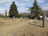
The only visible remains are the mounds themselves and some indications of earthworks. The site (a farm until 1938) has been kept cleared of most trees to better view the mounds and represent the layout as a Mississipian village. The Visitors Center run by the State of Indiana includes a museum with artifacts and some reconstructions of houses, stockade walls, and other buildings, based on archeological findings of Indiana University excavations. Several of the mounds have never been excavated.
Official Website here or there's an archive of their old site here.
DNA testing settles 70-year mystery over possible conjoined twins buried at ancient Angel Mounds site. This and more in the comments below.
Note: Again highlighting our epic Music Inspired by Prehistoric Sites thread here's the completely 'out there' Four Assignments by Max Syedtollan featuring Angel Mounds, Indiana.
You may be viewing yesterday's version of this page. To see the most up to date information please register for a free account.
")
")
")
")
")
")
")
")
")
")
")
")
")
")
")
")
")
")
")
")
")
")
")
")
These are just the first 25 photos of Angel Mounds. If you log in with a free user account you will be able to see our entire collection.
Do not use the above information on other web sites or publications without permission of the contributor.
Click here to see more info for this site
Nearby sites
Click here to view sites on an interactive map of the areaKey: Red: member's photo, Blue: 3rd party photo, Yellow: other image, Green: no photo - please go there and take one, Grey: site destroyed
Download sites to:
KML (Google Earth)
GPX (GPS waypoints)
CSV (Garmin/Navman)
CSV (Excel)
To unlock full downloads you need to sign up as a Contributory Member. Otherwise downloads are limited to 50 sites.
Turn off the page maps and other distractions
Nearby sites listing. In the following links * = Image available
239m SSW 202° Angel Mounds - Mound A* Artificial Mound
263m E 92° Angel Mounds Museum* Museum
312m W 260° Angel Mounds - Mound E* Artificial Mound
637m NE 46° Angel Mounds - Mound G* Artificial Mound
656m SW 227° Angel Mounds - Mound F* Pyramid / Mastaba
34.0km W 264° Mann Site Misc. Earthwork
42.5km W 263° GE. Mound Artificial Mound
44.3km WSW 252° Hovey Lake Village Ancient Village or Settlement
51.0km W 277° Wilson Mounds and Village Site* Artificial Mound
52.5km WSW 249° Slack Farm Ancient Village or Settlement
77.1km NNE 31° Glendale Ridge Archaeological Site Ancient Village or Settlement
78.4km WSW 250° Great Salt Spring Ancient Mine, Quarry or other Industry
79.2km N 356° Pyramid Mound* Barrow Cemetery
80.9km N 357° Indiana - Sugarloaf Mound* Barrow Cemetery
87.2km SSE 151° Indian Knoll* Barrow Cemetery
106.2km ENE 72° Wyandotte Cave* Ancient Mine, Quarry or other Industry
110.2km NE 52° Cox's Woods site Ancient Village or Settlement
118.0km SSE 156° Page Site, Kentucky* Artificial Mound
124.0km N 355° Merom Hillfort Ancient Village or Settlement
132.7km SW 224° Kincaid Mounds* Ancient Village or Settlement
140.6km SW 228° Rowlandton Mound Site* Artificial Mound
145.5km SE 125° Mammoth Cave Kentucky* Cave or Rock Shelter
157.3km WSW 257° Giant City Stone Fort Site* Hillfort
158.4km NNE 30° Glenn Black Laboratory* Museum
169.5km ENE 71° Moundbuilder's Fort Not Known (by us)
View more nearby sites and additional images


 We would like to know more about this location. Please feel free to add a brief description and any relevant information in your own language.
 Wir möchten mehr über diese Stätte erfahren. Bitte zögern Sie nicht, eine kurze Beschreibung und relevante Informationen in Deutsch hinzuzufügen.
 Nous aimerions en savoir encore un peu sur les lieux. S'il vous plaît n'hesitez pas à ajouter une courte description et tous les renseignements pertinents dans votre propre langue.
 Quisieramos informarnos un poco más de las lugares. No dude en añadir una breve descripción y otros datos relevantes en su propio idioma.