 with our Megalithic Portal iPhone app")

<< Our Photo Pages >> King's Quoit, Manorbier - Burial Chamber or Dolmen in Wales in Pembrokeshire
Submitted by sem on Saturday, 11 June 2022 Page Views: 31381
Neolithic and Bronze AgeSite Name: King's Quoit, ManorbierCountry: Wales County: Pembrokeshire Type: Burial Chamber or Dolmen
Nearest Town: Tenby Nearest Village: Manorbier
Map Ref: SS05939728 Landranger Map Number: 158
Latitude: 51.640749N Longitude: 4.806103W
Condition:
| 5 | Perfect |
| 4 | Almost Perfect |
| 3 | Reasonable but with some damage |
| 2 | Ruined but still recognisable as an ancient site |
| 1 | Pretty much destroyed, possibly visible as crop marks |
| 0 | No data. |
| -1 | Completely destroyed |
| 5 | Superb |
| 4 | Good |
| 3 | Ordinary |
| 2 | Not Good |
| 1 | Awful |
| 0 | No data. |
| 5 | Can be driven to, probably with disabled access |
| 4 | Short walk on a footpath |
| 3 | Requiring a bit more of a walk |
| 2 | A long walk |
| 1 | In the middle of nowhere, a nightmare to find |
| 0 | No data. |
| 5 | co-ordinates taken by GPS or official recorded co-ordinates |
| 4 | co-ordinates scaled from a detailed map |
| 3 | co-ordinates scaled from a bad map |
| 2 | co-ordinates of the nearest village |
| 1 | co-ordinates of the nearest town |
| 0 | no data |
Internal Links:
External Links:
I have visited· I would like to visit
Jimwithnoname rrmoser would like to visit
woodini254 visited on 12th Jun 2012 - their rating: Cond: 4 Amb: 4 Access: 4 Directions
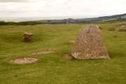
The Kings Quoit is located south west on a small bank above a cliff face immediately adjacent to the Pembrokeshire coastal foot path approximately 300m from the beach at Manorbeir Bay
Description
The monument which faces inland towards Manorbeir consists of a huge single capstone of local stone supported by two uprights, although a third upright located at the south eastern end, which is now probably collapsed. The position of the three uprights suggests that the chamber was originally rectangular. The Kings Quoit maybe regarded as ‘Earth Fast’ belonging to the sub-megalithic classification.
SandyG visited on 1st Jan 1987 - their rating: Cond: 4 Amb: 5 Access: 3
DrewParsons PAB sem have visited here
Average ratings for this site from all visit loggers: Condition: 4 Ambience: 4.5 Access: 3.5
")
You may be viewing yesterday's version of this page. To see the most up to date information please register for a free account.
")
")
")
")
")
")
")
")
")
")
")
")
")
")
")
")
")
")
")
")
")
")
")
")
These are just the first 25 photos of King's Quoit, Manorbier. If you log in with a free user account you will be able to see our entire collection.
Do not use the above information on other web sites or publications without permission of the contributor.
Click here to see more info for this site
Nearby sites
Key: Red: member's photo, Blue: 3rd party photo, Yellow: other image, Green: no photo - please go there and take one, Grey: site destroyed
Download sites to:
KML (Google Earth)
GPX (GPS waypoints)
CSV (Garmin/Navman)
CSV (Excel)
To unlock full downloads you need to sign up as a Contributory Member. Otherwise downloads are limited to 50 sites.
![]()
Turn off the page maps and other distractions
Nearby sites listing. In the following links * = Image available
3.1km NNE 24° Norchard Beacon* Barrow Cemetery (SN07310008)
3.7km ENE 70° Lydstep Submerged Forest and Mesolithic Footprints Not Known (by us) (SS0944998404)
5.3km W 260° Greenala Point Fort Promontory Fort / Cliff Castle (SS00679657)
5.6km ENE 77° Giltar cliff barrow* Round Barrow(s) (SS1145298352)
5.9km ENE 61° Longberry Bank Cave* Cave or Rock Shelter (SS11179996)
6.1km ENE 58° Hoyle's Mouth Cave* Cave or Rock Shelter (SN11190032)
6.1km ENE 69° St Deiniols Well* Holy Well or Sacred Spring (SS117992)
6.1km ENE 70° Penally Celtic Cross Ancient Cross (SS1177799180)
6.3km E 87° St Margaret's Island* Ancient Village or Settlement (SS12209736)
6.3km NE 50° Gumfreston Holy Wells* Holy Well or Sacred Spring (SN1093001084)
6.5km NNW 347° Carew High Cross* Ancient Cross (SN0467503707)
6.6km N 3° Cuckoo Stones* Chambered Tomb (SN065039)
6.9km WSW 251° Lorts Cave* Cave or Rock Shelter (SR993953)
7.1km E 88° Eel Point* Cave or Rock Shelter (SS13049723)
7.2km WNW 284° Kingston Cottage Tomb* Chambered Tomb (SR99039924)
7.3km W 263° Stackpole enclosure* Ancient Village or Settlement (SR98679665)
7.4km E 96° West Beacon Barrow Round Barrow(s) (SS13239623)
7.4km WSW 243° Mowingword Promontory Enclosure* Promontory Fort / Cliff Castle (SR9917394196)
7.9km ENE 61° St John's Well (Tenby)* Holy Well or Sacred Spring (SN130008)
8.1km WSW 252° Devil's Quoit (Stackpole)* Standing Stone (Menhir) (SR98109503)
8.2km E 95° Caldey Ogham Stone* Early Christian Sculptured Stone (SS14089628)
8.3km WSW 252° Fishpond Barrow* Round Barrow(s) (SR97939508)
8.3km WSW 253° Birch Hill Round Barrow(s) (SR979951)
8.3km ENE 65° Tenby Museum Museum (SN136005)
8.4km E 89° Potter's Cave Cave or Rock Shelter (SS14369707)
View more nearby sites and additional images


 We would like to know more about this location. Please feel free to add a brief description and any relevant information in your own language.
 Wir möchten mehr über diese Stätte erfahren. Bitte zögern Sie nicht, eine kurze Beschreibung und relevante Informationen in Deutsch hinzuzufügen.
 Nous aimerions en savoir encore un peu sur les lieux. S'il vous plaît n'hesitez pas à ajouter une courte description et tous les renseignements pertinents dans votre propre langue.
 Quisieramos informarnos un poco más de las lugares. No dude en añadir una breve descripción y otros datos relevantes en su propio idioma.