


<< Our Photo Pages >> Old Stone Fort - Hillfort in United States in The South
Submitted by partlow on Sunday, 20 September 2015 Page Views: 19066
Iron Age and Later PrehistorySite Name: Old Stone Fort Alternative Name: Old Stone Fort State Archeological ParkCountry: United States Region: The South Type: Hillfort
Nearest Town: Manchester Tennessee
Latitude: 35.483000N Longitude: 86.107W
Condition:
| 5 | Perfect |
| 4 | Almost Perfect |
| 3 | Reasonable but with some damage |
| 2 | Ruined but still recognisable as an ancient site |
| 1 | Pretty much destroyed, possibly visible as crop marks |
| 0 | No data. |
| -1 | Completely destroyed |
| 5 | Superb |
| 4 | Good |
| 3 | Ordinary |
| 2 | Not Good |
| 1 | Awful |
| 0 | No data. |
| 5 | Can be driven to, probably with disabled access |
| 4 | Short walk on a footpath |
| 3 | Requiring a bit more of a walk |
| 2 | A long walk |
| 1 | In the middle of nowhere, a nightmare to find |
| 0 | No data. |
| 5 | co-ordinates taken by GPS or official recorded co-ordinates |
| 4 | co-ordinates scaled from a detailed map |
| 3 | co-ordinates scaled from a bad map |
| 2 | co-ordinates of the nearest village |
| 1 | co-ordinates of the nearest town |
| 0 | no data |
Internal Links:
External Links:
I have visited· I would like to visit
rrmoser would like to visit
bat400 sitedowser have visited here
")
The area is at the western edge of the Cumberland Plateau in the southeastern United States.
As one approaches the entrance to the complex from the east, the earth & rock mounds terminating the perimeter walls on either side of the entrance are clearly prominent. Beyond these mounds which flank the entrance, is a 4 foot deep trench which was originally 8 feet deep when the complex was used. Beyond this are the walls of the rectangular structure which run parallel approximately 90 feet and are about 5 feet high now. The entrance ends of these walls turn inward to form a passage narrower than the corridor. At the end of this construction the wall to the north (or right) turns at a right angle to the south, herding you out facing the south. The corridor is aligned so that the summer solstice sunrise shines through the entrance and down the corridor against the wall at the western end of the structure.
If you were to continue on this course around the immense oval shaped ceremonial area of 50 acres which is elongated on an East/West orientation, you would be traveling diocel along the stone wall that runs the perimeter from the southern mound of the entrance structure to the cliff that completes it to at the opposite end of the ceremonial field. A large grove of trees blocks any view of this. At the base of the southern stone wall, descends a very steep incline down to the Little Duck River. A cave can be seen on the other side of this river. On the other end of the cliff, the wall begins again, running northwest and then northeast to the bluff of Big Falls on the Big Duck River. This wall is surrounded on the outside by a mote dug into the old riverbed. The wall begins again from the other end of the bluff and ends at the north mound of the entrance structure.
The construction itself is found to be 2,000 years old by the archaeological record; but by the same studies, was found to be under development since 7,000 years BP. The Woodland culture, to which the stone construction is connected, is said to have used the site for 500 years. There has been no evidence found of any occupation, which leads to the conclusion that this site was strictly for ceremonial purposes. The walls are of stone inner and outer cores that run parallel throughout. The trench in between the two walls is floored with shale slabs, then filled and capped with earth and rubble. Due to wear and weathering, the walls have diminished and the earth has spilled over to hide any appearance of the stone.
This site is said to be near a capital of the native “province of Chlaca “ recorded by DeSoto’s chronicler during the late Mississippian period in 1540. It is said by some to have not been unique at one time, but is now the only one known due to development over the course of the historic period. There are also stories of the site being haunted, built by Atlanteans, Lemurians, Nightgoers, Mayans, Prince Madoc’s men, and the DeSoto expedition. Though it does resemble a British hill fort in some respects, there is no doubt from the archaeological record that it was used by Native Americans from the Archaic on through the Middle Woodland periods.
Note: Old Stone Fort Knap-In and Atlatl event, October 2nd-5th
You may be viewing yesterday's version of this page. To see the most up to date information please register for a free account.
")
")
")
")
Do not use the above information on other web sites or publications without permission of the contributor.
Nearby Images from Flickr
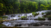
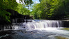


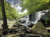

The above images may not be of the site on this page, but were taken nearby. They are loaded from Flickr so please click on them for image credits.
Click here to see more info for this site
Nearby sites
Click here to view sites on an interactive map of the areaKey: Red: member's photo, Blue: 3rd party photo, Yellow: other image, Green: no photo - please go there and take one, Grey: site destroyed
Download sites to:
KML (Google Earth)
GPX (GPS waypoints)
CSV (Garmin/Navman)
CSV (Excel)
To unlock full downloads you need to sign up as a Contributory Member. Otherwise downloads are limited to 50 sites.
Turn off the page maps and other distractions
Nearby sites listing. In the following links * = Image available
54.5km NNW 333° Black Cat Cave Cave or Rock Shelter
62.3km SSE 154° Russell Cave* Cave or Rock Shelter
62.3km SSE 154° Russell Cave Mound* Artificial Mound
77.3km N 351° Sellars Farm* Ancient Village or Settlement
81.0km NW 312° Fewkes* Artificial Mound
88.3km ESE 119° Roxbury Indian Mound* Artificial Mound
90.1km NW 304° Glass Mounds (Tennessee)* Artificial Mound
94.0km NW 307° Old Town (Williamson)* Ancient Village or Settlement
96.9km NW 310° Old Town (Franklin) Ancient Village or Settlement
97.2km NW 321° Tennessee State Museum* Museum
101.5km E 93° Hiwassee Island Mounds* Artificial Mound
103.5km N 350° Castalian Springs Mounds* Artificial Mound
105.7km NE 46° Monterey Standing Stone* Standing Stone (Menhir)
114.0km ESE 105° Candies Creek Village Archaeological Preserve* Ancient Village or Settlement
115.5km NW 309° Mound Bottom* Ancient Village or Settlement
136.1km NNE 13° Skeleton Mountain Snake Effigy Site* Stone Row / Alignment
137.2km S 171° Collinsville Indian Mound* Artificial Mound
137.3km NW 315° Copena Mound Site* Artificial Mound
145.4km SSE 161° Coker Ford Site* Ancient Village or Settlement
151.1km ESE 122° Fort Mountain Stone Enclosure* Cairn
151.4km SW 220° Oakville Mounds* Artificial Mound
161.7km WSW 242° Florence Mound* Artificial Mound
180.9km NNW 337° Page Site, Kentucky* Artificial Mound
189.6km SE 141° Arborrigg* Modern Stone Circle etc
189.9km N 0° Mammoth Cave Kentucky* Cave or Rock Shelter
View more nearby sites and additional images


 We would like to know more about this location. Please feel free to add a brief description and any relevant information in your own language.
 Wir möchten mehr über diese Stätte erfahren. Bitte zögern Sie nicht, eine kurze Beschreibung und relevante Informationen in Deutsch hinzuzufügen.
 Nous aimerions en savoir encore un peu sur les lieux. S'il vous plaît n'hesitez pas à ajouter une courte description et tous les renseignements pertinents dans votre propre langue.
 Quisieramos informarnos un poco más de las lugares. No dude en añadir una breve descripción y otros datos relevantes en su propio idioma.