<< Our Photo Pages >> St David's Well (Perth and Kinross) - Holy Well or Sacred Spring in Scotland in Perth and Kinross
Submitted by KiwiBetsy on Wednesday, 01 December 2004 Page Views: 11698
Springs and Holy WellsSite Name: St David's Well (Perth and Kinross) Alternative Name: Chapel Rock Spring; Fuaran Creig a'Chaibeul; St Cuthbert's Well (Aberfeldy)Country: Scotland County: Perth and Kinross Type: Holy Well or Sacred Spring
Nearest Town: Aberfeldy Nearest Village: Weem
Map Ref: NN84274999
Latitude: 56.627409N Longitude: 3.887965W
Condition:
| 5 | Perfect |
| 4 | Almost Perfect |
| 3 | Reasonable but with some damage |
| 2 | Ruined but still recognisable as an ancient site |
| 1 | Pretty much destroyed, possibly visible as crop marks |
| 0 | No data. |
| -1 | Completely destroyed |
| 5 | Superb |
| 4 | Good |
| 3 | Ordinary |
| 2 | Not Good |
| 1 | Awful |
| 0 | No data. |
| 5 | Can be driven to, probably with disabled access |
| 4 | Short walk on a footpath |
| 3 | Requiring a bit more of a walk |
| 2 | A long walk |
| 1 | In the middle of nowhere, a nightmare to find |
| 0 | No data. |
| 5 | co-ordinates taken by GPS or official recorded co-ordinates |
| 4 | co-ordinates scaled from a detailed map |
| 3 | co-ordinates scaled from a bad map |
| 2 | co-ordinates of the nearest village |
| 1 | co-ordinates of the nearest town |
| 0 | no data |
Internal Links:
External Links:
 (PID:12079)")
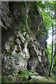
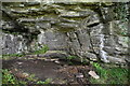
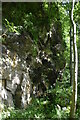
The first recorded inhabitant of the caves was St. Cuthbert who built the stone pool and used to immerse himself in it at night to pray. Unfortunately, a local Princess accused Cuthbert of seducing her so he prayed and the earth swallowed her up. St. Cuthbert had to leave his well and flee the wrath of her father.
The next recorded inhabitant, whose name the well now carries, was David, a 15th century chief of Clan Menzies and owner of nearby Castle Menzies. He gave his lands, including Weem Wood, to the church, took up an austere religious life and lived out his years as a hermit on the bluff by the well.
Park in the Forestry Commission carpark at Weem Wood and take the steadily climbing zig-zagging track to where it reaches a T-intersection and turn right. The path leads along above Weem village to join a circular track that climbs steeply to the bluff high above to follow its ledge past the well and on to descend almost as steeply before swinging back to the original track. The walk takes about an hour and a half but is worth every minute of it. Do take time to notice the forest sculptures and take a coin for the sleeping dragon.
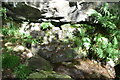
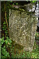
This site is recorded as Canmore ID 25672 which quotes from an 1891 source: "St David's Well lies in a deep recess at the base of an overhanging precipice, the well forming an oblong, 3' x 2' and from 1'6" - 2' deep with an outlet 9" - 10" from the top. The bare rock forms one side and one end, and a large flat stone the other side and end. A quantity of bones was found in front of the deep recess (Hunter 1897). St David is said to have been a former laird of the place, turned monk, who had a chapel at the base of the rock called Craig-an-Teuapail (Creag an t-Seapail)."
The holy well also features on The Northern Antiquarian (TNA) - see their entry for St. David’s Well, Weem, Aberfeldy, Perthshire which gives directions for finding this site together with photographs, a brief archaeology & history and local folklore.
You may be viewing yesterday's version of this page. To see the most up to date information please register for a free account.
 (PID:186990)")
 (PID:186989)")
Do not use the above information on other web sites or publications without permission of the contributor.
Nearby Images from Geograph Britain and Ireland:
©2021(licence)
©2021(licence)
©2021(licence)
©2021(licence)
©2021(licence)
The above images may not be of the site on this page, they are loaded from Geograph.
Please Submit an Image of this site or go out and take one for us!
Click here to see more info for this site
Nearby sites
Key: Red: member's photo, Blue: 3rd party photo, Yellow: other image, Green: no photo - please go there and take one, Grey: site destroyed
Download sites to:
KML (Google Earth)
GPX (GPS waypoints)
CSV (Garmin/Navman)
CSV (Excel)
To unlock full downloads you need to sign up as a Contributory Member. Otherwise downloads are limited to 50 sites.
Turn off the page maps and other distractions
Nearby sites listing. In the following links * = Image available
192m WSW 240° Weem Woods (Dull)* Rock Art (NN841499)
1.4km WSW 242° Weem Cursus Cursus (NN83044939)
1.7km NNE 14° Glassie Standing Stone* Standing Stone (Menhir) (NN84715160)
2.0km WSW 247° Balhomais* Stone Circle (NN82384926)
2.4km W 279° Lurgan* Rock Art (NN8185550425)
2.7km S 170° An Torr* Rock Art (NN84694729)
3.0km ENE 70° Tom-an-Droighne Standing Stone (Menhir) (NN87165094)
3.1km WSW 253° Nether Tullicro* Standing Stone (Menhir) (NN81294916)
3.1km E 80° Carn Tulach* Stone Circle (NN87395045)
3.4km S 175° Coilleachur Stone Circle (NN845466)
3.6km WSW 252° Dull Cairn* Cairn (NN808490)
3.6km E 79° Lundin Standing Stone* Standing Stone (Menhir) (NN87835059)
3.7km WSW 255° Dull Cross (Aberfeldy) Ancient Cross (NN8070649135)
3.8km E 79° Lundin Farm NW* Standing Stones (NN88025062)
3.8km E 80° Lundin Farm* Stone Circle (NN8806650570)
4.1km WSW 256° Appin of Dull* Rock Art (NN803491)
4.2km WSW 251° Carse Farm I* Stone Circle (NN80224873)
4.3km WSW 247° Carse Farm 2* Stone Circle (NN80284846)
4.6km SW 229° St Adamnan's Well* Holy Well or Sacred Spring (NN807471)
4.7km WSW 249° Tirinie Farm Barrow Round Barrow(s) (NN798484)
4.7km WSW 240° Taymouth (2) Standing Stones (NN801477)
4.8km WSW 249° Tirinie Farm Circle Stone Circle (NN797484)
4.9km NE 55° Derculich Passage Grave (NN884527)
5.2km WSW 237° Croft Moraig* Stone Circle (NN79774727)
5.3km WSW 237° Croft Moraig Carving 1 Rock Art (NN7974647251)
View more nearby sites and additional images


 We would like to know more about this location. Please feel free to add a brief description and any relevant information in your own language.
 Wir möchten mehr über diese Stätte erfahren. Bitte zögern Sie nicht, eine kurze Beschreibung und relevante Informationen in Deutsch hinzuzufügen.
 Nous aimerions en savoir encore un peu sur les lieux. S'il vous plaît n'hesitez pas à ajouter une courte description et tous les renseignements pertinents dans votre propre langue.
 Quisieramos informarnos un poco más de las lugares. No dude en añadir una breve descripción y otros datos relevantes en su propio idioma.