


<< Our Photo Pages >> Garrane Stone Row - Stone Row / Alignment in Ireland (Republic of) in Co. Cork
Submitted by Anthony_Weir on Tuesday, 01 October 2002 Page Views: 6741
Neolithic and Bronze AgeSite Name: Garrane Stone RowCountry: Ireland (Republic of) County: Co. Cork Type: Stone Row / Alignment
Nearest Town: Mallow Nearest Village: Bweeng
Map Ref: W478912
Discovery Map Number: D80
Latitude: 52.070799N Longitude: 8.761976W
Condition:
| 5 | Perfect |
| 4 | Almost Perfect |
| 3 | Reasonable but with some damage |
| 2 | Ruined but still recognisable as an ancient site |
| 1 | Pretty much destroyed, possibly visible as crop marks |
| 0 | No data. |
| -1 | Completely destroyed |
| 5 | Superb |
| 4 | Good |
| 3 | Ordinary |
| 2 | Not Good |
| 1 | Awful |
| 0 | No data. |
| 5 | Can be driven to, probably with disabled access |
| 4 | Short walk on a footpath |
| 3 | Requiring a bit more of a walk |
| 2 | A long walk |
| 1 | In the middle of nowhere, a nightmare to find |
| 0 | No data. |
| 5 | co-ordinates taken by GPS or official recorded co-ordinates |
| 4 | co-ordinates scaled from a detailed map |
| 3 | co-ordinates scaled from a bad map |
| 2 | co-ordinates of the nearest village |
| 1 | co-ordinates of the nearest town |
| 0 | no data |
Internal Links:
External Links:
")
A panoramic view across the valley of the river
Blackwater is afforded from this fine alignment (or stone-row),
which comprises 3 stones close together and measuring from 2.5 m to over 3.7 m high. A fourth one has fallen
~2.4km (Just under 1 1/2ml) NNW, about 900m E by N
of Lahuran crossroads, in Gneeves, is another,
unusual, alignment of 3 stones whose broad faces are
parallel, but not in line. The highest is 2.6m.
~1.6km (I ml) due S, and 20m NE of the road from
Bweeng to Lomburdstown, 4.8km (just under 3ml)
NW of Bweeng) is Lackendarragh holed stone. It is
in an enclosure known as Kilkillin (cut through by
the road), which seems to have been an early
Christian graveyard. Nearby is a souterrain. The slab
is 122cm high and 2.7cm thick. At the S edge is a
curving hole, probably formed naturally, 5cms in
diameter, 11.3cm on its long side, and 5cm on its
side. A report in the 19th century alleged that
'handkerchieves' (probably rags) were passed
through it to cure wounds. Skulls have been found
round about, and many local stories of supernatural
moving lights, etc, are associated with the site.
~3.6km (2 1/4ml) SSE is Beenalaght alignment.
~7.2km (4 1/2rnl) ESE is Kilquhane holed stone (see under
Greenhill) .
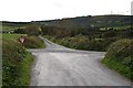
Access: 3.2km (2 ml) NW of
Bweeng and 11.2km (7ml) SW of Mallow, just visible
on the rising slope 200m S of a T-junction at the bridge
over the Duvglasha river.
Note: Photo © Anthony Weir
You may be viewing yesterday's version of this page. To see the most up to date information please register for a free account.
")
")
Do not use the above information on other web sites or publications without permission of the contributor.
Nearby Images from Geograph Britain and Ireland:
©2007(licence)

©2007(licence)

©2007(licence)

©2007(licence)
The above images may not be of the site on this page, they are loaded from Geograph.
Please Submit an Image of this site or go out and take one for us!
Click here to see more info for this site
Nearby sites
Click here to view sites on an interactive map of the areaKey: Red: member's photo, Blue: 3rd party photo, Yellow: other image, Green: no photo - please go there and take one, Grey: site destroyed
Download sites to:
KML (Google Earth)
GPX (GPS waypoints)
CSV (Garmin/Navman)
CSV (Excel)
To unlock full downloads you need to sign up as a Contributory Member. Otherwise downloads are limited to 50 sites.
![]()
Turn off the page maps and other distractions
Nearby sites listing. In the following links * = Image available
435m S 176° Garrane standing stones (pair)* Standing Stones
959m N 357° Lackendarragh Standing Stone* Standing Stone (Menhir)
1.8km NNW 330° Gneeves* Stone Row / Alignment (W469928)
2.4km S 172° Glandine* Standing Stones (W481888)
3.8km SE 125° Beennamweel East wedge tomb* Wedge Tomb
4.0km S 169° Beenalaght* Stone Row / Alignment (W4852387309)
5.1km W 268° Nadanuller More burial ground* Marker Stone
5.3km S 188° Gowlane N* Stone Circle (W470860)
6.4km ESE 120° Lahakinneen standing stone* Standing Stone (Menhir)
7.3km ESE 111° Kilquane Holed Stone* Holed Stone
7.7km S 186° Meenahony north pair* Standing Stones (W46948356)
7.7km S 186° Meenahony south standing stone* Standing Stone (Menhir)
7.8km S 186° Meenahony south pair* Standing Stones (W46928348)
8.2km E 84° Reim Na Gaoithe Stone Circle (W560920)
8.4km SSE 149° Goats Hill anomalous stone group* Standing Stones
8.4km SSW 195° Barrahaurin stone row* Stone Row / Alignment
8.7km ESE 113° Knockantota North Standing Stones (W55818763)
8.8km SE 139° Pluckanes Stone Circle (W53548457)
8.8km ESE 114° Knockantota North* Stone Circle (W55838758)
8.8km SE 139° Pluckanes North Stone Row / Alignment (W536845)
9.2km SSW 197° Kilmartin Lower circle* Stone Circle (W45088242)
9.2km SSW 197° Kilmartin Lower stone* Standing Stone (Menhir)
9.6km SE 140° Pluckanes North standing stone* Standing Stone (Menhir)
9.6km SSW 213° Knocknagoun* Wedge Tomb
10.2km SSW 194° Kilcullen stone pair* Standing Stones (W45158137)
View more nearby sites and additional images


 We would like to know more about this location. Please feel free to add a brief description and any relevant information in your own language.
 Wir möchten mehr über diese Stätte erfahren. Bitte zögern Sie nicht, eine kurze Beschreibung und relevante Informationen in Deutsch hinzuzufügen.
 Nous aimerions en savoir encore un peu sur les lieux. S'il vous plaît n'hesitez pas à ajouter une courte description et tous les renseignements pertinents dans votre propre langue.
 Quisieramos informarnos un poco más de las lugares. No dude en añadir una breve descripción y otros datos relevantes en su propio idioma.