


<< Our Photo Pages >> Cahersavane - Standing Stones in Ireland (Republic of) in Co. Kerry
Submitted by frogcottage42 on Sunday, 04 April 2010 Page Views: 7553
Neolithic and Bronze AgeSite Name: CahersavaneCountry: Ireland (Republic of)
NOTE: This site is 1.2 km away from the location you searched for.
County: Co. Kerry Type: Standing Stones
Nearest Town: Waterville
Map Ref: V5605769610
Latitude: 51.860666N Longitude: 10.090191W
Condition:
| 5 | Perfect |
| 4 | Almost Perfect |
| 3 | Reasonable but with some damage |
| 2 | Ruined but still recognisable as an ancient site |
| 1 | Pretty much destroyed, possibly visible as crop marks |
| 0 | No data. |
| -1 | Completely destroyed |
| 5 | Superb |
| 4 | Good |
| 3 | Ordinary |
| 2 | Not Good |
| 1 | Awful |
| 0 | No data. |
| 5 | Can be driven to, probably with disabled access |
| 4 | Short walk on a footpath |
| 3 | Requiring a bit more of a walk |
| 2 | A long walk |
| 1 | In the middle of nowhere, a nightmare to find |
| 0 | No data. |
| 5 | co-ordinates taken by GPS or official recorded co-ordinates |
| 4 | co-ordinates scaled from a detailed map |
| 3 | co-ordinates scaled from a bad map |
| 2 | co-ordinates of the nearest village |
| 1 | co-ordinates of the nearest town |
| 0 | no data |
Internal Links:
External Links:
I have visited· I would like to visit
frogcottage42 has visited here
")
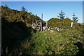
Standing on a rise above cutaway bog, two stones about 100m apart show above relict field walls.
They are shown as 'standing stones' on the OS
The larger of these has fallen toward the West but was probably around 2m tall, it has been incorporated into a field wall which is entirely buried.
The other stone is similarly included within field walls but only remnants are visible.
You may be viewing yesterday's version of this page. To see the most up to date information please register for a free account.
")
Do not use the above information on other web sites or publications without permission of the contributor.
Nearby Images from Geograph Britain and Ireland:

©2021(licence)

©2021(licence)

©2021(licence)

©2021(licence)
©2021(licence)
The above images may not be of the site on this page, they are loaded from Geograph.
Please Submit an Image of this site or go out and take one for us!
Click here to see more info for this site
Nearby sites
Click here to view sites on an interactive map of the areaKey: Red: member's photo, Blue: 3rd party photo, Yellow: other image, Green: no photo - please go there and take one, Grey: site destroyed
Download sites to:
KML (Google Earth)
GPX (GPS waypoints)
CSV (Garmin/Navman)
CSV (Excel)
To unlock full downloads you need to sign up as a Contributory Member. Otherwise downloads are limited to 50 sites.
Turn off the page maps and other distractions
Nearby sites listing. In the following links * = Image available
1.1km NW 312° Dromod Stone Row* Stone Row / Alignment
1.6km W 261° Dromod* Stone Circle (V545694)
1.9km NNE 20° Derrineden W Stone Row / Alignment
2.0km NW 312° Doory standing stone Standing Stone (Menhir)
2.1km NW 309° Doory row* Stone Row / Alignment
2.3km WSW 237° Dromkeare Stone Row / Alignment
2.4km NNE 29° Derrineden E Stone Row / Alignment
6.9km SW 223° Eightercua* Stone Row / Alignment (V51206465)
7.5km WSW 248° Spuncane Stone Circle (V490670)
8.0km SE 140° Staigue* Stone Fort or Dun (V6103463272)
8.7km S 180° Garrough* Stone Row / Alignment
8.9km S 181° Coomnahorna* Standing Stones
9.4km NW 322° Canburrin* Standing Stones (V5047477244)
9.8km SSW 212° Loher Stone Fort* Hillfort
10.1km SE 132° Derreenauliff Stone Row / Alignment
10.1km S 188° Caherdaniel Fort (1)* Stone Fort or Dun (V5434559619)
10.1km S 189° Caherdaniel Fort (2)* Stone Fort or Dun (V5425059627)
10.6km SSE 154° White Strand Modern Stone Circle and Dolmen* Modern Stone Circle etc (V6046959977)
10.8km NNW 340° Srugreana* Standing Stone (Menhir)
10.8km SSW 208° Coomatloukane* Wedge Tomb (V5074660179)
11.0km SSW 191° The Derrynane Stone* Standing Stone (Menhir) (V5356258932)
11.1km WNW 283° Fermoyle Stone Row / Alignment (V453724)
12.7km N 3° Teeromoyle* Standing Stones (V571823)
12.8km NNW 345° Ballynahow Beg* Rock Art (V5305682093)
13.2km NW 314° Cahersiveen standing stones* Standing Stones (V4674478981)
View more nearby sites and additional images


 We would like to know more about this location. Please feel free to add a brief description and any relevant information in your own language.
 Wir möchten mehr über diese Stätte erfahren. Bitte zögern Sie nicht, eine kurze Beschreibung und relevante Informationen in Deutsch hinzuzufügen.
 Nous aimerions en savoir encore un peu sur les lieux. S'il vous plaît n'hesitez pas à ajouter une courte description et tous les renseignements pertinents dans votre propre langue.
 Quisieramos informarnos un poco más de las lugares. No dude en añadir una breve descripción y otros datos relevantes en su propio idioma.