 with our Megalithic Portal iPhone app")


<< Other Photo Pages >> Wellwick Farm (Buckinghamshire) - Ancient Village or Settlement in England in Buckinghamshire
Submitted by Anne T on Thursday, 30 April 2026 Page Views: 204
Multi-periodSite Name: Wellwick Farm (Buckinghamshire)Country: England
NOTE: This site is 0.4 km away from the location you searched for.
County: Buckinghamshire Type: Ancient Village or Settlement
Nearest Town: Wendover Nearest Village: Ellesborough
Map Ref: SP8514008240
Latitude: 51.766376N Longitude: 0.767634W
Condition:
| 5 | Perfect |
| 4 | Almost Perfect |
| 3 | Reasonable but with some damage |
| 2 | Ruined but still recognisable as an ancient site |
| 1 | Pretty much destroyed, possibly visible as crop marks |
| 0 | No data. |
| -1 | Completely destroyed |
| 5 | Superb |
| 4 | Good |
| 3 | Ordinary |
| 2 | Not Good |
| 1 | Awful |
| 0 | No data. |
| 5 | Can be driven to, probably with disabled access |
| 4 | Short walk on a footpath |
| 3 | Requiring a bit more of a walk |
| 2 | A long walk |
| 1 | In the middle of nowhere, a nightmare to find |
| 0 | No data. |
| 5 | co-ordinates taken by GPS or official recorded co-ordinates |
| 4 | co-ordinates scaled from a detailed map |
| 3 | co-ordinates scaled from a bad map |
| 2 | co-ordinates of the nearest village |
| 1 | co-ordinates of the nearest town |
| 0 | no data |
Be the first person to rate this site - see the 'Contribute!' box in the right hand menu.
Internal Links:
External Links:
 (PID:304378)")
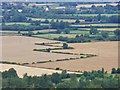
Reported in Current Archaeology, "Murder, monuments, and material wealth uncovered during HS2 works, 11th August 2020", the article tells us "Archaeological work carried out by HS2 archaeologists at Wellwick Farm, Buckinghamshire, has uncovered evidence of activity at the site spanning 4,000 years, from the Neolithic to the medieval period, and including both ceremonial and domestic uses."
"Perhaps the most intriguing find was an Iron Age burial believed to represent the victim of a murder or execution. The skeleton of a man was found face-down in a ditch with his hands placed underneath his pelvis in a position which indicates that they were bound when he was buried. The individual’s remains were dated to the Iron Age using the stratigraphy of the ditch, which also contained pottery and other artefacts. Further research is under way but, given the position in which he was found, it appears that this man may have died a violent and undignified death."
"The team also discovered evidence of a large Neolithic circular monument, 65m in diameter, made up of wooden posts. Excavation identified 146 post-holes in the outer ring, 39 in the inner ring (although it is believed that this circuit would have been complete originally), and five in the centre. The largest of the post-holes, next to the feature’s entrance, are c.0.95m in diameter. This monument is thought to be associated with ceremonial activity of some sort and appears to be aligned with the winter solstice, prompting comparisons with Stonehenge."
"Evidence was also found for Bronze Age and Iron Age domestic occupation at the site. At least one roundhouse was identified, as well as structures that may have been animal pens, and pits for food waste."
"By the Roman period, it seems that occupation may have moved to the current location of Wendover, and that Wellwick Farm was used as a burial site instead. The most important discovery dating to this period is an apparently high-status individual buried within a square enclosure. Their body had been placed inside a lead-lined coffin, which probably once had an outer coffin made of wood as well. Although no grave goods were found, this would have been an expensive mode of burial, and one that contrasts greatly with the unceremonious burial of the Iron Age man."
More information on the archaeology can be found on The Archaeology Data Service, "Data from an Excavation at Wellwick Farm, Wendover, Buckinghamshire, 2019-2020 (HS2 Phase One)". This introductory page gives a summary, then click on 'Downloads' on the left hand side of the page to access the detailed excavation reports.
You may be viewing yesterday's version of this page. To see the most up to date information please register for a free account.
Do not use the above information on other web sites or publications without permission of the contributor.
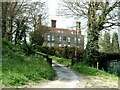
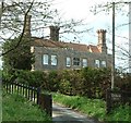
Nearby Images from Geograph Britain and Ireland:
©2017(licence)
©2006(licence)
©2011(licence)
©2011(licence)

©2012(licence)
The above images may not be of the site on this page, they are loaded from Geograph.
Please Submit an Image of this site or go out and take one for us!
Click here to see more info for this site
Nearby sites
Key: Red: member's photo, Blue: 3rd party photo, Yellow: other image, Green: no photo - please go there and take one, Grey: site destroyed
Download sites to:
KML (Google Earth)
GPX (GPS waypoints)
CSV (Garmin/Navman)
CSV (Excel)
To unlock full downloads you need to sign up as a Contributory Member. Otherwise downloads are limited to 50 sites.
Turn off the page maps and other distractions
Nearby sites listing. In the following links * = Image available
1.5km SE 139° Bacombe Hill Barrow Cemetery (SP86160712)
1.5km SE 140° Bacombe Hill Bowl Barrow Round Barrow(s) (SP86130709)
3.1km E 95° Boddington Camp* Hillfort (SP882080)
3.1km SW 224° Ragpit Cross Dyke Misc. Earthwork (SP83020598)
3.3km SW 228° Ragpit Hill Cross Dyke Misc. Earthwork (SP82750601)
3.3km SW 228° Ragpit Cross Dykes Misc. Earthwork (SP82750600)
3.8km SSW 212° Pulpit Hill* Hillfort (SP832050)
5.2km SW 215° Whiteleaf Barrows* Long Barrow (SP82220398)
6.3km S 176° Grim's Ditch Barrows Round Barrow(s) (SP857020)
6.4km SW 222° Princes Risborough Puddingstone* Natural Stone / Erratic / Other Natural Feature (SP80970338)
6.5km NNW 330° Discover Bucks Museum Museum (SP8180113835)
7.1km NNW 349° St. Osyth's Well (Bierton)* Holy Well or Sacred Spring (SP836152)
7.2km NW 308° Hartwell Springs* Holy Well or Sacred Spring (SP7939412589)
7.9km S 170° Stonygreen Puddingstone Natural Stone / Erratic / Other Natural Feature (SP866005)
7.9km E 99° Cholesbury Camp* Hillfort (SP930072)
8.5km S 177° Denner Hill Puddingstone Natural Stone / Erratic / Other Natural Feature (SU857998)
8.8km E 83° Grim’s Ditch (Hertfordshire) Misc. Earthwork (SP93850938)
9.5km SW 231° The Lyde Spring* Holy Well or Sacred Spring (SP778022)
9.8km SE 141° Great Missenden Puddingstone* Natural Stone / Erratic / Other Natural Feature (SP9142700686)
10.0km SW 216° Lodge Hill Round Barrow(s) (SP79400004)
10.0km SW 220° Lodge Hill Barrows Round Barrow(s) (SP78840041)
10.1km SW 215° Lodge Hill Settlement Ancient Village or Settlement (SU79479990)
10.2km SSW 191° Chilterns Grims Ditch* Misc. Earthwork (SU833982)
10.6km SW 229° The Cop (Chinnor) Round Barrow(s) (SP773011)
10.6km SSW 200° Smalldean Round Barrow(s) (SU816982)
View more nearby sites and additional images


 We would like to know more about this location. Please feel free to add a brief description and any relevant information in your own language.
 Wir möchten mehr über diese Stätte erfahren. Bitte zögern Sie nicht, eine kurze Beschreibung und relevante Informationen in Deutsch hinzuzufügen.
 Nous aimerions en savoir encore un peu sur les lieux. S'il vous plaît n'hesitez pas à ajouter une courte description et tous les renseignements pertinents dans votre propre langue.
 Quisieramos informarnos un poco más de las lugares. No dude en añadir una breve descripción y otros datos relevantes en su propio idioma.