


<< Our Photo Pages >> Physic Well (Cumnor) - Holy Well or Sacred Spring in England in Oxfordshire
Submitted by jamesrattue on Friday, 03 May 2019 Page Views: 23657
Springs and Holy WellsSite Name: Physic Well (Cumnor)Country: England
NOTE: This site is 1.5 km away from the location you searched for.
County: Oxfordshire Type: Holy Well or Sacred Spring
Nearest Town: Oxford Nearest Village: Cumnor
Map Ref: SP4412604375
Latitude: 51.736354N Longitude: 1.362401W
Condition:
| 5 | Perfect |
| 4 | Almost Perfect |
| 3 | Reasonable but with some damage |
| 2 | Ruined but still recognisable as an ancient site |
| 1 | Pretty much destroyed, possibly visible as crop marks |
| 0 | No data. |
| -1 | Completely destroyed |
| 5 | Superb |
| 4 | Good |
| 3 | Ordinary |
| 2 | Not Good |
| 1 | Awful |
| 0 | No data. |
| 5 | Can be driven to, probably with disabled access |
| 4 | Short walk on a footpath |
| 3 | Requiring a bit more of a walk |
| 2 | A long walk |
| 1 | In the middle of nowhere, a nightmare to find |
| 0 | No data. |
| 5 | co-ordinates taken by GPS or official recorded co-ordinates |
| 4 | co-ordinates scaled from a detailed map |
| 3 | co-ordinates scaled from a bad map |
| 2 | co-ordinates of the nearest village |
| 1 | co-ordinates of the nearest town |
| 0 | no data |
Internal Links:
External Links:
I have visited· I would like to visit
ulrike would like to visit
Harmudge visited on 26th May 2019 - their rating: Cond: 4 Amb: 4 Access: 4
Bird_nerd29 visited - their rating: Cond: 3 Amb: 4 Access: 3 This took a bit of a long walk, and we walked past it at first - there was a lot of surface water, so looked like it was in a pond. Once we realised and looked closer, it was easier to spot. It's in a nice wooded area, will be going back when it's drier.
Average ratings for this site from all visit loggers: Condition: 3.5 Ambience: 4 Access: 3.5
 (PID:81530)")
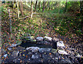
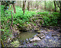
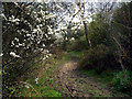
Visitors must take the metalled track that runs westwards from beside the small chapel on the northern edge of the village, out past Long Leys Farm and into a small wood. This is a bridleway and gets quite muddy in wet weather! The path winds through the wood for a couple of hundred yards and the well can be found just off the track on the right-hand (northern) side when walking from Cumnor. It's a tumble of rough stones surrounding a basin of cloudy turqouise water which looks as though it might possibly have some mineral content.
You may be viewing yesterday's version of this page. To see the most up to date information please register for a free account.
 (PID:81528)")
 (PID:23108)")
Do not use the above information on other web sites or publications without permission of the contributor.
Nearby Images from Geograph Britain and Ireland:
©2011(licence)
©2010(licence)
©2010(licence)
©2019(licence)
©2015(licence)
The above images may not be of the site on this page, they are loaded from Geograph.
Please Submit an Image of this site or go out and take one for us!
Click here to see more info for this site
Nearby sites
Key: Red: member's photo, Blue: 3rd party photo, Yellow: other image, Green: no photo - please go there and take one, Grey: site destroyed
Download sites to:
KML (Google Earth)
GPX (GPS waypoints)
CSV (Garmin/Navman)
CSV (Excel)
To unlock full downloads you need to sign up as a Contributory Member. Otherwise downloads are limited to 50 sites.
Turn off the page maps and other distractions
Nearby sites listing. In the following links * = Image available
2.8km WNW 298° Stanton Harcourt Church Cross* Ancient Cross (SP4164305666)
2.9km S 191° Badger's Well* Holy Well or Sacred Spring (SP4360201485)
3.0km W 278° Devils Quoits* Stone Circle (SP4112004760)
3.9km WNW 286° Gravelly Guy Timber Circle (SP404054)
4.0km NNW 334° Deadman's Burial 1 Misc. Earthwork (SP42350795)
4.0km NNW 338° Deadman's Burial 2 Henge (SP42610807)
4.5km NNW 339° Eynsham Timber Circle* Timber Circle (SP4246008580)
4.8km SW 232° Northmoor Linear Ditches* Barrow Cemetery (SP40390142)
5.7km NE 51° St Margaret's Well (Binsey)* Holy Well or Sacred Spring
5.8km W 274° Standlake 20 Timber Circle (SP383047)
7.0km ENE 66° Walton Well* Holy Well or Sacred Spring (SP5047907312)
7.3km ENE 74° Ashmolean Museum of Art and Archaeology* Museum (SP511065)
7.4km ENE 77° Museum of Oxford* Museum (SP513061)
7.4km ENE 69° Radcliffe Infirmary prehistoric monumental landscape Round Barrow(s) (SP5103607101)
7.5km ENE 70° Kendrew Quadrangle* Henge (SP51200695)
7.8km ENE 71° Pitt Rivers Museum* Museum (SP51510695)
8.1km NNE 21° Yarnton* Ancient Village or Settlement (SP4712)
8.2km S 181° Iron Age and Roman Complex at Frilford Ancient Village or Settlement (SU441962)
8.5km NW 326° Eynsham Park Camp Hillfort (SP393114)
9.4km E 84° St Bartholomew's Well Holy Well or Sacred Spring (SP5349805476)
9.5km SSE 147° Abingdon Cursus Cursus (SU494965)
9.8km SE 129° Barrow Hills Radley I Timber Circle (SU518983)
10.5km SW 220° Cherbury Camp* Hillfort (SU374963)
10.7km SSE 152° Drayton North Cursus Cursus (SU492950)
11.3km SSE 156° Drayton South Cursus Cursus (SU489941)
View more nearby sites and additional images


 We would like to know more about this location. Please feel free to add a brief description and any relevant information in your own language.
 Wir möchten mehr über diese Stätte erfahren. Bitte zögern Sie nicht, eine kurze Beschreibung und relevante Informationen in Deutsch hinzuzufügen.
 Nous aimerions en savoir encore un peu sur les lieux. S'il vous plaît n'hesitez pas à ajouter une courte description et tous les renseignements pertinents dans votre propre langue.
 Quisieramos informarnos un poco más de las lugares. No dude en añadir una breve descripción y otros datos relevantes en su propio idioma.