

<< Text Pages >> Pennybridge - Stone Circle in Wales in Pembrokeshire
Submitted by vicky on Sunday, 22 September 2002 Page Views: 7832
Neolithic and Bronze AgeSite Name: PennybridgeCountry: Wales County: Pembrokeshire Type: Stone Circle
Map Ref: SM953001 Landranger Map Number: 158
Latitude: 51.662301N Longitude: 4.961164W
Condition:
| 5 | Perfect |
| 4 | Almost Perfect |
| 3 | Reasonable but with some damage |
| 2 | Ruined but still recognisable as an ancient site |
| 1 | Pretty much destroyed, possibly visible as crop marks |
| 0 | No data. |
| -1 | Completely destroyed |
| 5 | Superb |
| 4 | Good |
| 3 | Ordinary |
| 2 | Not Good |
| 1 | Awful |
| 0 | No data. |
| 5 | Can be driven to, probably with disabled access |
| 4 | Short walk on a footpath |
| 3 | Requiring a bit more of a walk |
| 2 | A long walk |
| 1 | In the middle of nowhere, a nightmare to find |
| 0 | No data. |
| 5 | co-ordinates taken by GPS or official recorded co-ordinates |
| 4 | co-ordinates scaled from a detailed map |
| 3 | co-ordinates scaled from a bad map |
| 2 | co-ordinates of the nearest village |
| 1 | co-ordinates of the nearest town |
| 0 | no data |
Internal Links:
External Links:
Stone Circle in Pembrokeshire
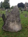
Burl list this as a site as destroyed in his Stone Circle Gazetteer (2000)
Have you visited this site? Please leave a comment below.
You may be viewing yesterday's version of this page. To see the most up to date information please register for a free account.
Do not use the above information on other web sites or publications without permission of the contributor.
Nearby Images from Geograph Britain and Ireland:
©2014(licence)
©2013(licence)

©2007(licence)

©2014(licence)
©2021(licence)
The above images may not be of the site on this page, they are loaded from Geograph.
Please Submit an Image of this site or go out and take one for us!
Click here to see more info for this site
Nearby sites
Key: Red: member's photo, Blue: 3rd party photo, Yellow: other image, Green: no photo - please go there and take one, Grey: site destroyed
Download sites to:
KML (Google Earth)
GPX (GPS waypoints)
CSV (Garmin/Navman)
CSV (Excel)
To unlock full downloads you need to sign up as a Contributory Member. Otherwise downloads are limited to 50 sites.
Turn off the page maps and other distractions
Nearby sites listing. In the following links * = Image available
639m SW 229° Dry Burrows* Barrow Cemetery (SR948997)
1.8km ENE 63° Quoits Wood Ancient Village or Settlement (SM9696000845)
1.9km ENE 70° Bowett Wood Camp Ancient Village or Settlement (SM9713500678)
2.0km W 262° Corston Beacon* Round Barrow(s) (SR933999)
2.5km ENE 68° St Nicholas' Well (Pembroke) Holy Well or Sacred Spring (SM9762800951)
2.7km W 274° Wallaston Green* Barrow Cemetery (SM926004)
2.9km SSW 204° Merrion Court* Hillfort (SR940975)
3.1km NE 54° Priory Farm Cave* Cave or Rock Shelter (SM9789201832)
3.1km ENE 61° Wogan Cavern* Cave or Rock Shelter (SM9810001500)
3.5km ENE 66° Main Street Well* Holy Well or Sacred Spring (SM9858001416)
3.8km E 101° Kingston Cottage Tomb* Chambered Tomb (SR99039924)
3.8km SSE 164° Devil's Quoit (St Twynnells)* Standing Stone (Menhir) (SR96239638)
4.4km NW 313° Pwllcrochan Hillfort (SM922032)
4.5km SSE 159° Harold Stone (Bosherton)* Standing Stone (Menhir) (SR9676095860)
4.8km SE 133° Stackpole enclosure* Ancient Village or Settlement (SR98679665)
5.5km WSW 237° Brownslade Farm Round Barrow(s) (SR905973)
5.6km SSE 159° Bosherston* Hillfort (SR971948)
5.6km SSE 150° Birch Hill Round Barrow(s) (SR979951)
5.7km SSE 150° Fishpond Barrow* Round Barrow(s) (SR97939508)
5.8km SSE 149° Devil's Quoit (Stackpole)* Standing Stone (Menhir) (SR98109503)
5.8km NW 307° Oil Refinery Hillfort (SM908038)
5.9km SSE 152° Stackpole Warren* Ancient Village or Settlement (SR978948)
6.0km SSW 200° Flimston Castle* Promontory Fort / Cliff Castle (SR930946)
6.0km SSE 157° Freynslake Round Barrow(s) (SR974945)
6.0km SSW 194° Crocksydam Camp Hillfort (SR936943)
View more nearby sites and additional images


 We would like to know more about this location. Please feel free to add a brief description and any relevant information in your own language.
 Wir möchten mehr über diese Stätte erfahren. Bitte zögern Sie nicht, eine kurze Beschreibung und relevante Informationen in Deutsch hinzuzufügen.
 Nous aimerions en savoir encore un peu sur les lieux. S'il vous plaît n'hesitez pas à ajouter une courte description et tous les renseignements pertinents dans votre propre langue.
 Quisieramos informarnos un poco más de las lugares. No dude en añadir una breve descripción y otros datos relevantes en su propio idioma.