 with our Megalithic Portal iPhone app")


<< Text Pages >> All Saints (Crofton) - Ancient Cross in England in Yorkshire (West)
Submitted by TimPrevett on Sunday, 20 May 2007 Page Views: 9489
Early MedievalSite Name: All Saints (Crofton)Country: England
NOTE: This site is 4.0 km away from the location you searched for.
County: Yorkshire (West) Type: Ancient Cross
Nearest Village: Crofton
Map Ref: SE37781812
Latitude: 53.658213N Longitude: 1.429804W
Condition:
| 5 | Perfect |
| 4 | Almost Perfect |
| 3 | Reasonable but with some damage |
| 2 | Ruined but still recognisable as an ancient site |
| 1 | Pretty much destroyed, possibly visible as crop marks |
| 0 | No data. |
| -1 | Completely destroyed |
| 5 | Superb |
| 4 | Good |
| 3 | Ordinary |
| 2 | Not Good |
| 1 | Awful |
| 0 | No data. |
| 5 | Can be driven to, probably with disabled access |
| 4 | Short walk on a footpath |
| 3 | Requiring a bit more of a walk |
| 2 | A long walk |
| 1 | In the middle of nowhere, a nightmare to find |
| 0 | No data. |
| 5 | co-ordinates taken by GPS or official recorded co-ordinates |
| 4 | co-ordinates scaled from a detailed map |
| 3 | co-ordinates scaled from a bad map |
| 2 | co-ordinates of the nearest village |
| 1 | co-ordinates of the nearest town |
| 0 | no data |
Be the first person to rate this site - see the 'Contribute!' box in the right hand menu.
Internal Links:
External Links:
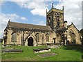
Ancient Cross in Yorkshire (West)
The remains of two Anglo Saxon Crosses at All Saints, Crofton.
You may be viewing yesterday's version of this page. To see the most up to date information please register for a free account.
Do not use the above information on other web sites or publications without permission of the contributor.
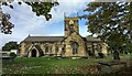
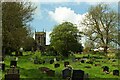
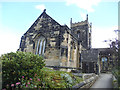
Nearby Images from Geograph Britain and Ireland:
©2015(licence)

©2020(licence)
©2022(licence)
©2023(licence)
©2020(licence)
The above images may not be of the site on this page, they are loaded from Geograph.
Please Submit an Image of this site or go out and take one for us!
Click here to see more info for this site
Nearby sites
Key: Red: member's photo, Blue: 3rd party photo, Yellow: other image, Green: no photo - please go there and take one, Grey: site destroyed
Download sites to:
KML (Google Earth)
GPX (GPS waypoints)
CSV (Garmin/Navman)
CSV (Excel)
To unlock full downloads you need to sign up as a Contributory Member. Otherwise downloads are limited to 50 sites.
Turn off the page maps and other distractions
Nearby sites listing. In the following links * = Image available
5.5km NNW 337° Stanley Ferry Viking Log Boat* Ancient Village or Settlement (SE3560923199)
6.5km NE 39° Featherstone Cursus Cursus (SE418232)
9.1km NNE 33° Castleford Roman Fort and Settlement* Stone Fort or Dun (SE4260025800)
9.2km NE 34° Castleford Museum* Museum (SE4293625772)
9.4km SSE 150° Ringstone Hill (Brierley) Stone Circle (SE42571005)
9.5km SE 144° South Kirby Camp* Hillfort (SE435105)
11.4km ENE 59° Ferrybridge N Timber Circle (SE476240)
11.4km ENE 57° Round Hill Field (Ferrybridge) Cairn (SE47332444)
11.4km ENE 58° Ferrybridge Henge* Henge (SE4746024240)
11.5km ENE 57° Angel Moon Field Cairn (SE47342449)
11.5km ENE 59° Ferrybridge N Timber Circle (SE476241)
11.7km NE 51° Ferry Fryston Chariot Burial* Round Barrow(s) (SE4690025500)
12.4km W 274° St Michael and All Angels (Thornhill)* Ancient Cross (SE25341885)
12.4km NE 47° Ferry Fryston Bronze Age Burial* Barrow Cemetery (SE4680026700)
13.6km SSW 196° Worsborough Common Hillfort (SE340050)
13.7km WNW 285° Dewsbury Minster Ancient Cross (SE245215)
13.8km SW 223° All Saints (Cawthorne)* Ancient Cross (SE28460793)
14.1km ESE 121° Little John's Well (Hampole)* Holy Well or Sacred Spring (SE4988810873)
15.5km ESE 115° Robin Hood's Well (Burghwallis)* Holy Well or Sacred Spring (SE51901175)
16.4km SSW 203° Stainborough Castle* Hillfort (SE315030)
16.8km NNW 335° St Peter's Minster Church (Kirkgate)* Ancient Cross (SE30653330)
16.9km NNW 331° St Helen's Well (Holbeck) Holy Well or Sacred Spring (SE295329)
16.9km NNW 337° Quarry Hill (Leeds) Ancient Village or Settlement (SE309336)
17.2km NNW 336° Lady Well (Leeds) Holy Well or Sacred Spring (SE30603373)
17.7km NNW 334° Leeds City Museum* Museum (SE2993634036)
View more nearby sites and additional images


 We would like to know more about this location. Please feel free to add a brief description and any relevant information in your own language.
 Wir möchten mehr über diese Stätte erfahren. Bitte zögern Sie nicht, eine kurze Beschreibung und relevante Informationen in Deutsch hinzuzufügen.
 Nous aimerions en savoir encore un peu sur les lieux. S'il vous plaît n'hesitez pas à ajouter une courte description et tous les renseignements pertinents dans votre propre langue.
 Quisieramos informarnos un poco más de las lugares. No dude en añadir una breve descripción y otros datos relevantes en su propio idioma.