


<< Our Photo Pages >> St Mungo's Well (Cumbria) - Holy Well or Sacred Spring in England in Cumbria
Submitted by vicky on Sunday, 28 November 2004 Page Views: 14098
Springs and Holy WellsSite Name: St Mungo's Well (Cumbria) Alternative Name: St Kentigern's Well (Caldbeck)Country: England
NOTE: This site is 4.458 km away from the location you searched for.
County: Cumbria Type: Holy Well or Sacred Spring
Nearest Town: Carlisle Nearest Village: Caldbeck
Map Ref: NY3251339910 Landranger Map Number: 90
Latitude: 54.749590N Longitude: 3.049994W
Condition:
| 5 | Perfect |
| 4 | Almost Perfect |
| 3 | Reasonable but with some damage |
| 2 | Ruined but still recognisable as an ancient site |
| 1 | Pretty much destroyed, possibly visible as crop marks |
| 0 | No data. |
| -1 | Completely destroyed |
| 5 | Superb |
| 4 | Good |
| 3 | Ordinary |
| 2 | Not Good |
| 1 | Awful |
| 0 | No data. |
| 5 | Can be driven to, probably with disabled access |
| 4 | Short walk on a footpath |
| 3 | Requiring a bit more of a walk |
| 2 | A long walk |
| 1 | In the middle of nowhere, a nightmare to find |
| 0 | No data. |
| 5 | co-ordinates taken by GPS or official recorded co-ordinates |
| 4 | co-ordinates scaled from a detailed map |
| 3 | co-ordinates scaled from a bad map |
| 2 | co-ordinates of the nearest village |
| 1 | co-ordinates of the nearest town |
| 0 | no data |
Internal Links:
External Links:
I have visited· I would like to visit
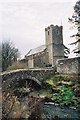
Anne T visited on 14th Aug 2018 - their rating: Cond: 3 Amb: 4 Access: 4 St Kentigern's Well, Caldbeck: This was our last stop of the day, and to a part of Cumbria we've never travelled through before. From St. Bridget's in Brigham, we followed the B5299 to Caldbeck village, which took us over cattle grids and moorlands, with only sheep and the occasional other car in sight.
Caldbeck is a really pretty little village, and we resolved to come back during the daytime, when the shops, church and café were open.
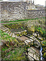
The well can be easily found by walking down the footpath to the west of the church, until you get to the bridge over the river. As it says in the "Holy Wells of Cumbria" booklet, turn left just before the bridge, and you immediately come to some steps down the (steep-ish) bank to the river. We heard the trickle of water down the slope, and the well basin comes into view as you look down. At the time of our visit the water missed the basin and was trickling down the rock, under the shrubbery, into the river. There was a fair flow of water coming down the bank.
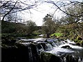
We walked along the footpath along the northern side of the churchyard for about 100mand found a lovely weir with small waterfalls. It was possible to walk down to the gravel beach. A lovely spot indeed.
ocifant have visited here
 (PID:14967)")
This well is described in the "Holy Wells of Cumbria" booklet by the Cumbria Holy Wells Trust 2008.
The well can be reached by walking down the footpath at the western side of St. Kentigern's Church. As you reach the bridge over the river, a footpath heads off to your left. Step onto the footpath and look down; a set of stone steps leads down the slope to the river, with the well basin to their left hand side.
The Holy Wells booklet describes this as "restored and beautifully cared for … there was a long tradition of St Kentigern preaching and baptising here."
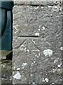
This holy well is recorded as Pastscape Monument No 10481, which describes the well as having first being mentioned in 1231 and is "a stone lined basin approx. 1m square filled with water issuing from the bank." Pastscape gives the grid reference as NY 3248 3989, but the well is nearer the church and the bridge, at NY 32513 39910, some 40 metres to the east-north-east.
You may be viewing yesterday's version of this page. To see the most up to date information please register for a free account.
 (PID:185071)")
 (PID:185070)")
 (PID:185069)")
Do not use the above information on other web sites or publications without permission of the contributor.
Nearby Images from Geograph Britain and Ireland:
©2015(licence)
©2008(licence)
©2005(licence)
©2022(licence)
©2022(licence)
The above images may not be of the site on this page, they are loaded from Geograph.
Please Submit an Image of this site or go out and take one for us!
Click here to see more info for this site
Nearby sites
Key: Red: member's photo, Blue: 3rd party photo, Yellow: other image, Green: no photo - please go there and take one, Grey: site destroyed
Download sites to:
KML (Google Earth)
GPX (GPS waypoints)
CSV (Garmin/Navman)
CSV (Excel)
To unlock full downloads you need to sign up as a Contributory Member. Otherwise downloads are limited to 50 sites.
Turn off the page maps and other distractions
Nearby sites listing. In the following links * = Image available
3.1km WNW 282° Faulds Brow Holed stone and Enclosure* Holed Stone (NY2950340623)
3.2km WNW 282° Faulds Brow Banked Cairn Cairn (NY2937140629)
3.3km W 263° Faulds Brow Standing stones alignment* Stone Row / Alignment (NY2919339540)
3.4km W 276° Faulds Brow Banjo Enclosure* Misc. Earthwork (NY2912340331)
4.7km SSE 168° Williwood Well Round Cairn Round Cairn (NY3343835291)
5.0km SSE 154° Weasel Hills Cairnfield* Round Cairn (NY3461435382)
5.5km SSE 160° Rospow Hills Cairn Field Barrow Cemetery (NY3428834698)
5.7km SSE 152° High Wath Ford Round Cairn North* Round Cairn (NY3512034821)
5.7km SSE 152° High Wath Ford Round Cairn South* Round Cairn (NY3510134773)
5.9km WSW 254° Aughertree Fell outlier standing stones* Stone Row / Alignment (NY2675338384)
6.2km SSE 153° Linewath Round Cairn* Round Cairn (NY3522434360)
6.2km WSW 252° Aughertree Fell stone circle* Stone Circle (NY2658138140)
6.3km S 171° Round Knott Cairn (NY334337)
6.5km SSE 164° Carrock Fell* Hillfort (NY342336)
6.6km WSW 250° Aughertree fell standing stones* Standing Stones (NY2627837699)
6.7km WSW 259° Daleside Tumulus* Round Barrow(s) (NY259387)
6.7km SSE 154° Apronful of Stones (Carrock Fell)* Natural Stone / Erratic / Other Natural Feature (NY3535533799)
6.8km SSE 155° Mungrisedale Cairn (NY3530033700)
7.2km WSW 250° Green How Enclosure* Causewayed Enclosure (NY25753751)
7.3km N 9° Shawk Quarries Holy Well (Dalston) Holy Well or Sacred Spring (NY3380047100)
7.5km N 10° St Michael's Well (Shawk)* Holy Well or Sacred Spring (NY3395047280)
8.7km ENE 65° High Head Sculpture Valley Stone Circle* Modern Stone Circle etc (NY405435)
9.6km WSW 251° High Ireby Standing Stone* Standing Stone (Menhir) (NY234369)
10.1km W 266° Ireby Old Church* Ancient Cross (NY2238839305)
11.0km ENE 64° Broad Field Stone Circle (NY425445)
View more nearby sites and additional images


 We would like to know more about this location. Please feel free to add a brief description and any relevant information in your own language.
 Wir möchten mehr über diese Stätte erfahren. Bitte zögern Sie nicht, eine kurze Beschreibung und relevante Informationen in Deutsch hinzuzufügen.
 Nous aimerions en savoir encore un peu sur les lieux. S'il vous plaît n'hesitez pas à ajouter une courte description et tous les renseignements pertinents dans votre propre langue.
 Quisieramos informarnos un poco más de las lugares. No dude en añadir una breve descripción y otros datos relevantes en su propio idioma.