

<< Our Photo Pages >> Easter Pitcorthie - Standing Stone (Menhir) in Scotland in Fife
Submitted by Nick on Sunday, 14 December 2003 Page Views: 10748
Neolithic and Bronze AgeSite Name: Easter PitcorthieCountry: Scotland
NOTE: This site is 3.5 km away from the location you searched for.
County: Fife Type: Standing Stone (Menhir)
Nearest Town: Elie Nearest Village: Easter Pitcorthie
Map Ref: NO497039 Landranger Map Number: 59
Latitude: 56.224987N Longitude: 2.812801W
Condition:
| 5 | Perfect |
| 4 | Almost Perfect |
| 3 | Reasonable but with some damage |
| 2 | Ruined but still recognisable as an ancient site |
| 1 | Pretty much destroyed, possibly visible as crop marks |
| 0 | No data. |
| -1 | Completely destroyed |
| 5 | Superb |
| 4 | Good |
| 3 | Ordinary |
| 2 | Not Good |
| 1 | Awful |
| 0 | No data. |
| 5 | Can be driven to, probably with disabled access |
| 4 | Short walk on a footpath |
| 3 | Requiring a bit more of a walk |
| 2 | A long walk |
| 1 | In the middle of nowhere, a nightmare to find |
| 0 | No data. |
| 5 | co-ordinates taken by GPS or official recorded co-ordinates |
| 4 | co-ordinates scaled from a detailed map |
| 3 | co-ordinates scaled from a bad map |
| 2 | co-ordinates of the nearest village |
| 1 | co-ordinates of the nearest town |
| 0 | no data |
Internal Links:
External Links:
")
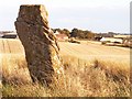
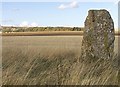
Just off the B942 near Kilconquhar is Easter Pitcorthie farm, just to the west of which is a large standing stone. Obtaining permission at the farm house, I walked across a newly harrowed field to the stone itself. This farmer is careful to leave a good large area unploughed round the stone, unlike too many others. Two skylarks were singing their hearts out above me as I walked to the stone and back. The stone itself is of red sandstone, nearly 8 feet tall, with a pronounced eastward slant, and is very prominent in the landscape, though it cannot be seen from the road. There are many cup marks on the southern face, but some of these are severely eroded. During excavations back in the 1850s, ashes and the remains of human bones were discovered interred beneath the stone.
You may be viewing yesterday's version of this page. To see the most up to date information please register for a free account.
Do not use the above information on other web sites or publications without permission of the contributor.
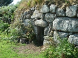
Nearby Images from Geograph Britain and Ireland:
©2005(licence)
©2007(licence)
©2012(licence)

©2009(licence)

©2017(licence)
The above images may not be of the site on this page, they are loaded from Geograph.
Please Submit an Image of this site or go out and take one for us!
Click here to see more info for this site
Nearby sites
Key: Red: member's photo, Blue: 3rd party photo, Yellow: other image, Green: no photo - please go there and take one, Grey: site destroyed
Download sites to:
KML (Google Earth)
GPX (GPS waypoints)
CSV (Garmin/Navman)
CSV (Excel)
To unlock full downloads you need to sign up as a Contributory Member. Otherwise downloads are limited to 50 sites.
Turn off the page maps and other distractions
Nearby sites listing. In the following links * = Image available
3.0km SSE 166° Ardross souterrain* Souterrain (Fogou, Earth House) (NO5037500950)
5.5km ESE 104° St Fillan's Well (Pittenweem)* Holy Well or Sacred Spring (NO550025)
7.4km W 266° Largo Pictish Stone* Class II Pictish Symbol Stone (NO42340347)
7.4km E 84° Skeith Stone* Class II Pictish Symbol Stone (NO571046)
7.8km NNE 24° Dunino Stone Circle (NO530110)
8.1km NNE 31° Druid's Well (Dunino)* Holy Well or Sacred Spring (NO540108)
8.1km ENE 66° West Pitcorthie* Standing Stone (Menhir) (NO572071)
8.2km NNE 31° Dunino Den* Stone Row / Alignment (NO540109)
9.3km W 262° Lundin Links* Stone Circle (NO40480272)
9.4km WNW 290° Norrie's Law* Round Barrow(s) (NO409073)
10.0km NNW 337° Drumcarrow Craig* Broch or Nuraghe (NO459132)
10.3km ENE 79° Caiplie* Class I Pictish Symbol Stone (NO599058)
10.9km NNE 30° Boarhills* Standing Stone (Menhir) (NO5525413356)
12.0km W 267° Aithernie (Scoonie) Cairn (NO37690339)
12.0km ENE 70° Sauchope* Class III Pictish Cross Slab (NO61040788)
12.1km N 1° St. Andrews Museum* Museum (NO5016)
12.2km W 265° Balgrummo* Standing Stone (Menhir) (NO375029)
12.2km NW 307° Spout Well* Holy Well or Sacred Spring (NO400114)
12.3km ENE 70° Devil's Blue Stane* Standing Stone (Menhir) (NO614079)
12.6km ENE 71° Briery Well* Holy Well or Sacred Spring (NO617078)
12.8km N 7° Monk's Well, St Andrews* Holy Well or Sacred Spring (NO514166)
12.8km N 3° The Blue Stane (St Andrews)* Standing Stone (Menhir) (NO5055216707)
16.4km WSW 246° Sloping Cave* Cave or Rock Shelter (NT34619727)
16.6km WSW 245° Well Cave (East Wemyss)* Cave or Rock Shelter (NT345971)
16.7km WSW 245° Jonathan’s Cave* Cave or Rock Shelter (NT344970)
View more nearby sites and additional images


 We would like to know more about this location. Please feel free to add a brief description and any relevant information in your own language.
 Wir möchten mehr über diese Stätte erfahren. Bitte zögern Sie nicht, eine kurze Beschreibung und relevante Informationen in Deutsch hinzuzufügen.
 Nous aimerions en savoir encore un peu sur les lieux. S'il vous plaît n'hesitez pas à ajouter une courte description et tous les renseignements pertinents dans votre propre langue.
 Quisieramos informarnos un poco más de las lugares. No dude en añadir una breve descripción y otros datos relevantes en su propio idioma.