 with our Megalithic Portal iPhone app")


<< Our Photo Pages >> Dark Stane Roundie - Round Barrow(s) in Scotland in Angus
Submitted by Nick on Monday, 03 November 2003 Page Views: 10149
Neolithic and Bronze AgeSite Name: Dark Stane RoundieCountry: Scotland County: Angus Type: Round Barrow(s)
Nearest Town: Dundee
Map Ref: NO362310 Landranger Map Number: 54
Latitude: 56.466796N Longitude: 3.037072W
Condition:
| 5 | Perfect |
| 4 | Almost Perfect |
| 3 | Reasonable but with some damage |
| 2 | Ruined but still recognisable as an ancient site |
| 1 | Pretty much destroyed, possibly visible as crop marks |
| 0 | No data. |
| -1 | Completely destroyed |
| 5 | Superb |
| 4 | Good |
| 3 | Ordinary |
| 2 | Not Good |
| 1 | Awful |
| 0 | No data. |
| 5 | Can be driven to, probably with disabled access |
| 4 | Short walk on a footpath |
| 3 | Requiring a bit more of a walk |
| 2 | A long walk |
| 1 | In the middle of nowhere, a nightmare to find |
| 0 | No data. |
| 5 | co-ordinates taken by GPS or official recorded co-ordinates |
| 4 | co-ordinates scaled from a detailed map |
| 3 | co-ordinates scaled from a bad map |
| 2 | co-ordinates of the nearest village |
| 1 | co-ordinates of the nearest town |
| 0 | no data |
Internal Links:
External Links:
")
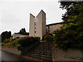
Park at the foot of the hill - just off the Ninewells access roundabout, on the south side, is a small residential area where there is usually parking space. Walk up the drive towards the hospital, and as you pass the first curve you'll see the cairn on your right. This cairn or barrow is described thus in Canmore: "A small circular, wooded enclosure on Menzieshill farm, known locally as "Dark Stane" Roundie, derived its name from a large upright block of dark whinstone, standing near its centre, almost enveloped in foliage. It has been suggested that it formed part of a stone circle, and when it was removed in 1888, a quantity of bones was ploughed up at the spot where it stood. Further human bones were found all over the Roundie when it was ploughed over. The stone was about 7' high, 4' broad and 1' thick, entirely unsculptured, but fairly smooth on the sides which faced east and west. A large piece lying on the ground was said to have been struck off by lightning." The stone has long since gone, as has the wood. On the top of the cairn now are a few small stones, which look like Victorian railing supports - only 4 of a possible 7 or 8 are left, all with small holes facing outward. There's not much left to look at, and it is now almost surrounded by roads and housing developments.
You may be viewing yesterday's version of this page. To see the most up to date information please register for a free account.
")
")
Do not use the above information on other web sites or publications without permission of the contributor.
Nearby Images from Geograph Britain and Ireland:
©2021(licence)
©2021(licence)
©2021(licence)
©2016(licence)
©2021(licence)
The above images may not be of the site on this page, they are loaded from Geograph.
Please Submit an Image of this site or go out and take one for us!
Click here to see more info for this site
Nearby sites
Key: Red: member's photo, Blue: 3rd party photo, Yellow: other image, Green: no photo - please go there and take one, Grey: site destroyed
Download sites to:
KML (Google Earth)
GPX (GPS waypoints)
CSV (Garmin/Navman)
CSV (Excel)
To unlock full downloads you need to sign up as a Contributory Member. Otherwise downloads are limited to 50 sites.
Turn off the page maps and other distractions
Nearby sites listing. In the following links * = Image available
1.1km NW 304° Balgarthno* Stone Circle (NO35333161)
1.6km W 270° Devil's Stone (Perth & Kinross)* Standing Stone (Menhir) (NO3458131019)
1.7km SW 234° St Peter's Church (Invergowrie)* Early Christian Sculptured Stone (NO348300)
2.0km NNW 339° Camperdown Standing Stone* Standing Stone (Menhir) (NO3549632905)
2.0km W 267° Longforgan Cursus Cursus (NO34163094)
2.1km W 266° Longforgan Cursus Cursus (NO34123090)
2.9km WSW 251° Mylnefield Stone Circle (NO334301)
3.5km WNW 300° Hurly Hawkins* Broch or Nuraghe (NO332328)
4.0km NW 315° Liff and Benvie Cursus Cursus (NO33403391)
4.1km E 97° McManus Galleries* Museum (NO40253047)
4.2km NW 314° Liff and Benvie Cursus Cursus (NO33263396)
4.5km NNE 20° Strathmartine 3 Class II Pictish Symbol Stone (NO378352)
5.0km N 351° Templelands (Auchterhouse) Stone Circle (NO355360)
5.8km W 269° Longforgan Cursus Cursus (NO30353100)
6.3km S 183° Monk's Well (Balmerino)* Holy Well or Sacred Spring (NO358247)
6.7km W 268° Falcon Stone* Standing Stone (Menhir) (NO295309)
6.7km N 10° Balluderon* Class II Pictish Symbol Stone (NO37483758)
7.0km W 267° Rossie Mercat Cross 1746 Ancient Cross (NO2920830732)
7.0km W 267° Rossie Priory Class II Pictish Symbol Stone (NO292308)
7.0km W 267° Rossie Loupin-on Stane* Standing Stone (Menhir) (NO2917630741)
7.3km N 0° Balkello Standing Stone* Standing Stone (Menhir) (NO36333830)
7.7km NNE 14° Balkemback* Stone Circle (NO382384)
7.9km WSW 258° Moncur Castle* Standing Stone (Menhir) (NO2836929520)
8.4km NNW 347° Auchterhouse Standing Stones (NO345392)
8.4km NNW 348° Witches Stone (Auchterhouse) Stone Circle (NO34603928)
View more nearby sites and additional images


 We would like to know more about this location. Please feel free to add a brief description and any relevant information in your own language.
 Wir möchten mehr über diese Stätte erfahren. Bitte zögern Sie nicht, eine kurze Beschreibung und relevante Informationen in Deutsch hinzuzufügen.
 Nous aimerions en savoir encore un peu sur les lieux. S'il vous plaît n'hesitez pas à ajouter une courte description et tous les renseignements pertinents dans votre propre langue.
 Quisieramos informarnos un poco más de las lugares. No dude en añadir una breve descripción y otros datos relevantes en su propio idioma.