



Lendrick Lodge
Submitted by hamish on Tuesday, 29 November 2005 Page Views: 10676
Neolithic and Bronze AgeSite Name: Lendrick LodgeCountry: Scotland County: Angus Type: Standing Stone (Menhir)
Nearest Town: Kirriemuir Nearest Village: Craigton
Map Ref: NO350504
Latitude: 56.640889N Longitude: 3.061412W
Condition:
| 5 | Perfect |
| 4 | Almost Perfect |
| 3 | Reasonable but with some damage |
| 2 | Ruined but still recognisable as an ancient site |
| 1 | Pretty much destroyed, possibly visible as crop marks |
| 0 | No data. |
| -1 | Completely destroyed |
| 5 | Superb |
| 4 | Good |
| 3 | Ordinary |
| 2 | Not Good |
| 1 | Awful |
| 0 | No data. |
| 5 | Can be driven to, probably with disabled access |
| 4 | Short walk on a footpath |
| 3 | Requiring a bit more of a walk |
| 2 | A long walk |
| 1 | In the middle of nowhere, a nightmare to find |
| 0 | No data. |
| 5 | co-ordinates taken by GPS or official recorded co-ordinates |
| 4 | co-ordinates scaled from a detailed map |
| 3 | co-ordinates scaled from a bad map |
| 2 | co-ordinates of the nearest village |
| 1 | co-ordinates of the nearest town |
| 0 | no data |
Internal Links:


External Links:


I have visited· I would like to visit
hamish has visited here

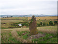
Leave Kirriemuir on the A926 westbound, turn down the second un-numbered road on the left - at the crossroads turn right and park outside Lendrick Lodge. There is a field gate opposite, follow the right hand field hedge then bear right to the rise and you will see the stone.
The Lady of the house is involved in Prehistoric conservation and says that the stone was removed by a "progressive" farmer and dumped at the side of the field. He was told by Historic Scotland to put it back in its place and there it stands, Good old HS.
She also said I should say hello to Nick Brand, so, hello Nick.
You may be viewing yesterday's version of this page. To see the most up to date information please register for a free account.


Do not use the above information on other web sites or publications without permission of the contributor.
Nearby Images from Geograph Britain and Ireland:
©2008(licence)
©2007(licence)
©2016(licence)
©2021(licence)
©2007(licence)
The above images may not be of the site on this page, they are loaded from Geograph.
Please Submit an Image of this site or go out and take one for us!
Click here to see more info for this site
Log in or create a free account to see nearby ancient sites our visitors rate highly
All Nearby sites
 Click here to view sites on an interactive OS map
Download sites to:
KML (Google Earth)
GPX (GPS waypoints)
CSV (Garmin/Navman)
CSV (Excel)
To unlock full downloads you need to sign up as a Society Member. Otherwise downloads are limited to 50 sites.
Turn off the page maps and other distractions
Nearby sites listing. In the following links * = Image available
969m NE 40° Airlie Cursus Cursus (NO35645113)
1.1km NNE 33° Airlie Cursus Cursus (NO35605130)
2.1km W 272° Carlin Well (Craigton of Airlie) Holy Well or Sacred Spring (NO3289850521)
2.9km W 266° Airlie* Standing Stone (Menhir) (NO3208450249)
2.9km S 173° Eassie* Class II Pictish Symbol Stone (NO353475)
3.0km S 174° Eassie Stone* Class II Pictish Symbol Stone (NO35264745)
4.8km W 263° Philpie Stones* Standing Stone (Menhir) (NO302499)
4.9km NW 319° Meikle Kenny C* Stone Circle (NO31825418)
4.9km NW 319° Meikle Kenny B* Stone Circle (NO31805417)
4.9km NW 318° Meikle Kenny A* Stone Circle (NO31765415)
5.0km SE 133° St Fergus's Well* Holy Well or Sacred Spring (NO386469)
5.0km SE 134° Glamis 2* Class I / Class II Hybrid Pictish Symbol Stone (NO38584686)
5.1km E 93° Cossans* Class II Pictish Symbol Stone (NO4008350019)
5.1km SE 133° Glamis 3 Class III Pictish Cross Slab (NO387469)
5.5km ENE 67° Fletcherfield Standing Stones (NO401525)
5.5km NNE 34° Rocking Stones (Kirriemuir) Natural Stone / Erratic / Other Natural Feature (NO38135496)
5.8km N 2° Culhawk Hill Stone Circle (NO353562)
5.8km SE 131° Glamis 1* Class I / Class II Hybrid Pictish Symbol Stone (NO39374654)
5.9km NE 44° Kirriemuir Stone Circle* Stone Circle (NO39175463)
6.0km W 269° Bruceton* Class I Pictish Symbol Stone (NO290504)
6.8km NNE 30° Caddam (Kirriemuir)* Standing Stone (Menhir) (NO38485625)
6.8km NNE 30° Caddam* Standing Stone (Menhir) (NO385563)
6.9km ENE 74° Balinshoe Standing Stone (Menhir) (NO41645219)
7.0km W 272° Drumderrach* Standing Stones (NO280507)
7.0km W 272° Shanzie Standing Stone (Menhir) (NO280507)
View more nearby sites and additional images


 We would like to know more about this location. Please feel free to add a brief description and any relevant information in your own language.
 Wir möchten mehr über diese Stätte erfahren. Bitte zögern Sie nicht, eine kurze Beschreibung und relevante Informationen in Deutsch hinzuzufügen.
 Nous aimerions en savoir encore un peu sur les lieux. S'il vous plaît n'hesitez pas à ajouter une courte description et tous les renseignements pertinents dans votre propre langue.
 Quisieramos informarnos un poco más de las lugares. No dude en añadir una breve descripción y otros datos relevantes en su propio idioma.