

<< Our Photo Pages >> Briskemoen - Barrow Cemetery in Norway in Telemark
Submitted by kenntha88 on Saturday, 21 October 2023 Page Views: 141
Neolithic and Bronze AgeSite Name: BriskemoenCountry: Norway
NOTE: This site is 3.471 km away from the location you searched for.
Fylke: Telemark Type: Barrow Cemetery
Nearest Town: Skien Nearest Village: Gvarv
Latitude: 59.416791N Longitude: 9.309022E
Condition:
| 5 | Perfect |
| 4 | Almost Perfect |
| 3 | Reasonable but with some damage |
| 2 | Ruined but still recognisable as an ancient site |
| 1 | Pretty much destroyed, possibly visible as crop marks |
| 0 | No data. |
| -1 | Completely destroyed |
| 5 | Superb |
| 4 | Good |
| 3 | Ordinary |
| 2 | Not Good |
| 1 | Awful |
| 0 | No data. |
| 5 | Can be driven to, probably with disabled access |
| 4 | Short walk on a footpath |
| 3 | Requiring a bit more of a walk |
| 2 | A long walk |
| 1 | In the middle of nowhere, a nightmare to find |
| 0 | No data. |
| 5 | co-ordinates taken by GPS or official recorded co-ordinates |
| 4 | co-ordinates scaled from a detailed map |
| 3 | co-ordinates scaled from a bad map |
| 2 | co-ordinates of the nearest village |
| 1 | co-ordinates of the nearest town |
| 0 | no data |
Internal Links:
External Links:
")
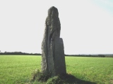
The cemetery consists of 9 barrows, six round barrows and 3 long barrows. They are oriented in two groups. One to the north west and one to the south east. The north east group have 3 beautiful round barrows. One is 12 metres in diameter and 1,7 metres in height, The next barrow is 14 metres in diameter and 2 metres in height and the third one is 13 metres in diameter and 1,5 metres in height. This barrow seems undamaged and have a very beautiful profile. All the barrows have the typical ditch around them and all are easy to see on the right side of the footpath.
The south east group consists of three round barrows and three long barrows. The long barrows are oriented in a line from NW to SE with the narrow ends after one another. They are all of similar size, from 12-15 metres in length, 3-4 metres wide and 1-1,5 metres in height. They are paralell to the footpath and the round barrows. The round barrows in the south east part are 10, 11 and 9 metres in diameter and 1,5 to 1,8 metres in height. They are also easy to see in the terrain and have very beautiful rounded profiles and clear ditches around them.
You may be viewing yesterday's version of this page. To see the most up to date information please register for a free account.
")
")
")
")
")
")
")
")
")
")
")
")
")
")
Do not use the above information on other web sites or publications without permission of the contributor.
Click here to see more info for this site
Nearby sites
Click here to view sites on an interactive map of the areaKey: Red: member's photo, Blue: 3rd party photo, Yellow: other image, Green: no photo - please go there and take one, Grey: site destroyed
Download sites to:
KML (Google Earth)
GPX (GPS waypoints)
CSV (Garmin/Navman)
CSV (Excel)
To unlock full downloads you need to sign up as a Contributory Member. Otherwise downloads are limited to 50 sites.
Turn off the page maps and other distractions
Nearby sites listing. In the following links * = Image available
7.0km SW 225° Neshaugen* Round Barrow(s)
7.1km WSW 242° Nesbyen-Tinghaug* Modern Stone Circle etc
9.1km WSW 253° Håtveit Barrows* Round Barrow(s)
9.2km W 264° Leikvang* Barrow Cemetery
9.6km W 274° Gullhaugen-Alstadhaug* Round Barrow(s)
11.5km W 276° Gåra Gravfelt* Barrow Cemetery
11.7km W 273° Steinmerra* Rock Art
12.7km W 268° Grivi* Round Barrow(s)
16.0km W 277° Breskelivegen* Round Barrow(s)
16.5km W 276° Breskelimogane* Barrow Cemetery
17.4km W 265° Trellsborg hillfort* Hillfort
18.3km NNW 341° Semhaugen* Round Barrow(s)
19.8km SSW 212° Tyri-Vedlandsvegen* Barrow Cemetery
23.1km SE 138° Nøklegård* Round Barrow(s)
23.4km SE 140° Nord-Tufte-Foss* Barrow Cemetery
24.1km SE 140° Fossum Helleristninger* Rock Art
24.2km SE 140° Sør-Tufte* Barrow Cemetery
24.3km SE 140° Luksefjellvegen* Round Barrow(s)
24.6km SE 139° Berland Barrow Cemetery* Barrow Cemetery
26.7km ESE 122° Siljuhaugen* Round Barrow(s)
27.2km SE 141° Gjerpen Skole* Rock Art
28.6km SSE 147° Kjempa Hillfort* Hillfort
28.8km NE 44° Knatten* Barrow Cemetery
29.3km SSE 147° Galgeholmen* Round Barrow(s)
30.2km SSE 150° Gimsø Kloster* Barrow Cemetery
View more nearby sites and additional images


 We would like to know more about this location. Please feel free to add a brief description and any relevant information in your own language.
 Wir möchten mehr über diese Stätte erfahren. Bitte zögern Sie nicht, eine kurze Beschreibung und relevante Informationen in Deutsch hinzuzufügen.
 Nous aimerions en savoir encore un peu sur les lieux. S'il vous plaît n'hesitez pas à ajouter une courte description et tous les renseignements pertinents dans votre propre langue.
 Quisieramos informarnos un poco más de las lugares. No dude en añadir una breve descripción y otros datos relevantes en su propio idioma.