

<< Text Pages >> Sufetula - Ancient Village or Settlement in Tunisia
Submitted by AlexHunger on Saturday, 16 February 2008 Page Views: 2341
Multi-periodSite Name: SufetulaCountry: Tunisia
NOTE: This site is 34.92 km away from the location you searched for.
Type: Ancient Village or Settlement
Nearest Town: Kasserine Nearest Village: Sbeitla
Latitude: 35.240397N Longitude: 9.119596E
Condition:
| 5 | Perfect |
| 4 | Almost Perfect |
| 3 | Reasonable but with some damage |
| 2 | Ruined but still recognisable as an ancient site |
| 1 | Pretty much destroyed, possibly visible as crop marks |
| 0 | No data. |
| -1 | Completely destroyed |
| 5 | Superb |
| 4 | Good |
| 3 | Ordinary |
| 2 | Not Good |
| 1 | Awful |
| 0 | No data. |
| 5 | Can be driven to, probably with disabled access |
| 4 | Short walk on a footpath |
| 3 | Requiring a bit more of a walk |
| 2 | A long walk |
| 1 | In the middle of nowhere, a nightmare to find |
| 0 | No data. |
| 5 | co-ordinates taken by GPS or official recorded co-ordinates |
| 4 | co-ordinates scaled from a detailed map |
| 3 | co-ordinates scaled from a bad map |
| 2 | co-ordinates of the nearest village |
| 1 | co-ordinates of the nearest town |
| 0 | no data |
Internal Links:
External Links:
Ancient Village or Settlement in Tunisia
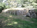
Remains of Numidian and then Roman town with well preserved temple and Arch as well as more ruins
You may be viewing yesterday's version of this page. To see the most up to date information please register for a free account.
")
")
Do not use the above information on other web sites or publications without permission of the contributor.
Nearby Images from Flickr
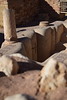
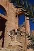
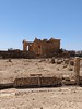
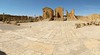
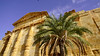
The above images may not be of the site on this page, but were taken nearby. They are loaded from Flickr so please click on them for image credits.
Click here to see more info for this site
Nearby sites
Click here to view sites on an interactive map of the areaKey: Red: member's photo, Blue: 3rd party photo, Yellow: other image, Green: no photo - please go there and take one, Grey: site destroyed
Download sites to:
KML (Google Earth)
GPX (GPS waypoints)
CSV (Garmin/Navman)
CSV (Excel)
To unlock full downloads you need to sign up as a Contributory Member. Otherwise downloads are limited to 50 sites.
Turn off the page maps and other distractions
Nearby sites listing. In the following links * = Image available
30.2km WSW 255° Celium Mausoleum Marker Stone
68.5km N 6° Mactaris Numidian Tomb* Chambered Tomb
68.6km N 7° Mactaris* Ancient Village or Settlement
69.0km N 7° Maktar Museum* Museum
75.0km NNW 338° Althiburos Ancient Village or Settlement
77.8km N 1° The Camel Stones* Standing Stone (Menhir)
78.4km N 359° Eles Megalithic Tomb 60* Burial Chamber or Dolmen
78.4km N 359° Eles Megalithic Tomb 25* Burial Chamber or Dolmen
78.5km N 359° Eles Megalithic Tomb 61* Burial Chamber or Dolmen
78.5km N 359° Eles Megalithic Tomb 24* Burial Chamber or Dolmen
78.5km N 359° Eles Megalithic Tomb 62* Burial Chamber or Dolmen
78.5km N 359° Eles Megalithic Tomb 23* Burial Chamber or Dolmen
78.5km N 359° Eles Megalithic Tomb 63* Burial Chamber or Dolmen
78.6km N 359° Eles Megalithic Tomb 22* Burial Chamber or Dolmen
78.7km N 359° Eles Megalithic Tomb 18* Burial Chamber or Dolmen
78.7km N 358° Eles Megalithic Tomb 28* Burial Chamber or Dolmen
78.7km N 359° Eles Megalithic Tomb 17* Burial Chamber or Dolmen
78.8km N 358° Eles Megalithic Tomb 29* Burial Chamber or Dolmen
78.8km N 359° Eles Megalithic Tomb 17B* Burial Chamber or Dolmen
78.8km N 359° Eles Megalithic Tomb 19* Burial Chamber or Dolmen
78.9km N 359° Eles Megalithic Tomb 14* Burial Chamber or Dolmen
78.9km N 359° Eles Megalithic Tomb 12 Burial Chamber or Dolmen
78.9km N 359° Eles Megalithic Tomb 15* Burial Chamber or Dolmen
78.9km N 359° Eles Megalithic tomb 16* Chambered Tomb
78.9km N 359° Eles Megalithic Tomb 11* Burial Chamber or Dolmen
View more nearby sites and additional images


 We would like to know more about this location. Please feel free to add a brief description and any relevant information in your own language.
 Wir möchten mehr über diese Stätte erfahren. Bitte zögern Sie nicht, eine kurze Beschreibung und relevante Informationen in Deutsch hinzuzufügen.
 Nous aimerions en savoir encore un peu sur les lieux. S'il vous plaît n'hesitez pas à ajouter une courte description et tous les renseignements pertinents dans votre propre langue.
 Quisieramos informarnos un poco más de las lugares. No dude en añadir una breve descripción y otros datos relevantes en su propio idioma.