

<< Our Photo Pages >> Frestedt Huegelgrab 3 - Round Barrow(s) in Germany in Schleswig-Holstein, Hamburg
Submitted by holger_rix on Tuesday, 23 October 2007 Page Views: 1480
Neolithic and Bronze AgeSite Name: Frestedt Huegelgrab 3Country: Germany
NOTE: This site is 6.762 km away from the location you searched for.
Land: Schleswig-Holstein, Hamburg Type: Round Barrow(s)
Nearest Village: Frestedt
Latitude: 54.010606N Longitude: 9.179531E
Condition:
| 5 | Perfect |
| 4 | Almost Perfect |
| 3 | Reasonable but with some damage |
| 2 | Ruined but still recognisable as an ancient site |
| 1 | Pretty much destroyed, possibly visible as crop marks |
| 0 | No data. |
| -1 | Completely destroyed |
| 5 | Superb |
| 4 | Good |
| 3 | Ordinary |
| 2 | Not Good |
| 1 | Awful |
| 0 | No data. |
| 5 | Can be driven to, probably with disabled access |
| 4 | Short walk on a footpath |
| 3 | Requiring a bit more of a walk |
| 2 | A long walk |
| 1 | In the middle of nowhere, a nightmare to find |
| 0 | No data. |
| 5 | co-ordinates taken by GPS or official recorded co-ordinates |
| 4 | co-ordinates scaled from a detailed map |
| 3 | co-ordinates scaled from a bad map |
| 2 | co-ordinates of the nearest village |
| 1 | co-ordinates of the nearest town |
| 0 | no data |
Internal Links:
External Links:
")
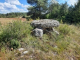
A Round Barrow near Frestedt....
You may be viewing yesterday's version of this page. To see the most up to date information please register for a free account.
Do not use the above information on other web sites or publications without permission of the contributor.
Nearby Images from Flickr
The above images may not be of the site on this page, but were taken nearby. They are loaded from Flickr so please click on them for image credits.
Click here to see more info for this site
Nearby sites
Click here to view sites on an interactive map of the areaKey: Red: member's photo, Blue: 3rd party photo, Yellow: other image, Green: no photo - please go there and take one, Grey: site destroyed
Download sites to:
KML (Google Earth)
GPX (GPS waypoints)
CSV (Garmin/Navman)
CSV (Excel)
To unlock full downloads you need to sign up as a Contributory Member. Otherwise downloads are limited to 50 sites.
Turn off the page maps and other distractions
Nearby sites listing. In the following links * = Image available
1.9km NE 41° Frestedt Huegelgrab 2* Round Barrow(s)
2.7km NNE 19° Frestedt Steingrab Burial Chamber or Dolmen
2.7km NNE 17° Frestedt Huegelgrab* Round Barrow(s)
3.2km SE 146° Buchholz Huegelgrab 1* Round Barrow(s)
3.3km SSW 210° St. Michaelisdonn Huegelgrab 1* Round Barrow(s)
3.3km S 188° Kuden Huegelgrab 2* Round Barrow(s)
3.4km SSW 203° Hopen Grabhuegelfeld* Round Barrow(s)
3.8km SSE 151° Kuden Huegelgrab 1* Round Barrow(s)
4.3km SSW 209° Hopen Huegelgrab* Round Barrow(s)
10.2km N 4° Dellbruecker Kammer* Burial Chamber or Dolmen
11.5km NE 52° Luetjenbornholt Grabhuegel* Round Barrow(s)
11.6km NE 42° Schafstedt Huegelgrab 3* Round Barrow(s)
11.6km NE 42° Schafstedt Huegelgrab 1* Round Barrow(s)
11.7km NNE 23° Tensbuettel Langbett* Long Barrow
11.8km NE 42° Schafstedt Huegelgrab 2* Round Barrow(s)
12.2km NNE 21° Tensbuettel Grabhuegel* Round Barrow(s)
13.5km NE 55° Oersdorfer Viert Huegelgrab* Round Barrow(s)
13.6km NNE 13° Harkestein* Natural Stone / Erratic / Other Natural Feature
13.8km E 90° Vaale Rugenbarg Steinkiste* Cist
13.8km E 91° Vaale Rugenbarg Grabhuegel 2* Round Barrow(s)
13.9km E 90° Vaale Rugenbarg Grabhuegel 3* Round Barrow(s)
14.4km NNE 26° Albersdorf Huegelgrab [1]* Round Barrow(s)
14.6km E 90° Vaale Rugenbarg Grabhuegel 4* Round Barrow(s)
14.6km E 90° Vaale Rugenbarg Grabhuegel 1* Round Barrow(s)
14.8km NNE 24° Schlaa Huegelgrab* Round Barrow(s)
View more nearby sites and additional images


 We would like to know more about this location. Please feel free to add a brief description and any relevant information in your own language.
 Wir möchten mehr über diese Stätte erfahren. Bitte zögern Sie nicht, eine kurze Beschreibung und relevante Informationen in Deutsch hinzuzufügen.
 Nous aimerions en savoir encore un peu sur les lieux. S'il vous plaît n'hesitez pas à ajouter une courte description et tous les renseignements pertinents dans votre propre langue.
 Quisieramos informarnos un poco más de las lugares. No dude en añadir una breve descripción y otros datos relevantes en su propio idioma.