

<< Our Photo Pages >> Complex Sunduki - Natural Stone / Erratic / Other Natural Feature in Russia
Submitted by AlexAssa on Thursday, 09 March 2017 Page Views: 1716
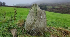
Natural PlacesSite Name: Complex Sunduki Alternative Name: СундукиCountry: Russia
NOTE: This site is 360.62 km away from the location you searched for.
Type: Natural Stone / Erratic / Other Natural Feature
Nearest Town: Abakan Nearest Village: Iyus
Latitude: 54.699674N Longitude: 89.746206E
Condition:
| 5 | Perfect |
| 4 | Almost Perfect |
| 3 | Reasonable but with some damage |
| 2 | Ruined but still recognisable as an ancient site |
| 1 | Pretty much destroyed, possibly visible as crop marks |
| 0 | No data. |
| -1 | Completely destroyed |
| 5 | Superb |
| 4 | Good |
| 3 | Ordinary |
| 2 | Not Good |
| 1 | Awful |
| 0 | No data. |
| 5 | Can be driven to, probably with disabled access |
| 4 | Short walk on a footpath |
| 3 | Requiring a bit more of a walk |
| 2 | A long walk |
| 1 | In the middle of nowhere, a nightmare to find |
| 0 | No data. |
| 5 | co-ordinates taken by GPS or official recorded co-ordinates |
| 4 | co-ordinates scaled from a detailed map |
| 3 | co-ordinates scaled from a bad map |
| 2 | co-ordinates of the nearest village |
| 1 | co-ordinates of the nearest town |
| 0 | no data |
Internal Links:
External Links:
")
The approximate age of use is about 18 thousand years..
More at megalithica.ru/
You may be viewing yesterday's version of this page. To see the most up to date information please register for a free account.
")
")
")
")
")
")
")
")
")
")
")
")
Do not use the above information on other web sites or publications without permission of the contributor.
Click here to see more info for this site
Nearby sites
Click here to view sites on an interactive map of the areaKey: Red: member's photo, Blue: 3rd party photo, Yellow: other image, Green: no photo - please go there and take one, Grey: site destroyed
Download sites to:
KML (Google Earth)
GPX (GPS waypoints)
CSV (Garmin/Navman)
CSV (Excel)
To unlock full downloads you need to sign up as a Contributory Member. Otherwise downloads are limited to 50 sites.
Turn off the page maps and other distractions
Nearby sites listing. In the following links * = Image available
34.9km SSE 159° Tuim Cromlech* Stone Circle
38.4km SSW 212° Paleolithic settlement Small Syya* Ancient Village or Settlement
111.7km SE 143° Great Salbyk Kurgan* Pyramid / Mastaba
155.1km SE 134° Museum Kyzlasov L.R.* Museum
241.2km NE 52° Settlement Afontova Mountain* Ancient Village or Settlement
245.3km NE 52° Krasnoyarsk Regional Museum of Local Lore* Museum
386.6km SSE 151° Ancient sanctuary Chaa-Holl* Rock Cut Tomb
390.9km SE 136° Arzhan Scythian royal necropolis* Barrow Cemetery
391.4km SW 222° Mayma VI Barrow Cemetery
395.8km SW 221° Anokhin Museum* Museum
399.2km SW 220° Oldest settlement Ulalinka* Ancient Village or Settlement
454.9km SE 135° Republican Museum of Kyzyl* Museum
471.8km SW 218° Tavdinsky Caves Cave or Rock Shelter
498.7km SW 226° Karama - Paleolithic settlement* Ancient Village or Settlement
499.4km SW 225° Denisova* Cave or Rock Shelter
501.7km SSW 213° Tuekta kurgan* Artificial Mound
515.0km SSW 203° Chuya Deer Stone* Standing Stone (Menhir)
517.3km SSW 204° Kalbak-Tash* Rock Art
519.1km SSW 205° Inya Deer Stones* Standing Stone (Menhir)
551.6km S 189° Tarhatinsky megalithic site* Standing Stones
629.8km S 190° Shiveet Mountain Petroglyphs* Rock Art
630.6km S 189° Mt. Shiveet altar stone with petroglyphs* Rock Art
638.8km SSW 203° Berel Burial Mounds* Barrow Cemetery
680.1km S 189° Lake Hoton Petroglyphs* Rock Art
680.6km S 188° Lake Hoton Round Barrow Round Barrow(s)
View more nearby sites and additional images


 We would like to know more about this location. Please feel free to add a brief description and any relevant information in your own language.
 Wir möchten mehr über diese Stätte erfahren. Bitte zögern Sie nicht, eine kurze Beschreibung und relevante Informationen in Deutsch hinzuzufügen.
 Nous aimerions en savoir encore un peu sur les lieux. S'il vous plaît n'hesitez pas à ajouter une courte description et tous les renseignements pertinents dans votre propre langue.
 Quisieramos informarnos un poco más de las lugares. No dude en añadir una breve descripción y otros datos relevantes en su propio idioma.