<< Our Photo Pages >> Syauli stone - Natural Stone / Erratic / Other Natural Feature in Nepal
Submitted by pab on Monday, 12 March 2012 Page Views: 5610
Natural PlacesSite Name: Syauli stoneCountry: Nepal
NOTE: This site is 86.304 km away from the location you searched for.
Type: Natural Stone / Erratic / Other Natural Feature
Nearest Village: Ghandruk
Latitude: 28.355278N Longitude: 83.804703E
Condition:
| 5 | Perfect |
| 4 | Almost Perfect |
| 3 | Reasonable but with some damage |
| 2 | Ruined but still recognisable as an ancient site |
| 1 | Pretty much destroyed, possibly visible as crop marks |
| 0 | No data. |
| -1 | Completely destroyed |
| 5 | Superb |
| 4 | Good |
| 3 | Ordinary |
| 2 | Not Good |
| 1 | Awful |
| 0 | No data. |
| 5 | Can be driven to, probably with disabled access |
| 4 | Short walk on a footpath |
| 3 | Requiring a bit more of a walk |
| 2 | A long walk |
| 1 | In the middle of nowhere, a nightmare to find |
| 0 | No data. |
| 5 | co-ordinates taken by GPS or official recorded co-ordinates |
| 4 | co-ordinates scaled from a detailed map |
| 3 | co-ordinates scaled from a bad map |
| 2 | co-ordinates of the nearest village |
| 1 | co-ordinates of the nearest town |
| 0 | no data |
Internal Links:
External Links:
I have visited· I would like to visit
PAB has visited here
")
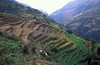
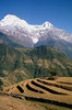
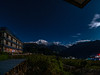
This stone was on the 10,000-step stretch up to Ghandruk - with the glorious view up to the peak of Machapuchare (Fish tail) always ahead to help encourage us to keep going!
Posted today as memorial to those who suffered in Japan a year ago - we were woken that night by 3 'shudders' in the lodge we were staying in, not realising until the next morning that a major quake had happened further along whatever fault line runs from Japan to Nepal....
You may be viewing yesterday's version of this page. To see the most up to date information please register for a free account.
Do not use the above information on other web sites or publications without permission of the contributor.
Nearby Images from Flickr

The above images may not be of the site on this page, but were taken nearby. They are loaded from Flickr so please click on them for image credits.
Click here to see more info for this site
Nearby sites
Click here to view sites on an interactive map of the areaKey: Red: member's photo, Blue: 3rd party photo, Yellow: other image, Green: no photo - please go there and take one, Grey: site destroyed
Download sites to:
KML (Google Earth)
GPX (GPS waypoints)
CSV (Garmin/Navman)
CSV (Excel)
To unlock full downloads you need to sign up as a Contributory Member. Otherwise downloads are limited to 50 sites.
Turn off the page maps and other distractions
Nearby sites listing. In the following links * = Image available
151.7km ESE 114° Pang-2 Cave or Rock Shelter
184.3km SSW 194° Bansdeela-Teelatar Ancient Village or Settlement
192.0km ESE 115° New Nepal Megalith (Dhulikhel)* Standing Stone (Menhir)
305.9km ESE 114° Haleshi Mahadeva Cave or Rock Shelter
373.9km SSE 158° Telhara Ancient Temple
392.9km SSE 161° Barabar Caves* Cave or Rock Shelter
393.2km SSE 155° Nalanda University excavated site* Ancient Temple
397.6km WSW 238° Jajmau ka tila Ancient Village or Settlement
422.4km WNW 291° Lakhudiyar Rock Art Rock Art
439.1km S 191° Obra standing stones Standing Stones
511.5km SSE 161° Rola.* Standing Stones
516.0km SSE 156° Dhekia Pathar* Burial Chamber or Dolmen
518.8km SSE 164° Punkri Burwadih* Chambered Tomb
554.5km E 99° Taktsang Monastery, Bhutan* Ancient Temple
556.8km E 99° Kyichu Lhakhang Ancient Temple
561.9km E 99° The National Museum of Bhutan* Museum
568.6km E 82° Palcho Monastery* Ancient Temple
614.6km SSE 159° Chokahatu* Barrow Cemetery
647.4km W 273° Qutab Minar Complex* Ancient Temple
667.2km ESE 123° Mahasthangarh Ancient Village or Settlement
674.3km SSE 162° Chaibasa Standing Stones
676.9km WNW 303° Shri Bhima Kali Temple at Sarahan* Ancient Temple
685.8km W 278° Farmana Harappan burial site Ancient Village or Settlement
686.3km E 96° Dorje Dolmen Thamshing* Burial Chamber or Dolmen
686.7km E 96° Bumthang cup-marked Stone Rock Art
View more nearby sites and additional images


 We would like to know more about this location. Please feel free to add a brief description and any relevant information in your own language.
 Wir möchten mehr über diese Stätte erfahren. Bitte zögern Sie nicht, eine kurze Beschreibung und relevante Informationen in Deutsch hinzuzufügen.
 Nous aimerions en savoir encore un peu sur les lieux. S'il vous plaît n'hesitez pas à ajouter une courte description et tous les renseignements pertinents dans votre propre langue.
 Quisieramos informarnos un poco más de las lugares. No dude en añadir una breve descripción y otros datos relevantes en su propio idioma.