

<< Other Photo Pages >> Eresburg - Hillfort in Germany in North Rhine-Westphalia
Submitted by Harald_Platta on Thursday, 17 September 2015 Page Views: 3350
Multi-periodSite Name: EresburgCountry: Germany
NOTE: This site is 8.881 km away from the location you searched for.
Land: North Rhine-Westphalia Type: Hillfort
Nearest Town: Marsberg Nearest Village: Obermarsberg
Latitude: 51.450280N Longitude: 8.852780E
Condition:
| 5 | Perfect |
| 4 | Almost Perfect |
| 3 | Reasonable but with some damage |
| 2 | Ruined but still recognisable as an ancient site |
| 1 | Pretty much destroyed, possibly visible as crop marks |
| 0 | No data. |
| -1 | Completely destroyed |
| 5 | Superb |
| 4 | Good |
| 3 | Ordinary |
| 2 | Not Good |
| 1 | Awful |
| 0 | No data. |
| 5 | Can be driven to, probably with disabled access |
| 4 | Short walk on a footpath |
| 3 | Requiring a bit more of a walk |
| 2 | A long walk |
| 1 | In the middle of nowhere, a nightmare to find |
| 0 | No data. |
| 5 | co-ordinates taken by GPS or official recorded co-ordinates |
| 4 | co-ordinates scaled from a detailed map |
| 3 | co-ordinates scaled from a bad map |
| 2 | co-ordinates of the nearest village |
| 1 | co-ordinates of the nearest town |
| 0 | no data |
Internal Links:
External Links:
")
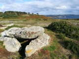
Eresberg hill was the place of a Neolithic settlement, as shown by pieces of pottery from the Michelsberg culture.
The oldest parts of the hillfort were discovered at the presentday collegiate church St. Petrus & Paulus, where the remains of ditches, ramparts and posts are preserved. Radio carbon dating of the wooden posts dates the hillfort to the Pre-Roman Iron Age (420 and 370 BC).
The hillfort was also used in the Germanic Iron Age. It is assumed that it served as a border castle of the Cherusci tribe. Moreover, it has been speculated, that the Cherusci leader Segestes might have held his daughter Thusnelda as prisoner here, because she had become the wife of his rival, Arminius (Hermann). However, there is no evidence available that could support this theory. Finally, the Cherusci became a part of the Saxon community.
The Eresburg was conquered by the Frankish king Karl der Große (Charles the Great, Charlemagne) in 772 AD. He stayed several months at the Eresburg and initiated the construction of the first version of today`s St. Petrus & Paulus church, making it one of the oldest churches in Westphalia. Most likely, the church was built on the site of the former Saxon sanctuary. The destruction of the Irminsul within this sanctuary was regarded as a deeply symbolic act during his war against the pagan Saxons. Later, Pope Leo III is supposed to have stayed at the Eresburg in 799 on his way to Paderborn.
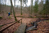
Because of its strategic position, the Eresberg hill became the place of several acts of war during the following centuries. It remained a strong fortification from the middle ages to the early modern era. Parts of this medieval wall and two of the formerly seven towers can still be seen today.
Several archaeological finds from prehistory to modern times are displayed in the Heimatmuseum Stadt Marsberg. A modern stone replica (from the 1930`s) of the Irminsul can be seen in the crypta of St. Petrus & Paulus church.
Literature:
[01] Bérenger, D.: Die eisenzeitliche Höhenbefestigung von Obermarsberg. In: Archäologie in Ostwestfalen 6. Verlag für Regionalgeschichte, Bielefeld (2002).
[02] Cichy, E.: Die Eresburg, Marsberg-Obermarsberg, Hochsauerlandkreis. In: Frühe Burgen in Westfalen 36 (2013).
[03] Cichy, E.: Eresburg - Eine Grabung, viele Fragen. In: Westfalen in der Eisenzeit (2015).
You may be viewing yesterday's version of this page. To see the most up to date information please register for a free account.
Do not use the above information on other web sites or publications without permission of the contributor.
Nearby Images from Flickr


The above images may not be of the site on this page, but were taken nearby. They are loaded from Flickr so please click on them for image credits.
Click here to see more info for this site
Nearby sites
Click here to view sites on an interactive map of the areaKey: Red: member's photo, Blue: 3rd party photo, Yellow: other image, Green: no photo - please go there and take one, Grey: site destroyed
Download sites to:
KML (Google Earth)
GPX (GPS waypoints)
CSV (Garmin/Navman)
CSV (Excel)
To unlock full downloads you need to sign up as a Contributory Member. Otherwise downloads are limited to 50 sites.
Turn off the page maps and other distractions
Nearby sites listing. In the following links * = Image available
403m NNW 335° Drakenhöhlen* Cave or Rock Shelter
10.6km W 270° Madfeld Iron Age Settlement and Forge Ancient Village or Settlement
13.4km SE 126° Summstein Arolsen Modern Stone Circle etc
13.4km WSW 250° Hollenloch* Cave or Rock Shelter
13.8km NW 305° Wünnenberg Galeriegrab Chambered Tomb
16.0km NE 54° Kellberg Huegelgraeber (1)* Cairn
16.2km NE 37° Opferstein Hardehausen Natural Stone / Erratic / Other Natural Feature
16.3km N 350° Atteln 1* Chambered Tomb
16.9km N 349° Atteln Galeriegrab (2)* Burial Chamber or Dolmen
17.3km ENE 56° Weisses Holz Huegelgrab (1)* Cairn
17.3km ENE 57° Rimbeck* Passage Grave
17.4km ENE 57° Erdwerk von Rimbeck* Misc. Earthwork
17.9km NNW 340° Henglarn Steinkammergrab (2)* Chambered Tomb
18.5km NNW 340° Henglarn Galeriegrab 1* Chambered Tomb
18.7km NNE 22° Grabhügelfeld Bühlheimer Heide Barrow Cemetery
19.4km NNE 31° Kleiner Herrgott* Ancient Cross
19.6km WSW 246° Summstein Hängeberg Modern Stone Circle etc
19.8km ENE 75° Warburg Galeriegrab (3)* Chambered Tomb
19.9km ENE 74° Warburg Galeriegrab (1)* Chambered Tomb
19.9km NW 318° Wewelsburg Galeriegrab 2 Chambered Tomb
19.9km NNE 32° Behmburg* Hillfort
20.0km ENE 75° Warburg Galeriegrab (5) Chambered Tomb
20.0km ENE 75° Warburg Galeriegrab (4)* Chambered Tomb
20.0km ENE 74° Warburg Galeriegrab (2) Chambered Tomb
20.2km NNE 33° Opferstein am Hexenberg* Natural Stone / Erratic / Other Natural Feature
View more nearby sites and additional images


 We would like to know more about this location. Please feel free to add a brief description and any relevant information in your own language.
 Wir möchten mehr über diese Stätte erfahren. Bitte zögern Sie nicht, eine kurze Beschreibung und relevante Informationen in Deutsch hinzuzufügen.
 Nous aimerions en savoir encore un peu sur les lieux. S'il vous plaît n'hesitez pas à ajouter une courte description et tous les renseignements pertinents dans votre propre langue.
 Quisieramos informarnos un poco más de las lugares. No dude en añadir una breve descripción y otros datos relevantes en su propio idioma.