

<< Our Photo Pages >> Dømmesmoen - Barrow Cemetery in Norway in Aust-Agder
Submitted by kenntha88 on Thursday, 21 August 2014 Page Views: 1696
Neolithic and Bronze AgeSite Name: DømmesmoenCountry: Norway
NOTE: This site is 3.037 km away from the location you searched for.
Fylke: Aust-Agder Type: Barrow Cemetery
Nearest Town: Grimstad
Latitude: 58.355439N Longitude: 8.576556E
Condition:
| 5 | Perfect |
| 4 | Almost Perfect |
| 3 | Reasonable but with some damage |
| 2 | Ruined but still recognisable as an ancient site |
| 1 | Pretty much destroyed, possibly visible as crop marks |
| 0 | No data. |
| -1 | Completely destroyed |
| 5 | Superb |
| 4 | Good |
| 3 | Ordinary |
| 2 | Not Good |
| 1 | Awful |
| 0 | No data. |
| 5 | Can be driven to, probably with disabled access |
| 4 | Short walk on a footpath |
| 3 | Requiring a bit more of a walk |
| 2 | A long walk |
| 1 | In the middle of nowhere, a nightmare to find |
| 0 | No data. |
| 5 | co-ordinates taken by GPS or official recorded co-ordinates |
| 4 | co-ordinates scaled from a detailed map |
| 3 | co-ordinates scaled from a bad map |
| 2 | co-ordinates of the nearest village |
| 1 | co-ordinates of the nearest town |
| 0 | no data |
Internal Links:
External Links:
I have visited· I would like to visit
Martin_L has visited here
")
This large barrow cemetery consits of 43 round barrows, one three-pointed stone setting with one stone in each of the three corners and two in the middle, two smaller stone circles where the stones have toppled over, and I counted at least 10 single standing stones. In total there are around 60 burials.
The single standing stones are as follow (as I walked trough the cemetery), the first is around 1 metre high and around 30X30cm wide. It is standing on the top of a round barrow. The second is around 40cm high and around 20X30cm wide. The third is around 1,5 metre in height and around 20X30 wide at the base, it ends in a point. The fourth is around 1,6 metres high, around 1,55 metres wide and arond 20cm thick. It looks like a standing slab. It is oriented on a line with the two stones in the centre of the triangular stone setting and the North East corner stone. A small stone (the fifth stone) is standing 2 metres away from number four, it is unclear however if these two stones are a part of the same burial monument. The smaller stone is around 40cm high and around 20X20cm wide. The sixth stone is around 60cm high, around 30cm wide and around 10cm thick. It has a rounded top. The seventh and eight stones are standing just 2 metres away, making it probable they were once a part of the same burial. They are both around 40-50cm in height and around 20cm wide. The last stone is around 1,5 metres in height, around 80cm wide and around 50cm thick. It has a oval or rounded cross section and is standing at the edge of the cemetery.
Some of the smaller standing stones are described in earlyer documents as beeing parts of stone circle burial monuments where most of the other stones have been removed or fallen over, beeing covered in earth and grass. There is very difficult to destinguish which stones might have been belonging to these previously described stone circles.
Of the 43 barrows, two of them are elongated long barrows while the rest of the round barrows are round in shape. They vary in size from around 12 metres in diameter to around 4 metres. And from around 0,5 metres in height to around 1,5 metres. Some of the barrow have clear ditches around the edges and some of them have very pretty rounded tops. Some of the barrow have been restored in later years, but some of the barrows have been damaged in later years and some have been flattened.
The most noticable burial monument in the cemetery is the triangular stone setting. Each of the distance between the stones are equal, making it a triangle with each side 14 metres long. The corner stones are around 1,2 to 1,5 metres in height, around 60-70cm wide and around 20-30 thick. They have rounded tops. The two center stones are around 1,6 metres in height, sligthly taller than the cornerstones. They are around 80-70cm wide and around 30cm thick. They appear almost similar in size and the distance between them are only around 30-40cm. The triangular setting is very similar to the site "the five foolish virgins" at Karmøy Rogaland. The setting was excavated in 1950. It was found pieces of ceramics, a bronze plate, a needle and some burned bones.
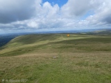
The site is very easy to observe, there are signposts, a parking lot nearby and small footpaths leads trough the site. It is almost only short cut grass and some large trees spread around the site.
You may be viewing yesterday's version of this page. To see the most up to date information please register for a free account.
")
")
")
")
")
")
")
")
")
")
")
")
")
")
")
")
")
")
")
")
")
")
")
")
These are just the first 25 photos of Dømmesmoen. If you log in with a free user account you will be able to see our entire collection.
Do not use the above information on other web sites or publications without permission of the contributor.
Click here to see more info for this site
Nearby sites
Click here to view sites on an interactive map of the areaKey: Red: member's photo, Blue: 3rd party photo, Yellow: other image, Green: no photo - please go there and take one, Grey: site destroyed
Download sites to:
KML (Google Earth)
GPX (GPS waypoints)
CSV (Garmin/Navman)
CSV (Excel)
To unlock full downloads you need to sign up as a Contributory Member. Otherwise downloads are limited to 50 sites.
Turn off the page maps and other distractions
Nearby sites listing. In the following links * = Image available
1.7km NE 45° Fjære* Barrow Cemetery
1.8km SE 142° Bringsvær Hellekistegraver* Cist
3.1km ENE 61° Vik (Grimstad)* Stone Circle
3.2km NE 51° Bringsvær* Barrow Cemetery
3.5km ENE 65° Fevikveien stone circle* Stone Circle
5.0km E 89° Ytre Grevstad* Stone Circle
6.5km ENE 64° Øvre Fevik* Barrow Cemetery
6.8km ENE 64° Fevikmoen* Barrow Cemetery
8.6km ENE 70° Kvennbekkrøysa* Cairn
17.1km ENE 59° Hoveodden Røyser* Cairn
17.7km ENE 59° Hovestien* Cairn
18.0km N 10° Mjølhusmoen* Barrow Cemetery
18.1km ENE 59° Hove Leir gravhauger* Barrow Cemetery
20.2km WSW 254° Skillsteinene* Stone Row / Alignment
22.9km W 260° The Mollestad Oak* Natural Stone / Erratic / Other Natural Feature
32.7km NNE 31° Vestre Godderstad* Stone Circle
34.0km WSW 238° Hamresanden Tingringen* Stone Circle
34.5km WSW 238° Hamresanden Ancient Village or Settlement
39.5km WSW 237° Oddernes Runestone* Carving
39.5km WSW 238° Pjolterhaugen* Round Barrow(s)
49.1km WSW 256° Stallemo* Barrow Cemetery
51.4km WSW 238° Tingsteinen* Ring Cairn
52.2km SW 236° Tangvall cist* Cist
52.2km SW 236° Søgne Runestone* Carving
52.3km WNW 299° Galteland Runestone and Verksmoen Barrow Cemetery* Carving
View more nearby sites and additional images


 We would like to know more about this location. Please feel free to add a brief description and any relevant information in your own language.
 Wir möchten mehr über diese Stätte erfahren. Bitte zögern Sie nicht, eine kurze Beschreibung und relevante Informationen in Deutsch hinzuzufügen.
 Nous aimerions en savoir encore un peu sur les lieux. S'il vous plaît n'hesitez pas à ajouter une courte description et tous les renseignements pertinents dans votre propre langue.
 Quisieramos informarnos un poco más de las lugares. No dude en añadir una breve descripción y otros datos relevantes en su propio idioma.