


<< Text Pages >> Summstein Bonndorf - Modern Stone Circle etc in Germany in Baden-Wuerttemberg
Submitted by Harald_Platta on Sunday, 03 December 2017 Page Views: 627
Modern SitesSite Name: Summstein BonndorfCountry: Germany Land: Baden-Wuerttemberg Type: Modern Stone Circle etc
Nearest Town: Bonndorf
Latitude: 47.816000N Longitude: 8.341600E
Condition:
| 5 | Perfect |
| 4 | Almost Perfect |
| 3 | Reasonable but with some damage |
| 2 | Ruined but still recognisable as an ancient site |
| 1 | Pretty much destroyed, possibly visible as crop marks |
| 0 | No data. |
| -1 | Completely destroyed |
| 5 | Superb |
| 4 | Good |
| 3 | Ordinary |
| 2 | Not Good |
| 1 | Awful |
| 0 | No data. |
| 5 | Can be driven to, probably with disabled access |
| 4 | Short walk on a footpath |
| 3 | Requiring a bit more of a walk |
| 2 | A long walk |
| 1 | In the middle of nowhere, a nightmare to find |
| 0 | No data. |
| 5 | co-ordinates taken by GPS or official recorded co-ordinates |
| 4 | co-ordinates scaled from a detailed map |
| 3 | co-ordinates scaled from a bad map |
| 2 | co-ordinates of the nearest village |
| 1 | co-ordinates of the nearest town |
| 0 | no data |
Be the first person to rate this site - see the 'Contribute!' box in the right hand menu.
Internal Links:
External Links:
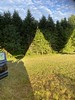
The Summstein ("Humming Stone") is a modern stone sculpture situated in Bonndorf (Baden-Wuerttemberg/Germany).
Further information and literature on Summsteine in general: MP page Großer Summstein.
Reference:
[01] Waymarking.com: Summstein 'Japanischer Garten' - Bonndorf, Germany, BW.
You may be viewing yesterday's version of this page. To see the most up to date information please register for a free account.
Do not use the above information on other web sites or publications without permission of the contributor.
Nearby Images from Flickr

The above images may not be of the site on this page, but were taken nearby. They are loaded from Flickr so please click on them for image credits.
Click here to see more info for this site
Nearby sites
Click here to view sites on an interactive map of the areaKey: Red: member's photo, Blue: 3rd party photo, Yellow: other image, Green: no photo - please go there and take one, Grey: site destroyed
Download sites to:
KML (Google Earth)
GPX (GPS waypoints)
CSV (Garmin/Navman)
CSV (Excel)
To unlock full downloads you need to sign up as a Contributory Member. Otherwise downloads are limited to 50 sites.
Turn off the page maps and other distractions
Nearby sites listing. In the following links * = Image available
11.8km NNE 22° Guldenen Grabhügelgruppe Barrow Cemetery
12.2km W 263° Schluchsee Steinkreise Stone Circle
17.2km SSE 167° Steinkiste Degernau* Chambered Tomb
17.5km SSE 165° Degernau Menhir* Standing Stone (Menhir)
17.7km SSW 213° Langstein - Weilheim* Standing Stone (Menhir)
19.2km E 86° Blauer Stein Natural Stone / Erratic / Other Natural Feature
21.5km SSW 193° Langenstein - Tiengen* Standing Stone (Menhir)
21.9km NE 41° Oberer Schiessbühl Grabhügelgruppe Barrow Cemetery
21.9km NE 42° Unterer Schiessbühl Grabhügelgruppe Barrow Cemetery
22.2km NE 46° Buckhäule Grabhügelgruppe Barrow Cemetery
23.2km NNE 14° Eggwald Grabhügelgruppe Barrow Cemetery
23.6km SSW 204° Waldshut Heimatmuseum Museum
24.5km ESE 115° Abri Schweizersbild* Cave or Rock Shelter
26.5km NNE 17° Magdalenenbergle* Round Barrow(s)
27.4km ESE 106° Kesslerloch* Cave or Rock Shelter
27.5km SE 131° Altenburg Keltisches Oppidum Museum
28.4km NNE 18° Franziskanermuseum Museum
30.0km NNE 28° Schwenningen Grabhügelgruppe Barrow Cemetery
30.4km E 90° Ertenhag Grabhügelgruppe Barrow Cemetery
30.8km WNW 302° Tarodonum Keltische Oppidum Hillfort
33.7km NE 46° Zeugenberg Vorgeschichtlich Siedlung Ancient Village or Settlement
35.1km E 82° Petersfels* Rock Outcrop
35.1km NNE 14° Judenbühl Grabhügel Round Barrow(s)
36.2km E 79° Ziegelhau Grabhügelgruppe Barrow Cemetery
36.3km NNE 27° Kehlwald Grabhügelgruppe Barrow Cemetery
View more nearby sites and additional images


 We would like to know more about this location. Please feel free to add a brief description and any relevant information in your own language.
 Wir möchten mehr über diese Stätte erfahren. Bitte zögern Sie nicht, eine kurze Beschreibung und relevante Informationen in Deutsch hinzuzufügen.
 Nous aimerions en savoir encore un peu sur les lieux. S'il vous plaît n'hesitez pas à ajouter une courte description et tous les renseignements pertinents dans votre propre langue.
 Quisieramos informarnos un poco más de las lugares. No dude en añadir una breve descripción y otros datos relevantes en su propio idioma.