<< Other Photo Pages >> Jirzankal cemetery - Barrow Cemetery in China
Submitted by Andy B on Sunday, 10 November 2019 Page Views: 2080
Neolithic and Bronze AgeSite Name: Jirzankal cemeteryCountry: China Type: Barrow Cemetery
Nearest Town: Tashkurgan City
Latitude: 37.848333N Longitude: 75.203056E
Condition:
| 5 | Perfect |
| 4 | Almost Perfect |
| 3 | Reasonable but with some damage |
| 2 | Ruined but still recognisable as an ancient site |
| 1 | Pretty much destroyed, possibly visible as crop marks |
| 0 | No data. |
| -1 | Completely destroyed |
| 5 | Superb |
| 4 | Good |
| 3 | Ordinary |
| 2 | Not Good |
| 1 | Awful |
| 0 | No data. |
| 5 | Can be driven to, probably with disabled access |
| 4 | Short walk on a footpath |
| 3 | Requiring a bit more of a walk |
| 2 | A long walk |
| 1 | In the middle of nowhere, a nightmare to find |
| 0 | No data. |
| 5 | co-ordinates taken by GPS or official recorded co-ordinates |
| 4 | co-ordinates scaled from a detailed map |
| 3 | co-ordinates scaled from a bad map |
| 2 | co-ordinates of the nearest village |
| 1 | co-ordinates of the nearest town |
| 0 | no data |
Be the first person to rate this site - see the 'Contribute!' box in the right hand menu.
Internal Links:
External Links:
")
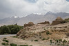
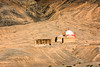
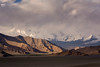
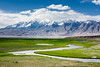
The region, 3050 meters above sea level, has a typical alpine climate with long winters and brief summers. The cemetery is approximately 10 km away from Tashkurgan City to the south and 180 km away from Kashgar, the capital of the prefecture where the cemetery is situated.
During the two excavation seasons, at least 39 individual human corpses and two hundred mortuary goods were revealed. The mortuary goods included abundant pottery items, stone tools, wooden items, textiles, sporadic copper objects and ironware. AMS radiocarbon dating of various samples from nine graves, including Five bones, six wood/charcoal fragments and one textile sample jointly assign the cemetery to ca. 2500 yr BP, corre-
sponding to the early Iron Age.
In 2016, bone samples from 12 ovicaprids (goat/sheep) and enamel samples from 34 individuals were analyzed for strontium isotope ratios.
Source: Wang, X. et al. Strontium isotope evidence for a highly mobile population on the Pamir Plateau 2500 years ago. Sci. Rep. 6, 35162; doi: 10.1038/srep35162 (2016).
You may be viewing yesterday's version of this page. To see the most up to date information please register for a free account.
")
")
")
")
Do not use the above information on other web sites or publications without permission of the contributor.
Nearby Images from Flickr

The above images may not be of the site on this page, but were taken nearby. They are loaded from Flickr so please click on them for image credits.
Click here to see more info for this site
Nearby sites
Click here to view sites on an interactive map of the areaKey: Red: member's photo, Blue: 3rd party photo, Yellow: other image, Green: no photo - please go there and take one, Grey: site destroyed
Download sites to:
KML (Google Earth)
GPX (GPS waypoints)
CSV (Garmin/Navman)
CSV (Excel)
To unlock full downloads you need to sign up as a Contributory Member. Otherwise downloads are limited to 50 sites.
Turn off the page maps and other distractions
Nearby sites listing. In the following links * = Image available
8.6km SSE 167° Tashkurgan* Ancient Village or Settlement
177.3km SSW 196° Hunza Valley Petroglyphs* Rock Art
216.9km NNE 24° Mor Stupas* Ancient Temple
231.1km SSW 202° Kargah Buddha* Rock Art
376.2km NW 323° The Heavenly Horses Rock Art
377.5km SW 235° Chitral Graves Ancient Village or Settlement
389.1km NNW 343° Saimaly-Tash Rock Art
399.7km SSE 164° Mulbekh Maitreya rock sculpture Sculptured Stone
400.4km SSE 148° Panamik Petroglyphs* Rock Art
408.1km SSE 159° Dhomkar Rock Art* Rock Art
410.2km S 184° Burzahom Archaeological Site Standing Stones
415.4km SSE 150° Hundar Buddha sculptured stone* Rock Art
417.0km SSE 159° Khalsi Petroglyphs Rock Art
423.5km SSE 149° Diskit petroglyphs* Rock Art
424.8km SSE 157° Nurla Petroglyphs Rock Art
426.2km SSE 151° Camouflage Shield Stone* Rock Art
427.3km SSE 156° Hemis Shukpachan cup marked stone* Rock Art
427.3km SSE 156° Hemis Shukpachen Palace* Ancient Palace
427.4km SSE 156° Hemis Shukpachan engraved stone* Rock Art
427.4km SSE 156° Hemis Shukpachan Menhir* Standing Stone (Menhir)
432.8km E 100° Dandan Oilik* Ancient Village or Settlement
437.7km SSE 156° Alchi petroglyphs* Rock Art
437.9km SW 218° Ghalegay Caves Cave or Rock Shelter
437.9km SW 218° Swat Buddha Sculptured Stone
439.5km SW 218° Shingardar Stupa Ancient Temple
View more nearby sites and additional images


 We would like to know more about this location. Please feel free to add a brief description and any relevant information in your own language.
 Wir möchten mehr über diese Stätte erfahren. Bitte zögern Sie nicht, eine kurze Beschreibung und relevante Informationen in Deutsch hinzuzufügen.
 Nous aimerions en savoir encore un peu sur les lieux. S'il vous plaît n'hesitez pas à ajouter une courte description et tous les renseignements pertinents dans votre propre langue.
 Quisieramos informarnos un poco más de las lugares. No dude en añadir una breve descripción y otros datos relevantes en su propio idioma.