<< Our Photo Pages >> Tamgaly Petroglyphs - Rock Art in Kazakhstan
Submitted by Jansold on Thursday, 23 May 2013 Page Views: 5784
Rock ArtSite Name: Tamgaly Petroglyphs Alternative Name: Tamgaly TasCountry: Kazakhstan
NOTE: This site is 292.399 km away from the location you searched for.
Type: Rock Art
Nearest Town: Almaty
Latitude: 43.803333N Longitude: 75.535000E
Condition:
| 5 | Perfect |
| 4 | Almost Perfect |
| 3 | Reasonable but with some damage |
| 2 | Ruined but still recognisable as an ancient site |
| 1 | Pretty much destroyed, possibly visible as crop marks |
| 0 | No data. |
| -1 | Completely destroyed |
| 5 | Superb |
| 4 | Good |
| 3 | Ordinary |
| 2 | Not Good |
| 1 | Awful |
| 0 | No data. |
| 5 | Can be driven to, probably with disabled access |
| 4 | Short walk on a footpath |
| 3 | Requiring a bit more of a walk |
| 2 | A long walk |
| 1 | In the middle of nowhere, a nightmare to find |
| 0 | No data. |
| 5 | co-ordinates taken by GPS or official recorded co-ordinates |
| 4 | co-ordinates scaled from a detailed map |
| 3 | co-ordinates scaled from a bad map |
| 2 | co-ordinates of the nearest village |
| 1 | co-ordinates of the nearest town |
| 0 | no data |
Internal Links:
External Links:
I have visited· I would like to visit
Jansold visited on 22nd May 2004 - their rating: Cond: 4 Amb: 4 Access: 4
")
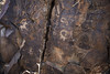
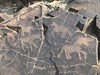
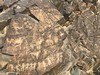
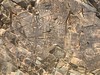
The glyphs have been etched into the smooth rock faces with stone or metal tools and consist mainly of various deities, zoomorphic beings and animals.
You may be viewing yesterday's version of this page. To see the most up to date information please register for a free account.
")
")
")
Do not use the above information on other web sites or publications without permission of the contributor.
Nearby Images from Flickr

The above images may not be of the site on this page, but were taken nearby. They are loaded from Flickr so please click on them for image credits.
Click here to see more info for this site
Nearby sites
Click here to view sites on an interactive map of the areaKey: Red: member's photo, Blue: 3rd party photo, Yellow: other image, Green: no photo - please go there and take one, Grey: site destroyed
Download sites to:
KML (Google Earth)
GPX (GPS waypoints)
CSV (Garmin/Navman)
CSV (Excel)
To unlock full downloads you need to sign up as a Contributory Member. Otherwise downloads are limited to 50 sites.
Turn off the page maps and other distractions
Nearby sites listing. In the following links * = Image available
55.8km SSE 164° Targan Barrow Cemetery Barrow Cemetery
119.6km S 191° Balasagun stone Balbas Sculptured Stone
127.6km SW 217° State Historical Museum of Kyrgyz Republic, Bishkek* Museum
130.4km ESE 118° The Central State Museum of the Republic of Kazakhstan* Museum
214.7km E 86° Complex Besshatyr* Artificial Mound
222.9km S 183° East Song Köl Balbal* Sculptured Stone
274.0km ESE 121° Karakol Regional Museum* Museum
274.3km ESE 121° Karakol Park* Sculptured Stone
324.1km SSW 206° Saimaly-Tash Rock Art
442.6km SW 215° The Heavenly Horses Rock Art
468.9km S 172° Mor Stupas* Ancient Temple
611.2km ESE 109° Kizil Caves of 1000 Buddhas* Cave or Rock Shelter
645.9km NE 50° Eleke Sazy Burial Mounds* Barrow Cemetery
662.8km S 183° Jirzankal cemetery* Barrow Cemetery
671.1km S 182° Tashkurgan* Ancient Village or Settlement
789.9km SE 136° Karadong* Ancient Village or Settlement
793.5km ENE 59° Shilikty Burial Mounds Barrow Cemetery
822.9km WSW 237° Sarazm Ancient Village or Settlement
835.9km S 185° Hunza Valley Petroglyphs* Rock Art
836.0km SSE 152° Dandan Oilik* Ancient Village or Settlement
846.0km NNE 31° Seleutas Mountain Sphinx* Natural Stone / Erratic / Other Natural Feature
864.4km SE 146° Rawak* Ancient Village or Settlement
884.3km S 187° Kargah Buddha* Rock Art
900.9km SW 217° Ai-Khanoum Ancient Village or Settlement
903.5km SW 228° Dalverzin Tepe Ancient Village or Settlement
View more nearby sites and additional images


 We would like to know more about this location. Please feel free to add a brief description and any relevant information in your own language.
 Wir möchten mehr über diese Stätte erfahren. Bitte zögern Sie nicht, eine kurze Beschreibung und relevante Informationen in Deutsch hinzuzufügen.
 Nous aimerions en savoir encore un peu sur les lieux. S'il vous plaît n'hesitez pas à ajouter une courte description et tous les renseignements pertinents dans votre propre langue.
 Quisieramos informarnos un poco más de las lugares. No dude en añadir una breve descripción y otros datos relevantes en su propio idioma.