

<< Text Pages >> Grottes dites Trou de Sainte-Reine - Cave or Rock Shelter in France in Alsace-Lorraine:Meurthe-et-Moselle
Submitted by holger_rix on Thursday, 28 April 2016 Page Views: 1067
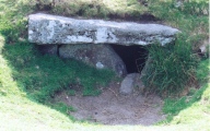
Natural PlacesSite Name: Grottes dites Trou de Sainte-Reine Alternative Name: Grottes Sainte-ReineCountry: France Département: Alsace-Lorraine:Meurthe-et-Moselle Type: Cave or Rock Shelter
Nearest Town: Toul Nearest Village: Pierre-la-Treiche
Latitude: 48.645168N Longitude: 5.942240E
Condition:
| 5 | Perfect |
| 4 | Almost Perfect |
| 3 | Reasonable but with some damage |
| 2 | Ruined but still recognisable as an ancient site |
| 1 | Pretty much destroyed, possibly visible as crop marks |
| 0 | No data. |
| -1 | Completely destroyed |
| 5 | Superb |
| 4 | Good |
| 3 | Ordinary |
| 2 | Not Good |
| 1 | Awful |
| 0 | No data. |
| 5 | Can be driven to, probably with disabled access |
| 4 | Short walk on a footpath |
| 3 | Requiring a bit more of a walk |
| 2 | A long walk |
| 1 | In the middle of nowhere, a nightmare to find |
| 0 | No data. |
| 5 | co-ordinates taken by GPS or official recorded co-ordinates |
| 4 | co-ordinates scaled from a detailed map |
| 3 | co-ordinates scaled from a bad map |
| 2 | co-ordinates of the nearest village |
| 1 | co-ordinates of the nearest town |
| 0 | no data |
Be the first person to rate this site - see the 'Contribute!' box in the right hand menu.
Internal Links:
External Links:
Cave or Rock Shelter in Alsace-Lorraine:Meurthe-et-Moselle
Grottes Sainte-Reine, Route de Sexey, Pierre-la-Treiche, Toul, Meurthe-et-Moselle, Alsace–Champagne-Ardenne–Lorraine
Location Source: OpenStreetMap
You may be viewing yesterday's version of this page. To see the most up to date information please register for a free account.
Do not use the above information on other web sites or publications without permission of the contributor.
Nearby Images from Flickr


The above images may not be of the site on this page, but were taken nearby. They are loaded from Flickr so please click on them for image credits.
Click here to see more info for this site
Nearby sites
Click here to view sites on an interactive map of the areaKey: Red: member's photo, Blue: 3rd party photo, Yellow: other image, Green: no photo - please go there and take one, Grey: site destroyed
Download sites to:
KML (Google Earth)
GPX (GPS waypoints)
CSV (Garmin/Navman)
CSV (Excel)
To unlock full downloads you need to sign up as a Contributory Member. Otherwise downloads are limited to 50 sites.
Turn off the page maps and other distractions
Nearby sites listing. In the following links * = Image available
707m ESE 109° Grotte le Trou-des-Celtes Cave or Rock Shelter
4.7km E 84° Dolmen du Bois l'Evêque Burial Chamber or Dolmen
5.4km ENE 69° Grotte du Géant Cave or Rock Shelter
5.4km ESE 107° Bois de l'Evêque Dolmen Burial Chamber or Dolmen
6.3km ESE 102° Bois l'Abbé 2 Burial Chamber or Dolmen
6.7km ESE 112° Bois l'Abbé 1 Burial Chamber or Dolmen
14.9km NE 37° La Garenne (Liverdun) Burial Chamber or Dolmen
15.3km E 101° Camp d'Affrique (Chavigny) Ancient Village or Settlement
18.2km ENE 62° Enceinte préhistorique de la Fourasse Ancient Village or Settlement
22.3km ENE 69° Oppidum Sainte-Geneviève Ancient Village or Settlement
26.9km NE 40° Le Trou-du-Chien Cave or Rock Shelter
31.9km N 9° La Pierre-au-Jô Menhir* Standing Stone (Menhir)
33.5km SW 224° Dolmen du Bois du Comtot Burial Chamber or Dolmen
34.7km WNW 301° Le Menhir des 3 évêchés* Standing Stone (Menhir)
34.9km NW 324° Woinville Menhir* Standing Stone (Menhir)
36.7km WNW 303° La Pierre Trouée * Standing Stone (Menhir)
37.3km NW 321° La Dame Schone Menhir* Standing Stone (Menhir)
39.1km W 269° Oppidum des Leuci* Ancient Village or Settlement
39.2km NW 311° Le Camp des Romains Ancient Village or Settlement
39.3km SSW 205° Grotte de L´Enfer et de Jeannuë Cave or Rock Shelter
40.2km NW 313° La Cote-de-Bar Cave or Rock Shelter
40.4km SSW 203° Vielles-Roches Barrow Cemetery
41.0km NW 313° La Grosse Borne (Chauvoncourt)* Standing Stone (Menhir)
41.2km N 9° Le Rudemont Cave or Rock Shelter
41.3km N 5° Le Trou-des-Fées Cave or Rock Shelter
View more nearby sites and additional images


 We would like to know more about this location. Please feel free to add a brief description and any relevant information in your own language.
 Wir möchten mehr über diese Stätte erfahren. Bitte zögern Sie nicht, eine kurze Beschreibung und relevante Informationen in Deutsch hinzuzufügen.
 Nous aimerions en savoir encore un peu sur les lieux. S'il vous plaît n'hesitez pas à ajouter une courte description et tous les renseignements pertinents dans votre propre langue.
 Quisieramos informarnos un poco más de las lugares. No dude en añadir una breve descripción y otros datos relevantes en su propio idioma.