

<< Our Photo Pages >> Kvia - Round Barrow(s) in Norway in Rogaland
Submitted by kenntha88 on Monday, 12 October 2015 Page Views: 705
Neolithic and Bronze AgeSite Name: KviaCountry: Norway
NOTE: This site is 2.64 km away from the location you searched for.
Fylke: Rogaland Type: Round Barrow(s)
Nearest Town: Stavanger Nearest Village: Nærbø
Latitude: 58.653907N Longitude: 5.642434E
Condition:
| 5 | Perfect |
| 4 | Almost Perfect |
| 3 | Reasonable but with some damage |
| 2 | Ruined but still recognisable as an ancient site |
| 1 | Pretty much destroyed, possibly visible as crop marks |
| 0 | No data. |
| -1 | Completely destroyed |
| 5 | Superb |
| 4 | Good |
| 3 | Ordinary |
| 2 | Not Good |
| 1 | Awful |
| 0 | No data. |
| 5 | Can be driven to, probably with disabled access |
| 4 | Short walk on a footpath |
| 3 | Requiring a bit more of a walk |
| 2 | A long walk |
| 1 | In the middle of nowhere, a nightmare to find |
| 0 | No data. |
| 5 | co-ordinates taken by GPS or official recorded co-ordinates |
| 4 | co-ordinates scaled from a detailed map |
| 3 | co-ordinates scaled from a bad map |
| 2 | co-ordinates of the nearest village |
| 1 | co-ordinates of the nearest town |
| 0 | no data |
Internal Links:
External Links:
")
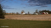
In a large open grazing ground for cows there is a large round barrow. This barrow is easily visible in the flat grassy landscape. It is around 30 metres in diameter and around 3 metres in height. It has probably been higher, but a large crater on top has probably destroyed much of the original shape. Today it appears a little flattened. It has large trees growing on it.
You may be viewing yesterday's version of this page. To see the most up to date information please register for a free account.
")
")
")
Do not use the above information on other web sites or publications without permission of the contributor.
Nearby Images from Flickr


The above images may not be of the site on this page, but were taken nearby. They are loaded from Flickr so please click on them for image credits.
Click here to see more info for this site
Nearby sites
Click here to view sites on an interactive map of the areaKey: Red: member's photo, Blue: 3rd party photo, Yellow: other image, Green: no photo - please go there and take one, Grey: site destroyed
Download sites to:
KML (Google Earth)
GPX (GPS waypoints)
CSV (Garmin/Navman)
CSV (Excel)
To unlock full downloads you need to sign up as a Contributory Member. Otherwise downloads are limited to 50 sites.
Turn off the page maps and other distractions
Nearby sites listing. In the following links * = Image available
462m NNW 330° Motlandshaugen* Round Barrow(s)
943m W 273° Hanabergshagen* Ancient Village or Settlement
1.1km WNW 288° Klauhauane av Auna-Motland* Ancient Village or Settlement
1.2km W 267° Hanabergsrudlå* Cairn
2.3km NNW 333° Nesheimhaugen* Round Barrow(s)
3.0km WSW 255° Reime* Round Barrow(s)
3.1km NW 309° Øvre Vodl* Round Barrow(s)
3.3km NE 42° Malhaugane* Round Barrow(s)
4.1km WSW 257° Obrestad* Barrow Cemetery
4.7km SSW 195° Varhaug Barrows* Round Barrow(s)
4.9km SSW 202° Kålhaug-Varhaug* Barrow Cemetery
5.0km S 188° Nyvlestadhaugo* Round Barrow(s)
5.6km WNW 285° Hå barrow cemetery* Barrow Cemetery
6.1km S 182° Haugelandshauen* Round Barrow(s)
6.1km S 187° Kolhauen* Round Barrow(s)
6.3km S 184° Bleigjehauen* Round Barrow(s)
6.4km S 188° Finnshaug* Barrow Cemetery
6.6km S 187° Sør-Husvegg* Barrow Cemetery
8.0km ENE 63° Riggjerdet* Ancient Village or Settlement
8.0km N 351° Ramshaug* Round Barrow(s)
8.1km N 355° Trollhaugen* Round Barrow(s)
8.6km S 178° Stavnheim* Barrow Cemetery
9.4km NNW 330° Træet* Barrow Cemetery
9.5km N 2° Varden* Round Barrow(s)
9.5km NNW 328° Erga-Brautvegen* Round Barrow(s)
View more nearby sites and additional images


 We would like to know more about this location. Please feel free to add a brief description and any relevant information in your own language.
 Wir möchten mehr über diese Stätte erfahren. Bitte zögern Sie nicht, eine kurze Beschreibung und relevante Informationen in Deutsch hinzuzufügen.
 Nous aimerions en savoir encore un peu sur les lieux. S'il vous plaît n'hesitez pas à ajouter une courte description et tous les renseignements pertinents dans votre propre langue.
 Quisieramos informarnos un poco más de las lugares. No dude en añadir una breve descripción y otros datos relevantes en su propio idioma.