<< Our Photo Pages >> Pierre du Carrefour des Sorcières - Natural Stone / Erratic / Other Natural Feature in Belgium in Luxembourg
Submitted by Alta-Falisa on Monday, 28 September 2015 Page Views: 1356
Natural PlacesSite Name: Pierre du Carrefour des SorcièresCountry: Belgium Province: Luxembourg Type: Natural Stone / Erratic / Other Natural Feature
Nearest Town: Marche-en-Famenne Nearest Village: Wéris
Latitude: 50.326570N Longitude: 5.531770E
Condition:
| 5 | Perfect |
| 4 | Almost Perfect |
| 3 | Reasonable but with some damage |
| 2 | Ruined but still recognisable as an ancient site |
| 1 | Pretty much destroyed, possibly visible as crop marks |
| 0 | No data. |
| -1 | Completely destroyed |
| 5 | Superb |
| 4 | Good |
| 3 | Ordinary |
| 2 | Not Good |
| 1 | Awful |
| 0 | No data. |
| 5 | Can be driven to, probably with disabled access |
| 4 | Short walk on a footpath |
| 3 | Requiring a bit more of a walk |
| 2 | A long walk |
| 1 | In the middle of nowhere, a nightmare to find |
| 0 | No data. |
| 5 | co-ordinates taken by GPS or official recorded co-ordinates |
| 4 | co-ordinates scaled from a detailed map |
| 3 | co-ordinates scaled from a bad map |
| 2 | co-ordinates of the nearest village |
| 1 | co-ordinates of the nearest town |
| 0 | no data |
Internal Links:
External Links:
I have visited· I would like to visit
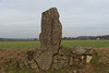
CharcoalBurner89 visited on 6th Nov 2023 - their rating: Cond: 3 Amb: 4 Access: 5 Presumed megalith. The origin of the stone (whether it really is a menhir or not) is not clear. But it looks nice in front of the museum.
")
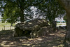
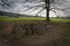
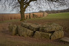
During earthmoving works along the Rue des Menhirs, near the Carrefour des Sorcières in Wéris, a block of pudding-stone has been discovered in the summer of 2012.
The lack of evidence of any human activities around the stone has lead to the provisional (or final) conclusion that the stone is simply a random pudding-stone.
There being no reason to keep it in place, it has been re-erected on the lawn of the Maison des Mégalithes (see separate entry : Cercle historique).
Bibliography :
Monolithe mystérieux
Pierre_poudingue
You may be viewing yesterday's version of this page. To see the most up to date information please register for a free account.
")
")
")
Do not use the above information on other web sites or publications without permission of the contributor.
Nearby Images from Flickr

The above images may not be of the site on this page, but were taken nearby. They are loaded from Flickr so please click on them for image credits.
Click here to see more info for this site
Nearby sites
Click here to view sites on an interactive map of the areaKey: Red: member's photo, Blue: 3rd party photo, Yellow: other image, Green: no photo - please go there and take one, Grey: site destroyed
Download sites to:
KML (Google Earth)
GPX (GPS waypoints)
CSV (Garmin/Navman)
CSV (Excel)
To unlock full downloads you need to sign up as a Contributory Member. Otherwise downloads are limited to 50 sites.
Turn off the page maps and other distractions
Nearby sites listing. In the following links * = Image available
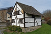
25m ESE 108° Cercle Historique* Museum
993m NW 318° Menhirs du Champ de la Longue Pierre* Standing Stone (Menhir)
997m NW 320° Wéris Dolmen* Burial Chamber or Dolmen
1.1km W 266° Alignement de Danthine* Stone Row / Alignment
1.1km NE 48° Pierre Haina* Rock Outcrop
1.2km W 259° Menhir Danthine* Standing Stone (Menhir)
1.2km SSW 207° Pas-Bayard* Rock Outcrop
1.2km NE 41° Lit du Diable* Rock Outcrop
1.3km NW 309° Bois du Vesin Menhir* Standing Stones
1.4km WSW 247° Oppagne Menhirs* Standing Stones
1.4km N 349° Menhir de Morville* Standing Stone (Menhir)
1.4km WSW 248° Oppagne Dolmen* Burial Chamber or Dolmen
1.9km WSW 238° Menhirs d'Oppagne* Standing Stones
4.2km NNE 15° Menhir de Heyd* Standing Stone (Menhir)
6.4km NNE 22° Ozo Menhir* Standing Stone (Menhir)
10.5km E 85° Chêne-al-Pierre Rock Outcrop
12.9km S 185° Source Miraculeuse de Saint Thibaut Holy Well or Sacred Spring
16.8km NNW 335° Grosse Pierre d'Ellemelle* Standing Stone (Menhir)
18.0km SW 231° Pierre de Pîrîre* Modern Stone Circle etc
18.4km SW 229° Pierre Saint-Hubert* Marker Stone
19.0km NNW 339° Borne seigneurale de Houchenée* Marker Stone
21.5km SW 227° Bois des Lus* Modern Stone Circle etc
21.8km WNW 303° Othée Tumulus* Barrow Cemetery
22.7km SSE 150° Monument Europalia Portugal* Modern Stone Circle etc
23.1km N 359° Fine Pierre de Plainevaux* Rock Outcrop
View more nearby sites and additional images


 We would like to know more about this location. Please feel free to add a brief description and any relevant information in your own language.
 Wir möchten mehr über diese Stätte erfahren. Bitte zögern Sie nicht, eine kurze Beschreibung und relevante Informationen in Deutsch hinzuzufügen.
 Nous aimerions en savoir encore un peu sur les lieux. S'il vous plaît n'hesitez pas à ajouter une courte description et tous les renseignements pertinents dans votre propre langue.
 Quisieramos informarnos un poco más de las lugares. No dude en añadir una breve descripción y otros datos relevantes en su propio idioma.