<< Other Photo Pages >> Andesina - Ancient Temple in France in Alsace-Lorraine:Vosges (88)
Submitted by KaiHofmann on Tuesday, 28 April 2015 Page Views: 2206
Multi-periodSite Name: Andesina Alternative Name: GrandesinaCountry: France
NOTE: This site is 2.06 km away from the location you searched for.
Département: Alsace-Lorraine:Vosges (88) Type: Ancient Temple
Nearest Town: Neufchâteau Nearest Village: Grand
Latitude: 48.385571N Longitude: 5.490760E
Condition:
| 5 | Perfect |
| 4 | Almost Perfect |
| 3 | Reasonable but with some damage |
| 2 | Ruined but still recognisable as an ancient site |
| 1 | Pretty much destroyed, possibly visible as crop marks |
| 0 | No data. |
| -1 | Completely destroyed |
| 5 | Superb |
| 4 | Good |
| 3 | Ordinary |
| 2 | Not Good |
| 1 | Awful |
| 0 | No data. |
| 5 | Can be driven to, probably with disabled access |
| 4 | Short walk on a footpath |
| 3 | Requiring a bit more of a walk |
| 2 | A long walk |
| 1 | In the middle of nowhere, a nightmare to find |
| 0 | No data. |
| 5 | co-ordinates taken by GPS or official recorded co-ordinates |
| 4 | co-ordinates scaled from a detailed map |
| 3 | co-ordinates scaled from a bad map |
| 2 | co-ordinates of the nearest village |
| 1 | co-ordinates of the nearest town |
| 0 | no data |
Internal Links:
External Links:
")
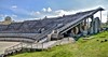
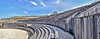
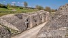
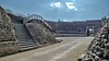
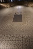
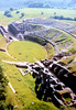
The village of Grand was 2000 years ago a Celtic holy well sanctuary. The Celtic tribes worshipped their god Grannus at this holy well. Today the well pond lies beneath the local church. Later it was a Gallo-Roman Appolo-Grannus sanctuary of nationwide importance. Today some ruins a large mosaic and a large Roman amphitheatre can also be visited.
You may be viewing yesterday's version of this page. To see the most up to date information please register for a free account.
")
Do not use the above information on other web sites or publications without permission of the contributor.
Nearby Images from Flickr
The above images may not be of the site on this page, but were taken nearby. They are loaded from Flickr so please click on them for image credits.
Click here to see more info for this site
Nearby sites
Click here to view sites on an interactive map of the areaKey: Red: member's photo, Blue: 3rd party photo, Yellow: other image, Green: no photo - please go there and take one, Grey: site destroyed
Download sites to:
KML (Google Earth)
GPX (GPS waypoints)
CSV (Garmin/Navman)
CSV (Excel)
To unlock full downloads you need to sign up as a Contributory Member. Otherwise downloads are limited to 50 sites.
Turn off the page maps and other distractions
Nearby sites listing. In the following links * = Image available
11.1km ENE 65° Dolmen du Bois du Comtot Burial Chamber or Dolmen
17.9km ESE 112° Grotte de L´Enfer et de Jeannuë Cave or Rock Shelter
19.4km ESE 115° Vielles-Roches Barrow Cemetery
24.0km SW 227° Dolmen dit la Pierre qui Tourne Burial Chamber or Dolmen
24.0km SW 227° Coffres de Fort Bévaux (Septfontaines) Barrow Cemetery
24.3km SE 127° Beaufremont-St-Charles necropolis Barrow Cemetery
24.6km SE 131° Coffre du Bois-Saint-Charles Burial Chamber or Dolmen
27.2km SW 228° Dolmen du Bois de la Grande-Bay Burial Chamber or Dolmen
27.5km SSW 199° Menhir dit la Pierre Bernard Standing Stone (Menhir)
28.9km NNW 348° Oppidum des Leuci* Ancient Village or Settlement
33.2km WNW 304° La Haute Borne de Fontaines-sur-Marne* Standing Stone (Menhir)
39.2km NNW 327° Menhir de Champ l'Ecuyer Standing Stone (Menhir)
39.7km NNW 329° Menhir de la Chèvre Standing Stone (Menhir)
40.4km NW 325° Allée Couverte du Ruissard Passage Grave
41.5km NW 324° Menhir le Corrois Standing Stone (Menhir)
42.2km SSW 199° La Pierre Tournante Dolmen Burial Chamber or Dolmen
43.0km NNW 328° Champ l'Alouette Menhir Standing Stone (Menhir)
44.0km NE 49° Grottes dites Trou de Sainte-Reine Cave or Rock Shelter
44.4km NE 50° Grotte le Trou-des-Celtes Cave or Rock Shelter
44.6km SSW 196° Menhir du Bois de Lardigny* Standing Stone (Menhir)
44.9km SSW 195° Allée Couverte de Mauvaignant Passage Grave
45.0km SSW 195° Dolmen de la Pierre-Alot* Burial Chamber or Dolmen
46.0km SE 135° Dolmen de Pissotte Burial Chamber or Dolmen
46.8km N 4° Le Menhir des 3 évêchés* Standing Stone (Menhir)
47.1km NE 54° Bois de l'Evêque Dolmen Burial Chamber or Dolmen
View more nearby sites and additional images


 We would like to know more about this location. Please feel free to add a brief description and any relevant information in your own language.
 Wir möchten mehr über diese Stätte erfahren. Bitte zögern Sie nicht, eine kurze Beschreibung und relevante Informationen in Deutsch hinzuzufügen.
 Nous aimerions en savoir encore un peu sur les lieux. S'il vous plaît n'hesitez pas à ajouter une courte description et tous les renseignements pertinents dans votre propre langue.
 Quisieramos informarnos un poco más de las lugares. No dude en añadir una breve descripción y otros datos relevantes en su propio idioma.