
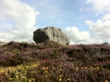

<< Our Photo Pages >> Les Pierres Martines - Standing Stone (Menhir) in France in Nord:Nord (59)
Submitted by Alta-Falisa on Tuesday, 17 May 2005 Page Views: 3748
Neolithic and Bronze AgeSite Name: Les Pierres MartinesCountry: France Département: Nord:Nord (59) Type: Standing Stone (Menhir)
Nearest Town: Maubeuge Nearest Village: Solre-le-Château
Latitude: 50.164505N Longitude: 4.084113E
Condition:
| 5 | Perfect |
| 4 | Almost Perfect |
| 3 | Reasonable but with some damage |
| 2 | Ruined but still recognisable as an ancient site |
| 1 | Pretty much destroyed, possibly visible as crop marks |
| 0 | No data. |
| -1 | Completely destroyed |
| 5 | Superb |
| 4 | Good |
| 3 | Ordinary |
| 2 | Not Good |
| 1 | Awful |
| 0 | No data. |
| 5 | Can be driven to, probably with disabled access |
| 4 | Short walk on a footpath |
| 3 | Requiring a bit more of a walk |
| 2 | A long walk |
| 1 | In the middle of nowhere, a nightmare to find |
| 0 | No data. |
| 5 | co-ordinates taken by GPS or official recorded co-ordinates |
| 4 | co-ordinates scaled from a detailed map |
| 3 | co-ordinates scaled from a bad map |
| 2 | co-ordinates of the nearest village |
| 1 | co-ordinates of the nearest town |
| 0 | no data |
Internal Links:
External Links:
")
The oldest written mention of this site goes back to 1819 and is due to the mayor of the village. He only mentioned one stone, then locally called Pierre de Saint Martin. But as of 1826, two stones are consistently mentioned, a large one (about 3 m high) and a small one (about 1 m high). It is even possible to recognize both of them on a painting from the early 17th century.
In 1862, when the French government issued a list of megalithic monuments, 2 menhirs were entered in Solre-le-Château.
In 1874, the smallest had already been destroyed, most probably converted into building material to pave the roads. The destruction was duly reported to the Administration. Nevertheless, when officially classified in January 1889, the site was still described as Two Menhirs called les pierres Martines (in French, of course !).
In 1913, 40 years after the destruction of the smallest stone, both were still recorded in the inventory finalized 31 December 1913 as Two Menhirs called "les Pierres-Martines".
In 1924, the site was fully described (see bibliography) for the first time : there was only one large stone supported by two small ones, which are not the debris of the one destroyed in 1874.
Today, the site comprises exactly the same stones as documented in 1924, and probably still stands as it was in 1874.
Photo taken April 2014.
Bibliography : M.Desailly : Le Menhir de Solre-le-Château, in Bulletin de la Société préhistorique de France, 1924, vol.21, n°5,139-46. http://www.persee.fr/web/revues/home/prescript/article/bspf_0249-7638_1924_num_21_5_7300
You may be viewing yesterday's version of this page. To see the most up to date information please register for a free account.
")
")
")
")
Do not use the above information on other web sites or publications without permission of the contributor.
Nearby Images from Flickr
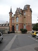
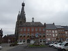
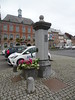
The above images may not be of the site on this page, but were taken nearby. They are loaded from Flickr so please click on them for image credits.
Click here to see more info for this site
Nearby sites
Click here to view sites on an interactive map of the areaKey: Red: member's photo, Blue: 3rd party photo, Yellow: other image, Green: no photo - please go there and take one, Grey: site destroyed
Download sites to:
KML (Google Earth)
GPX (GPS waypoints)
CSV (Garmin/Navman)
CSV (Excel)
To unlock full downloads you need to sign up as a Contributory Member. Otherwise downloads are limited to 50 sites.
Turn off the page maps and other distractions
Nearby sites listing. In the following links * = Image available
4.0km W 281° La Pierre de Dessus-Bise* Standing Stone (Menhir)
4.0km WNW 282° Sars-Poteries* Standing Stones
9.5km E 98° La Pierre Qui Tourne de Sautin* Polissoir
10.0km WSW 241° Avesnes-Sur-Helpe Oppidum Hillfort
13.4km E 100° Rouge de Rance* Modern Stone Circle etc
19.6km ENE 57° Dolmen du Mont de Viscourt* Burial Chamber or Dolmen
24.4km N 360° Pierre qui Pousse (Haulchin)* Standing Stone (Menhir)
25.6km NW 306° Bavay Musée Archéologique* Museum
25.9km NE 54° Menhir de Cour-sur-Heure* Standing Stone (Menhir)
26.2km NE 46° Zeupire Standing Stone* Standing Stone (Menhir)
26.9km ESE 121° Pierre qui Tourne (Baileux)* Standing Stone (Menhir)
28.0km N 3° Menhir d'Estinnes* Standing Stone (Menhir)
28.8km NW 309° Menhir dit la Pierre Croûte* Standing Stone (Menhir)
29.0km N 3° La Pierre de Bray* Standing Stone (Menhir)
29.3km NNW 346° Silex's* Museum
30.9km N 350° Polissoir de Saint-Symphorien* Polissoir
34.2km W 263° Le-Polissoir-d'Ors* Standing Stone (Menhir)
35.4km SW 219° Menhir de Chigny Standing Stone (Menhir)
35.5km ESE 108° Roche Trouée* Cave or Rock Shelter
35.6km NNE 17° Musée Royal de Mariemont* Museum
35.6km SSW 195° Menhir dit la Haute Borne (La Bouteille)* Standing Stone (Menhir)
42.6km WNW 286° Menhir dit le Gros Caillou* Standing Stone (Menhir)
43.3km E 101° Malgré Tout* Museum
46.8km NW 318° Bernissart, Jardin Géologique* Museum
49.8km W 259° Menhir de Clary* Standing Stone (Menhir)
View more nearby sites and additional images


 We would like to know more about this location. Please feel free to add a brief description and any relevant information in your own language.
 Wir möchten mehr über diese Stätte erfahren. Bitte zögern Sie nicht, eine kurze Beschreibung und relevante Informationen in Deutsch hinzuzufügen.
 Nous aimerions en savoir encore un peu sur les lieux. S'il vous plaît n'hesitez pas à ajouter une courte description et tous les renseignements pertinents dans votre propre langue.
 Quisieramos informarnos un poco más de las lugares. No dude en añadir una breve descripción y otros datos relevantes en su propio idioma.