<< Other Photo Pages >> Kurul Fortress - Hillfort in Turkey
Submitted by davidmorgan on Wednesday, 15 March 2017 Page Views: 5079
Site WatchSite Name: Kurul Fortress Alternative Name: Kurul KalesiCountry: Turkey
NOTE: This site is 58.945 km away from the location you searched for.
Type: Hillfort
Nearest Town: Ordu Nearest Village: Bayadı
Latitude: 40.902200N Longitude: 37.915600E
Condition:
| 5 | Perfect |
| 4 | Almost Perfect |
| 3 | Reasonable but with some damage |
| 2 | Ruined but still recognisable as an ancient site |
| 1 | Pretty much destroyed, possibly visible as crop marks |
| 0 | No data. |
| -1 | Completely destroyed |
| 5 | Superb |
| 4 | Good |
| 3 | Ordinary |
| 2 | Not Good |
| 1 | Awful |
| 0 | No data. |
| 5 | Can be driven to, probably with disabled access |
| 4 | Short walk on a footpath |
| 3 | Requiring a bit more of a walk |
| 2 | A long walk |
| 1 | In the middle of nowhere, a nightmare to find |
| 0 | No data. |
| 5 | co-ordinates taken by GPS or official recorded co-ordinates |
| 4 | co-ordinates scaled from a detailed map |
| 3 | co-ordinates scaled from a bad map |
| 2 | co-ordinates of the nearest village |
| 1 | co-ordinates of the nearest town |
| 0 | no data |
Internal Links:
External Links:
")
But although archaeological works continue to be conducted on the castle, dynamite is detonated every day on the slope of the Kurul Rocks overlooking the Melet River, creating grave danger for the castle. See the comment below for more details.
Note: Goddess statue and 2100-year-old castle threatened by dynamite in the north of Turkey
You may be viewing yesterday's version of this page. To see the most up to date information please register for a free account.
")
")
Do not use the above information on other web sites or publications without permission of the contributor.
Nearby Images from Flickr

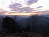
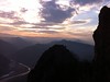


The above images may not be of the site on this page, but were taken nearby. They are loaded from Flickr so please click on them for image credits.
Click here to see more info for this site
Nearby sites
Click here to view sites on an interactive map of the areaKey: Red: member's photo, Blue: 3rd party photo, Yellow: other image, Green: no photo - please go there and take one, Grey: site destroyed
Download sites to:
KML (Google Earth)
GPX (GPS waypoints)
CSV (Garmin/Navman)
CSV (Excel)
To unlock full downloads you need to sign up as a Contributory Member. Otherwise downloads are limited to 50 sites.
Turn off the page maps and other distractions
Nearby sites listing. In the following links * = Image available
115.0km WSW 257° Horoztepe Ancient Village or Settlement
126.5km WNW 286° Tekkekoy Caves Cave or Rock Shelter
150.1km SW 233° Bolus Ancient Village or Settlement
152.2km E 85° St Anna, Trabzon* Ancient Cross
178.3km W 262° Amasya Museum* Museum
184.9km SW 220° Kayalipinar Ancient Village or Settlement
188.4km WNW 296° Ikiztepe Ancient Village or Settlement
196.8km W 259° Oluz Mound* Ancient Village or Settlement
196.8km SSW 206° Sarissa Ancient Village or Settlement
198.8km SE 132° Altintepe Ancient Village or Settlement
200.0km SE 131° Kildirik Ancient Village or Settlement
200.4km WSW 246° Masat Hoyuk Ancient Village or Settlement
201.6km SE 130° Asagi Agindir Dam Ancient Mine, Quarry or other Industry
201.7km SE 130° Yukari Agindir Dam Ancient Mine, Quarry or other Industry
211.2km W 280° Oymaagac Mound Artificial Mound
237.5km WSW 253° Shapinuwa Ancient Village or Settlement
245.8km SSW 205° Karakuyu Hittite Dam* Ancient Mine, Quarry or other Industry
248.8km WSW 242° Karakiz* Carving
253.0km W 262° Çorum Archaeological Museum Museum
258.3km WSW 257° Pazarli Ancient Village or Settlement
266.4km SW 235° Sarikaya Roman Bath* Ancient Village or Settlement
267.4km WSW 238° Alisar Hoyuk* Ancient Village or Settlement
268.9km SSE 155° Harput Relief* Sculptured Stone
269.6km WSW 252° Örükaya Roman Dam Ancient Mine, Quarry or other Industry
270.7km SSE 156° Elazig Museum Museum
View more nearby sites and additional images
Rare 1,400-year-old bronze Byzantine-era coins found near Jerusalem highway >>


 We would like to know more about this location. Please feel free to add a brief description and any relevant information in your own language.
 Wir möchten mehr über diese Stätte erfahren. Bitte zögern Sie nicht, eine kurze Beschreibung und relevante Informationen in Deutsch hinzuzufügen.
 Nous aimerions en savoir encore un peu sur les lieux. S'il vous plaît n'hesitez pas à ajouter une courte description et tous les renseignements pertinents dans votre propre langue.
 Quisieramos informarnos un poco más de las lugares. No dude en añadir una breve descripción y otros datos relevantes en su propio idioma.