<< Our Photo Pages >> Jerash - Ancient Village or Settlement in Jordan
Submitted by h_fenton on Saturday, 15 December 2007 Page Views: 6051
Multi-periodSite Name: Jerash Alternative Name: GerasaCountry: Jordan
NOTE: This site is 13.235 km away from the location you searched for.
Type: Ancient Village or Settlement
Nearest Town: Jerash
Latitude: 32.279285N Longitude: 35.891808E
Condition:
| 5 | Perfect |
| 4 | Almost Perfect |
| 3 | Reasonable but with some damage |
| 2 | Ruined but still recognisable as an ancient site |
| 1 | Pretty much destroyed, possibly visible as crop marks |
| 0 | No data. |
| -1 | Completely destroyed |
| 5 | Superb |
| 4 | Good |
| 3 | Ordinary |
| 2 | Not Good |
| 1 | Awful |
| 0 | No data. |
| 5 | Can be driven to, probably with disabled access |
| 4 | Short walk on a footpath |
| 3 | Requiring a bit more of a walk |
| 2 | A long walk |
| 1 | In the middle of nowhere, a nightmare to find |
| 0 | No data. |
| 5 | co-ordinates taken by GPS or official recorded co-ordinates |
| 4 | co-ordinates scaled from a detailed map |
| 3 | co-ordinates scaled from a bad map |
| 2 | co-ordinates of the nearest village |
| 1 | co-ordinates of the nearest town |
| 0 | no data |
Internal Links:
External Links:
I have visited· I would like to visit
Kuba visited on 31st Mar 2022 - their rating: Cond: 4 Amb: 4 Access: 5
XIII visited on 1st Mar 2014 - their rating: Cond: 3 Amb: 4 Access: 5
h_fenton MegalithJunkie mrcrow have visited here
Average ratings for this site from all visit loggers: Condition: 3.5 Ambience: 4 Access: 5

Jerash (Roman Gerasa)
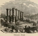
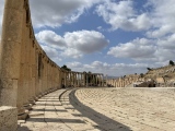
The earliest finds from this site date to the Neolithic. No one is certain when the settlement her began to develop but the city started to prosper after the time of Alexander the Great (4th century BCE). Jerash was conquered by the Romans in 64 BCE, and for the next 150 years the city grew much richer through trade with the neighbouring Nabatean Kingdom. Jerash benefited from being surrounded by rich farmlands and also had iron ore mines nearby at Ajloun. The city centre was remodelled in the 1st century CE with a colonnaded main street which was intersected by two main side streets.
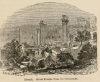
In the early 2nd century CE Emperor Trajan annexed the neighbouring Nabatean Kingdom which had been very wealthy and did a lot of trade with Jerash. The Romans then made improvements to the road network in the region which included the creation of new major roads which further increased trade through Jerash. This increase in trade bought so much wealth for the city that some old temples and other buildings in the city were rebuilt in the latest architectural styles. In 129 CE Emperor Trajan paid a visit to the city and a triumphal arch at the southern end of the city was erected in his honour. The city had reached its climax by the early years of the 3rd century CE and by the end of the century the city was in decline, regional disturbances had upset the overland trade routes and trade though the region had become far less important.
The Persians invaded in 614 CE, followed by the Muslims in 636AD and then there was a major earthquake in 747 CE all of these events pushed Jerash into ever further decline. By the time of the Crusades in the 12th century Jerash had been completely abandoned. In the early 19th century the city was rediscovered, in the intervening years it had become deeply buried in sand, excavations did not start until 1925.
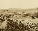
What remains to be seen today is the Administrative, civic and commercial centre, much of the rest of the city remains unexcavated, further remains lie buried under the modern town immediately to the east of the site.
Sources:
Greenway, P. & Simonis, D. (2000) Jordan (4th Edition)
VICTORIA (AUSTRALIA): Lonely Planet
http://www.kinghussein.gov.jo/tourism3.html
Accessed: 15/12/2007
---
Google Maps (satellite view of Jerash)
You may be viewing yesterday's version of this page. To see the most up to date information please register for a free account.


Do not use the above information on other web sites or publications without permission of the contributor.
Click here to see more info for this site
Nearby sites
Click here to view sites on an interactive map of the areaKey: Red: member's photo, Blue: 3rd party photo, Yellow: other image, Green: no photo - please go there and take one, Grey: site destroyed
Download sites to:
KML (Google Earth)
GPX (GPS waypoints)
CSV (Garmin/Navman)
CSV (Excel)
To unlock full downloads you need to sign up as a Contributory Member. Otherwise downloads are limited to 50 sites.
Turn off the page maps and other distractions
Nearby sites listing. In the following links * = Image available
23.8km N 357° Jdeta* Burial Chamber or Dolmen
31.5km N 352° Irbid* Ancient Village or Settlement
32.3km NW 306° Pella (Jordan) Ancient Village or Settlement
32.9km NNW 345° Rasun (Jordan)* Burial Chamber or Dolmen
33.4km SSE 166° Ain Ghazal* Ancient Village or Settlement
34.2km NW 308° Wadi Hammeh 27 Ancient Village or Settlement
35.3km WNW 294° Tel Tsaf* Ancient Village or Settlement
36.3km S 174° Amman Citadel* Ancient Village or Settlement
36.4km S 174° Jordan Archaeological Museum* Museum
36.7km S 176° Amman.* NOT SET
36.9km WSW 237° Damiyah dolmen field* Burial Chamber or Dolmen
38.0km WSW 250° Argaman-Gilgal sanctuary Ancient Temple
43.4km NNE 28° Tal al-Ashari Barrow Cemetery
44.2km NW 305° Tel Beth Shean* Ancient Village or Settlement
45.2km E 83° Umm el-Jimal* Ancient Village or Settlement
45.6km S 180° Tall al-Umayri* Ancient Village or Settlement
46.0km ESE 117° Qasr al-Hallabat* Stone Fort or Dun
47.5km WNW 285° Gadara* Ancient Village or Settlement
51.1km WNW 302° Beit Alpha Ancient Synagogue Mosaic Floor* Ancient Temple
52.0km S 190° Hesbon* Burial Chamber or Dolmen
52.5km NNW 329° Sha'ar HaGolan* Ancient Village or Settlement
53.7km SSW 201° Rawdah* Burial Chamber or Dolmen
56.5km NNW 328° Tel Bet Yerah Artificial Mound
57.1km NNW 329° Sea of Galilee Cairn* Cairn
57.1km NNW 328° Ohalo II* Ancient Village or Settlement
View more nearby sites and additional images


 We would like to know more about this location. Please feel free to add a brief description and any relevant information in your own language.
 Wir möchten mehr über diese Stätte erfahren. Bitte zögern Sie nicht, eine kurze Beschreibung und relevante Informationen in Deutsch hinzuzufügen.
 Nous aimerions en savoir encore un peu sur les lieux. S'il vous plaît n'hesitez pas à ajouter une courte description et tous les renseignements pertinents dans votre propre langue.
 Quisieramos informarnos un poco más de las lugares. No dude en añadir una breve descripción y otros datos relevantes en su propio idioma.