

<< Our Photo Pages >> Crescent-shaped monument near Shefer - Artificial Mound in Israel
Submitted by motist on Friday, 03 October 2014 Page Views: 2547
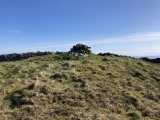
Multi-periodSite Name: Crescent-shaped monument near SheferCountry: Israel
NOTE: This site is 2.7 km away from the location you searched for.
Type: Artificial Mound
Nearest Town: Zefat Nearest Village: 'Ain Al Asad
Latitude: 32.939314N Longitude: 35.426735E
Condition:
| 5 | Perfect |
| 4 | Almost Perfect |
| 3 | Reasonable but with some damage |
| 2 | Ruined but still recognisable as an ancient site |
| 1 | Pretty much destroyed, possibly visible as crop marks |
| 0 | No data. |
| -1 | Completely destroyed |
| 5 | Superb |
| 4 | Good |
| 3 | Ordinary |
| 2 | Not Good |
| 1 | Awful |
| 0 | No data. |
| 5 | Can be driven to, probably with disabled access |
| 4 | Short walk on a footpath |
| 3 | Requiring a bit more of a walk |
| 2 | A long walk |
| 1 | In the middle of nowhere, a nightmare to find |
| 0 | No data. |
| 5 | co-ordinates taken by GPS or official recorded co-ordinates |
| 4 | co-ordinates scaled from a detailed map |
| 3 | co-ordinates scaled from a bad map |
| 2 | co-ordinates of the nearest village |
| 1 | co-ordinates of the nearest town |
| 0 | no data |
Internal Links:
External Links:
")
Pottery excavated at the structure indicates the monument dates to between 3050 B.C. and 2650 B.C., so probably older than the pyramids of Egypt.
Archaeologists previously thought the structure was part of a city wall, but recent work carried out by Ido Wachtel, a doctoral student at the Hebrew University of Jerusalem, indicates there is no city beside it and that the structure is a standing monument.
The structure's crescent shape stood out in the landscape, Wachtel told Live Science He has suggested the shape may have had symbolic importance, as the lunar crescent is a symbol of Sin, the ancient Mesopotamian moon god.
More at Live Science.
Moti writes: All the lunar crescents I know are pointing upwards, this one points downwards
You may be viewing yesterday's version of this page. To see the most up to date information please register for a free account.
")
Do not use the above information on other web sites or publications without permission of the contributor.
Nearby Images from Flickr


The above images may not be of the site on this page, but were taken nearby. They are loaded from Flickr so please click on them for image credits.
Click here to see more info for this site
Nearby sites
Click here to view sites on an interactive map of the areaKey: Red: member's photo, Blue: 3rd party photo, Yellow: other image, Green: no photo - please go there and take one, Grey: site destroyed
Download sites to:
KML (Google Earth)
GPX (GPS waypoints)
CSV (Garmin/Navman)
CSV (Excel)
To unlock full downloads you need to sign up as a Contributory Member. Otherwise downloads are limited to 50 sites.
Turn off the page maps and other distractions
Nearby sites listing. In the following links * = Image available
7.8km SE 140° Hukok* Ancient Temple
9.5km WNW 297° PEKI''IN old Synagogue * Ancient Temple
10.5km NE 47° Naburiya synagogue in Biriya Forest* Ancient Temple
11.7km N 354° Baram Synagogue* Ancient Temple
13.5km SE 145° Dalmanutha* Ancient Village or Settlement
14.7km W 275° Khirbet Mehoz* Ancient Village or Settlement
15.2km WSW 253° Hilazon Tachtit* Cave or Rock Shelter
15.8km ENE 57° Tel Hatzor* Artificial Mound
18.3km SW 229° Tel Yodfat * Hillfort
19.3km E 100° Bethsaida* Ancient Village or Settlement
19.6km W 264° HaYonim cave* Cave or Rock Shelter
21.6km NNE 26° Tel Kadesh Naftali* Ancient Village or Settlement
22.5km SSE 149° Hammat Tiberias* Ancient Village or Settlement
24.2km WNW 296° Manot cave* Cave or Rock Shelter
24.4km ESE 121° Kursi National Park* Ancient Village or Settlement
24.5km W 263° Ahihud Ancient Settlement* Ancient Village or Settlement
24.9km SSW 213° Tzippori* Ancient Village or Settlement
27.2km SSW 212° 'Ain zippori* Ancient Village or Settlement
28.0km SE 128° NEG II Prehistoric Village* Ancient Village or Settlement
28.0km SE 128° Wadi Ein Gev Ancient Village or Settlement
28.1km WNW 286° Tel Kabri* Ancient Palace
28.1km SE 129° Sussita* Ancient Village or Settlement
28.3km SSE 150° Sea of Galilee Cairn* Cairn
28.3km SSE 151° Ohalo II* Ancient Village or Settlement
28.9km SSE 151° Tel Bet Yerah Artificial Mound
View more nearby sites and additional images


 We would like to know more about this location. Please feel free to add a brief description and any relevant information in your own language.
 Wir möchten mehr über diese Stätte erfahren. Bitte zögern Sie nicht, eine kurze Beschreibung und relevante Informationen in Deutsch hinzuzufügen.
 Nous aimerions en savoir encore un peu sur les lieux. S'il vous plaît n'hesitez pas à ajouter une courte description et tous les renseignements pertinents dans votre propre langue.
 Quisieramos informarnos un poco más de las lugares. No dude en añadir una breve descripción y otros datos relevantes en su propio idioma.